• start here
  • about
  • group trips
  • brooke beyond

  • hiking guides
  • outdoor gear
    • hiking boots
    • hiking backpacks
    • cold-weather layers
    • backpacking tent
    • outdoor sleep system
    • backcountry food
    • day-hike packing list
    • hut-to-hut packing list
    • via ferrata packing list
    • backpacking packing list
    • mountaineering packing list

brooke beyond

Europe / France / Italy

Up in the clouds: Ogling Mont Blanc from Aiguille du Midi

13 July 2017

Last Updated on 9 February 2021

Aiguille du Midi is a large peak (3,842m) within the Mont Blanc massif that offers unparalleled views of the incredible Mont Blanc itself (4,810m)— I knew I had to see Mont Blanc up close, especially considering I’m expelling all this energy just to circumnavigate the mountain on the Tour du Mont Blanc. Aiguille du Midi is easily accessed by cable car from Chamonix, France, but it’s also possible to reach the peak from Courmayeur, Italy. And wow, what a view.

 -
Map from Chamonix.com

All the details: Aiguille du Midi

Cost: Return tickets on the cable cars to Punta Helbronner are 48€, but you’ll also need to buy Panoramic Mont Blanc tickets (29€) to take you the rest of the way to Aiguille to Midi on the French side. It’s easy to purchase both of these on arrival.

Getting there: Catch a bus from the Tourist Information office in the centre of Courmayeur to the Skyway Monte Bianco (about 20min).

Where to stay: The charming Albergo Le Marmotte is a little bit out of town, but it’s easily reached by an easy, quick bus and offers much more reasonably priced accomodation than other more centrally-located options (still 80€ per night, but at least brekky is included). And the VIEWS.

Top tips: Once you reach Aiguille du Midi, there are heaps of platforms and lookouts offering various views over the Mont Blanc massif, but if you are keen on taking “A Step into the Void” (walking across the special glass-bottom lookout), queue up early. The line can get quite long, so best to do this first and then spend a few hours exploring afterwards!


The alarm goes off at 7am and I roll over to continue sleeping in my comfy bed just a little longer. After my crazy long day combining two stages of the TMB yesterday, I am planning to have a relaxing morning and make a late start back on the trail. I’m hoping to combine stages 5, 6 & 7 over the next two days to arrive a day early in Champex, Switzerland, so I need all the rest I can get.

I’m staying in a cute little marmotte-decorated B&B with my friend Katy, and when we do get up, it’s to go down the hall to the breakfast that the Italian grandma running the hotel has prepared for us. After a delicious spread of breads and croissants and yogurts and juices, we set out for the main attraction― Aiguille du Midi.


Last night, we asked the (somewhat) English-speaking grandson of the hotel owner if we could reach the amazing Aiguille du Midi from Courmayeur, and he told us that not only is it reachable, it’s much newer and better than the access from the French side. Sensing some country rivalry here, we take a quick bus this morning from our hotel to the tourist information office in town, where we catch another bus about 20 minutes to the bottom of the Skyway Monte Bianco.

On the bus, we bump into Tulia and Samir, a couple we met together when Katy walked with me on the first day of the hike, and that I’ve run into every single day since. Of course they are off to Aiguille du Midi as well, having finished the section of the hike they came to do, so we all chat in line.


For 48€, we buy tickets that will take us from Courmayeur to the Pavillon du Mont Fréty and then to Punta Helbronner, all via cable car. From Helbronner, we will be able to buy Panoramic Mont Blanc tickets that will take us all the way to Aiguille to Midi on the French side for another 29€. All worth it, I am assured by everyone on the Internet.

The cable car ride to this first point only takes a few minutes, where we are packed like sardines into a glass car that slowly rotates so that everyone can marvel at the view, and even at Pavillon du Mont Fréty, which is a modest 2,173m, we are gaping at the incredible mountain-scapes.

After taking a few dozen photos, we get in line for the second cable car ascent up to Punta Halbronner, which sits much closer to Mont Blanc at 3,466m. This point is even more spectacular than the last, and we spend a bit longer here snapping photos of the imposing Monte Bianco, as the Italians call it.


Finally, we queue up to buy tickets to Aiguille du Midi, which turns out to be quite a lengthy experience. We wait nearly 45 minutes before we are ushered into a much smaller 4-person gondola and set off on the 20 minute journey across the most incredible mountain range I’ve ever seen.

I spend the entire ride sticking my camera (and my head) out the tiny window, practically crying over the views we are entirely surrounded by. We can also see tiny specks moving across the glaciers and snowfields below us, even a few larger specks that look a bit like tents. More shocking than the ice climbers, the gondola swings us right by rock climbers tackling a large rock peak. Give me another ten years to refine my climbing skills and, who knows, it could be me. 


Climbers at Aiguille du Midi


Once at the top, we are let out of the gondola into a rambling network of platforms that offer views of Mont Blanc from every possible angle. I’m like a child at Disneyland. We spend a good hour exploring all sides of the mountain, as well as the other spectacular peaks in the range, before we hop into a very lengthy line to take the lift up to the uppermost viewing point.

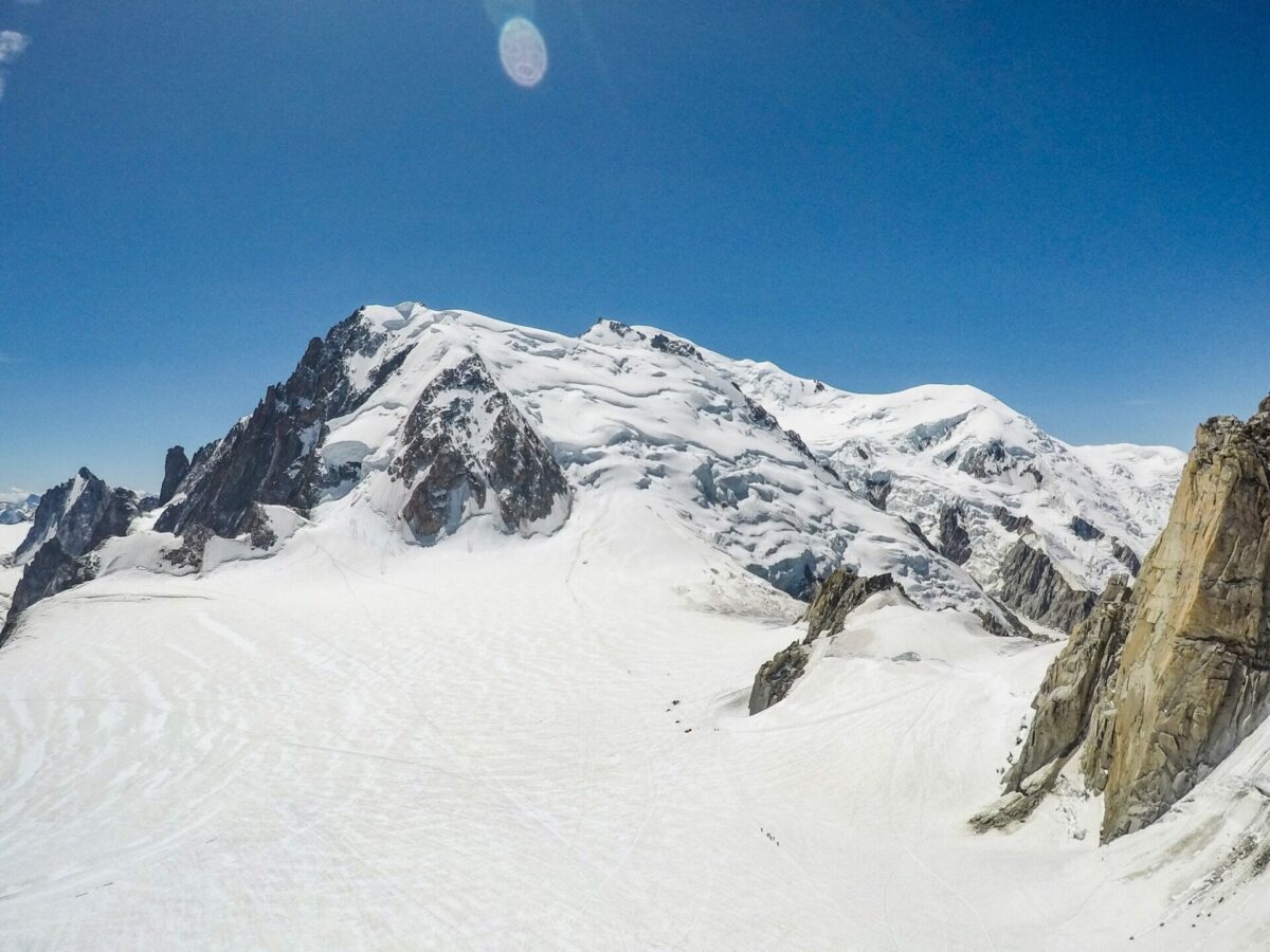
We are both a bit hangry at this point, but the 15 minute wait is well worth it when we reach the top and look nearly head-on at Mont Blanc. Katy reckons one of the smaller peaks is more spectacular, but I just can’t get enough of the main event.


We take even more photos and then descend to the lower platform to enjoy sandwiches and Orangina for lunch, all the while maintaining eye contact with the mountains. It’s about 3pm at this point, and it’s obvious I won’t be able to make it back on the trail today. I decide to stay another night in Courmayeur and head out early in the morning, hopefully making it to Refugio Elena tomorrow night, which is half-way through stage 6. The extra rest should certainly help me squish these 3 stages into 2 days, so I’m not horribly upset.

We meander back down through the various cable cars, not dawdling but also not stressing, and we don’t make it to the bottom until 430pm, where we have to wait until 5pm for a bus back into town. It’s clear that hiking today would have been impossible, as this whole experience has taken well over 6 hours. Worth it, though!


When we arrive back in Courmayeur, we bee-line for the gelato place we ate at last night and spend an hour enjoying our sweet treats while we wait for restaurants to open for dinner. Someone at the table next to us is waving, and it takes a second before I recognise him as one of the French men I walked with on day 2. Sure enough, I glance around the table and spot all the familiar faces of Philippe and Jean-Claude and Co., and we all have a quick catch-up about the hike so far. They are impressed to hear that I made it here last night, since they only just got in, and we wish each other luck on the rest of the hike and hope we may cross paths again! The rate at which I’ve been running into people makes it seem quite likely.

At 7pm, we head over to the restaurant Katy’s had her eye on and indulge in some delicious Italian cuisine, gnocchi for Katy and a gorgonzola pizza for me. Stuffed to the gills, we waddle back to the bus stop to buzz back home and get my things in order for an early departure tomorrow. I’m excited to get back on the trail, but my body does not share this feeling.

Read my TMB hiking journal

TOUR DU MONT BLANC DAY 1: LES HOUCHES – LES CONTAMINES

TOUR DU MONT BLANC DAY 2: LES CONTAMINES – COL DES FOURS – LES MOTTETS

TOUR DU MONT BLANC DAY 3: LES MOTTETS – RIFUGIO ELISABETTA – COURMAYEUR

TOUR DU MONT BLANC DAY 4:  COURMAYEUR – RIFUGIO BONATTI – LA PEULE

TOUR DU MONT BLANC DAY 5: LA PEULE – CHAMPEX

TOUR DU MONT BLANC DAY 6: CHAMPEX – FENÊTRE D’ARPETTE – LE PEUTY

TOUR DU MONT BLANC DAY 7: LE PEUTY – TRÉ-LE-CHAMP

TOUR DU MONT BLANC DAY 8: TRÉ-LE-CHAMP – LAC BLANC – LA FLEGERE – CHAMONIX

And plan your own amazing TMB hike!

THE ULTIMATE GUIDE TO SOLO HIKING & CAMPING THE TOUR DU MONT BLANC

HIGHLIGHTS FROM SOLO HIKING THE TOUR DU MONT BLANC

0 Comments
Share
brooke beyond

Hey, I'm Brooke and I'm obsessed with getting off the beaten path, exploring backcountry gems & travelling beyond the ordinary! I left Australia 5 years ago after finishing a PhD in Biomechanics & have been travelling the world full-time ever since (joined by my life/climbing partner, James). Whether it’s road-tripping through Mexico, climbing alpine peaks in the Andes, scuba diving in the Red Sea, or tackling epic via ferrata in the Dolomites, I hope this blog will inspire your future adventures & help you find wonder in every corner of the globe. xx bb

Leave a Comment Cancel Comment

You May Also Like

3 November 2016

Disneyland Paris: the happiest place in France

5 June 2023

Alta Via 4 (day 4): Rifugio Vandelli to Rifugio San Marco + Via Ferrata Giro di Sorapis

11 October 2022

Alta Via 2 (day 12): Rifugio Boz to Croce d’Aune

hi, I’m brooke!

I'm obsessed with getting off the beaten path, exploring backcountry gems & travelling beyond the ordinary! I left Australia 5 years ago after finishing a PhD in Biomechanics & have been travelling the world full-time ever since (now joined by my life/climbing partner, James). I hope this blog will inspire your future adventures & help you find wonder in every corner of the globe. xx bb

read my story
currently exploring

currently exploring

mexico

read our gear guides

🥾 hiking boots

🎒 hiking backpacks

🌨️ cold-weather layers

⛺️ backpacking & alpine tents

🛌 sleeping bag & pads

🍪 backcountry food

📸 travel camera gear

✈️ travel clothing

trail guides

summit guides

itineraries

outdoor gear

GPS maps

recent posts

  • Climbing Iztaccíhuatl volcano

    2-week Mexico volcanoes itinerary: climbing Pico de Orizaba, Izta, Malinche & Toluca

    3 June 2025
  • Mexico City: the perfect 5-day itinerary for CDMX

    31 May 2025
  • Climbing Iztaccíhuatl volcano

    Driving in Mexico: essential road trip guide for foreigners

    28 May 2025
  • 10-day Rwanda road trip itinerary: gorillas, volcanoes & Lake Kivu

    25 May 2025
  • 2-week Patagonia itinerary: best of Torres del Paine & Los Glaciares/El Chaltén

    22 May 2025

@brookebeyond_
brooke ✨travel & mountain gal

@brookebeyond_

  • magical moments in the swiss alps 🐄🇨🇭🧀🫐🌺
.
.
.
.
.
#swissalps #switzerland #matterhorn #zermatt #oeschinensee #lucerne #jungfraujoch #grindelwald #swisssummer
  • NEW CUSTOM GPS MAPS!!

✨ shop.brookebeyond.com ✨

Before every single backpacking trip, hut-to-hut & alpine expedition, I spend dozens of hours on @caltopo building a GPS track to help me navigate along the route confidently, especially when venturing off the standard trail (which I nearly always do) 🗺️

And after MANY requests to share my custom routes, I now have 8 super detailed JSON/GPX files that you can use to plan your own epic adventure off the beaten path— navigating right off your smartphone!!!

Available maps:
🇮🇹 Alta Via 2
🇮🇹 Alta Via 4
🇫🇷 Mont Blanc Summit
🇵🇪 Huayhuash Circuit
🇦🇷 Aconcagua Summit
🇺🇸 Teton Crest Trail
🇨🇱 O-Circuit
🇦🇷 Fitz Roy Loop
+ more coming soon!

These maps include detailed route beta with hundreds of waypoints, essential trail stats, alternatives & bailouts, side-trips & summits, all based on my adventurous modifications to these amazing routes! 

They’ve been heavily tested by friends & readers, and I’m confident you won’t find another resource like them 🗺️

✨ shop.brookebeyond.com ✨

ps. If you’ve bought one of my maps this summer (AV2 + AV4 have been SO popular!), I’d love to hear from you!!
  • We took our own engagement photos in the Swiss Alps this summer and here’s how it went 👉🏼

(#8 might just be my personal fave 😂)

ALSO this post is for anyone who’s gotten the (woefully mistaken) impression that I am “naturally photogenic”
  • absolutely one of the most amazing little hikes we did in Switzerlnad this summer (& the competition was stiff) 🤩🏔️🌞🌸

📍Saxer Lücke

GETTING THERE: catch the Frümsen gondola to Staubernkanzel

HIKE: 1hr (2.5km, 250m gain) to this amazing viewpoint

WHEN TO GO: the best lighting is in the afternoon, these photos were taken around 4pm and it just kept getting better!
.
.
.
.
.
#swissalps #switzerland #saxerlücke #swisssummer #alpstein
  • the BEST easy hike in Zermatt 🏔️🥾✨

For spectacular views of the Matterhorn, the enormous Monte Rosa massif, and the Gorner Glacier (as well as 29 peaks over 4,000m!), there’s no better EASY hike than Riffelberg to Gornergrat, accessible via the Gornergrat Railway in Zermatt. 

The hike only takes about 2hrs at a leisurely pace (I did it 7 weeks after knee surgery!), so it’s suitable for families and non-hikers with even a basic level of fitness 🏃🏻‍♀️

🇨🇭 START FROM ZERMATT
- purchase tickets (day-of is fine) from Gornergrat Railway, right across from Zermatt train station

🚞 GORNERGRAT RAILWAY
- tickets from Zermatt to Riffelberg cost 42CHF ($50USD)— there’s no discount for return, so keep it flexible by purchasing one-way
- the train takes the about 25min, sit on the right side for best views!
- when you finish the hike at Gornergrat, buy a one-way ticket back to Zermatt for 66CHF ($80USD)
- save 50% on tickets with the Swiss Half Fare Card— the pass costs 120CHF ($150USD) and lasts for a whole month, it’s almost always worth it!) 

🥾 HIKE DETAILS: RIFFELSEE TO GORNERGRAT
- the route is 5km with 560m elevation gain (entirely uphill)
- the best views of the Matterhorn are around Riffelsee, where several small lakes offer perfect reflections
- near Rotenboden (the train station in between Riffelberg & Gornergrat), there are excellent rocky viewpoints of both Matterhorn and Monta Rosa— it’s easy to find quiet views if you hike around a bit!
- as you get closer to Gornergrat, Monte Rosa and the Gorner Glacier are right in your face
- almost everyone does this hike in reverse (Gornergrat to Riffelberg), I just personally hate hiking downhill— but you can swap if you’d rather descend the entire way!
  • 2 months after knee surgery and barely a week after I stopped walking with a knee brace and cane, I was honestly so proud to be able to do this (objectively very easy) 5km hike with 250m gain— it may not seem like much, but for me, this was a HUGE step forward 🥹

📍 Saxer Lücke, Switzerland 

it’s been an extremely challenging recovery, both physically and mentally… but the milestone moments always fill me with hope that things are indeed getting better ❤️‍🩹

special shoutout to my fiancé/hiking partner/personal cheering squad @slatojc for slowing down with me on the trail and always offering a hand down slippery rocks before I even have to ask
  • it’s another “if it wasn’t so stupid beautiful, I’d never set foot in this country again because it’s bleeding me dry” kinda summer 🇨🇭🌸☀️🏔️🦋✨

(hands up if you feel personally victimised by Swiss prices but you can’t stay away because MOUNTAINS 😭😭)
  • magical summer sunsets in Switzerland ✨
.
.
.
.
#swissalps #stoosridge #swisssummer #sunset
  • BEST EASY HIKES IN SWITZERLAND 🇨🇭❤️‍🩹

just 2 months after knee surgery, I found myself travelling through Switzerland— in search of easy hikes that were actually accessible post-op 🩼 

luckily, there’s hardly a better place in the world for easy hiking than the Swiss Alps!!

so whether you’re recovering from an injury, hiking with older parents/young children, or just a non-hiker who loves an epic view, this short list of HIGH VALUE viewpoints & hikes offer the most spectacular mountain scenery with minimal challenge

💸 BUDGET TIP: buy the Swiss Half Fare Card to save 50% all these gondolas and trains, which can seriously add up!!

- Stoos Ridge: take the Stoosbahn to the little village of Stoos + walk about 15min to the chairlift that can take you all the way up to Fronalpstock— you can walk as little or as much as you want up here, the views are amazing right away
- Riffelsee: take the Gornergrat Railway from Zermatt to Riffelsee + hike 20min to the 2 beautiful alpine lakes (then either hike 1hr up to Gornergrat or catch the train)
- Saxer Lücke: catch a gondola + hike 1hr (2.5km, 250m gain) to this amazing viewpoint— hardest on this list and not suitable for those with extremely limited mobility 
- Kleine Scheidegg: take the train or the gondola from Grindelwald + hike about 20min uphill to the lake
- Jungfraujoch: from Kleine Scheidegg, take the gondola to Jungfraujoch + walk around the viewing platforms
- Trockener Steg: take the gondola from Zermatt + walk 10min from the top of the cable car to the lake for incredible Matterhorn views
- Oeschinensee: 20min walk from the top of the Kandersteg cable car to the lake (bus also available), then you can walk as little or as much as you want around the lake or on the famous Panorama Trail
.
.
.
.
.
#easyhikes #swissalps #matterhorn #jungfraujoch #oeschinensee #stoos #switzerland
follow @brookebeyond_

travel beyond the ordinary

Explore my travel guides, custom itineraries & blog posts with an interactive world map ✨

all destinations

  • magical moments in the swiss alps 🐄🇨🇭🧀🫐🌺
.
.
.
.
.
#swissalps #switzerland #matterhorn #zermatt #oeschinensee #lucerne #jungfraujoch #grindelwald #swisssummer
  • NEW CUSTOM GPS MAPS!!

✨ shop.brookebeyond.com ✨

Before every single backpacking trip, hut-to-hut & alpine expedition, I spend dozens of hours on @caltopo building a GPS track to help me navigate along the route confidently, especially when venturing off the standard trail (which I nearly always do) 🗺️

And after MANY requests to share my custom routes, I now have 8 super detailed JSON/GPX files that you can use to plan your own epic adventure off the beaten path— navigating right off your smartphone!!!

Available maps:
🇮🇹 Alta Via 2
🇮🇹 Alta Via 4
🇫🇷 Mont Blanc Summit
🇵🇪 Huayhuash Circuit
🇦🇷 Aconcagua Summit
🇺🇸 Teton Crest Trail
🇨🇱 O-Circuit
🇦🇷 Fitz Roy Loop
+ more coming soon!

These maps include detailed route beta with hundreds of waypoints, essential trail stats, alternatives & bailouts, side-trips & summits, all based on my adventurous modifications to these amazing routes! 

They’ve been heavily tested by friends & readers, and I’m confident you won’t find another resource like them 🗺️

✨ shop.brookebeyond.com ✨

ps. If you’ve bought one of my maps this summer (AV2 + AV4 have been SO popular!), I’d love to hear from you!!
  • We took our own engagement photos in the Swiss Alps this summer and here’s how it went 👉🏼

(#8 might just be my personal fave 😂)

ALSO this post is for anyone who’s gotten the (woefully mistaken) impression that I am “naturally photogenic”
  • absolutely one of the most amazing little hikes we did in Switzerlnad this summer (& the competition was stiff) 🤩🏔️🌞🌸

📍Saxer Lücke

GETTING THERE: catch the Frümsen gondola to Staubernkanzel

HIKE: 1hr (2.5km, 250m gain) to this amazing viewpoint

WHEN TO GO: the best lighting is in the afternoon, these photos were taken around 4pm and it just kept getting better!
.
.
.
.
.
#swissalps #switzerland #saxerlücke #swisssummer #alpstein
  • the BEST easy hike in Zermatt 🏔️🥾✨

For spectacular views of the Matterhorn, the enormous Monte Rosa massif, and the Gorner Glacier (as well as 29 peaks over 4,000m!), there’s no better EASY hike than Riffelberg to Gornergrat, accessible via the Gornergrat Railway in Zermatt. 

The hike only takes about 2hrs at a leisurely pace (I did it 7 weeks after knee surgery!), so it’s suitable for families and non-hikers with even a basic level of fitness 🏃🏻‍♀️

🇨🇭 START FROM ZERMATT
- purchase tickets (day-of is fine) from Gornergrat Railway, right across from Zermatt train station

🚞 GORNERGRAT RAILWAY
- tickets from Zermatt to Riffelberg cost 42CHF ($50USD)— there’s no discount for return, so keep it flexible by purchasing one-way
- the train takes the about 25min, sit on the right side for best views!
- when you finish the hike at Gornergrat, buy a one-way ticket back to Zermatt for 66CHF ($80USD)
- save 50% on tickets with the Swiss Half Fare Card— the pass costs 120CHF ($150USD) and lasts for a whole month, it’s almost always worth it!) 

🥾 HIKE DETAILS: RIFFELSEE TO GORNERGRAT
- the route is 5km with 560m elevation gain (entirely uphill)
- the best views of the Matterhorn are around Riffelsee, where several small lakes offer perfect reflections
- near Rotenboden (the train station in between Riffelberg & Gornergrat), there are excellent rocky viewpoints of both Matterhorn and Monta Rosa— it’s easy to find quiet views if you hike around a bit!
- as you get closer to Gornergrat, Monte Rosa and the Gorner Glacier are right in your face
- almost everyone does this hike in reverse (Gornergrat to Riffelberg), I just personally hate hiking downhill— but you can swap if you’d rather descend the entire way!
magical moments in the swiss alps 🐄🇨🇭🧀🫐🌺
.
.
.
.
.
#swissalps #switzerland #matterhorn #zermatt #oeschinensee #lucerne #jungfraujoch #grindelwald #swisssummer
magical moments in the swiss alps 🐄🇨🇭🧀🫐🌺
.
.
.
.
.
#swissalps #switzerland #matterhorn #zermatt #oeschinensee #lucerne #jungfraujoch #grindelwald #swisssummer
magical moments in the swiss alps 🐄🇨🇭🧀🫐🌺
.
.
.
.
.
#swissalps #switzerland #matterhorn #zermatt #oeschinensee #lucerne #jungfraujoch #grindelwald #swisssummer
magical moments in the swiss alps 🐄🇨🇭🧀🫐🌺
.
.
.
.
.
#swissalps #switzerland #matterhorn #zermatt #oeschinensee #lucerne #jungfraujoch #grindelwald #swisssummer
magical moments in the swiss alps 🐄🇨🇭🧀🫐🌺
.
.
.
.
.
#swissalps #switzerland #matterhorn #zermatt #oeschinensee #lucerne #jungfraujoch #grindelwald #swisssummer
magical moments in the swiss alps 🐄🇨🇭🧀🫐🌺
.
.
.
.
.
#swissalps #switzerland #matterhorn #zermatt #oeschinensee #lucerne #jungfraujoch #grindelwald #swisssummer
magical moments in the swiss alps 🐄🇨🇭🧀🫐🌺
.
.
.
.
.
#swissalps #switzerland #matterhorn #zermatt #oeschinensee #lucerne #jungfraujoch #grindelwald #swisssummer
magical moments in the swiss alps 🐄🇨🇭🧀🫐🌺
.
.
.
.
.
#swissalps #switzerland #matterhorn #zermatt #oeschinensee #lucerne #jungfraujoch #grindelwald #swisssummer
magical moments in the swiss alps 🐄🇨🇭🧀🫐🌺
.
.
.
.
.
#swissalps #switzerland #matterhorn #zermatt #oeschinensee #lucerne #jungfraujoch #grindelwald #swisssummer
magical moments in the swiss alps 🐄🇨🇭🧀🫐🌺
.
.
.
.
.
#swissalps #switzerland #matterhorn #zermatt #oeschinensee #lucerne #jungfraujoch #grindelwald #swisssummer
magical moments in the swiss alps 🐄🇨🇭🧀🫐🌺
.
.
.
.
.
#swissalps #switzerland #matterhorn #zermatt #oeschinensee #lucerne #jungfraujoch #grindelwald #swisssummer
magical moments in the swiss alps 🐄🇨🇭🧀🫐🌺
.
.
.
.
.
#swissalps #switzerland #matterhorn #zermatt #oeschinensee #lucerne #jungfraujoch #grindelwald #swisssummer
magical moments in the swiss alps 🐄🇨🇭🧀🫐🌺
.
.
.
.
.
#swissalps #switzerland #matterhorn #zermatt #oeschinensee #lucerne #jungfraujoch #grindelwald #swisssummer
@brookebeyond_
@brookebeyond_
•
Follow
magical moments in the swiss alps 🐄🇨🇭🧀🫐🌺 . . . . . #swissalps #switzerland #matterhorn #zermatt #oeschinensee #lucerne #jungfraujoch #grindelwald #swisssummer
1 day ago
View on Instagram |
1/5
NEW CUSTOM GPS MAPS!!

✨ shop.brookebeyond.com ✨

Before every single backpacking trip, hut-to-hut & alpine expedition, I spend dozens of hours on @caltopo building a GPS track to help me navigate along the route confidently, especially when venturing off the standard trail (which I nearly always do) 🗺️

And after MANY requests to share my custom routes, I now have 8 super detailed JSON/GPX files that you can use to plan your own epic adventure off the beaten path— navigating right off your smartphone!!!

Available maps:
🇮🇹 Alta Via 2
🇮🇹 Alta Via 4
🇫🇷 Mont Blanc Summit
🇵🇪 Huayhuash Circuit
🇦🇷 Aconcagua Summit
🇺🇸 Teton Crest Trail
🇨🇱 O-Circuit
🇦🇷 Fitz Roy Loop
+ more coming soon!

These maps include detailed route beta with hundreds of waypoints, essential trail stats, alternatives & bailouts, side-trips & summits, all based on my adventurous modifications to these amazing routes! 

They’ve been heavily tested by friends & readers, and I’m confident you won’t find another resource like them 🗺️

✨ shop.brookebeyond.com ✨

ps. If you’ve bought one of my maps this summer (AV2 + AV4 have been SO popular!), I’d love to hear from you!!
@brookebeyond_
@brookebeyond_
•
Follow
NEW CUSTOM GPS MAPS!! ✨ shop.brookebeyond.com ✨ Before every single backpacking trip, hut-to-hut & alpine expedition, I spend dozens of hours on @caltopo building a GPS track to help me navigate along the route confidently, especially when venturing off the standard trail (which I nearly always do) 🗺️ And after MANY requests to share my custom routes, I now have 8 super detailed JSON/GPX files that you can use to plan your own epic adventure off the beaten path— navigating right off your smartphone!!! Available maps: 🇮🇹 Alta Via 2 🇮🇹 Alta Via 4 🇫🇷 Mont Blanc Summit 🇵🇪 Huayhuash Circuit 🇦🇷 Aconcagua Summit 🇺🇸 Teton Crest Trail 🇨🇱 O-Circuit 🇦🇷 Fitz Roy Loop + more coming soon! These maps include detailed route beta with hundreds of waypoints, essential trail stats, alternatives & bailouts, side-trips & summits, all based on my adventurous modifications to these amazing routes! They’ve been heavily tested by friends & readers, and I’m confident you won’t find another resource like them 🗺️ ✨ shop.brookebeyond.com ✨ ps. If you’ve bought one of my maps this summer (AV2 + AV4 have been SO popular!), I’d love to hear from you!!
3 days ago
View on Instagram |
2/5
We took our own engagement photos in the Swiss Alps this summer and here’s how it went 👉🏼

(#8 might just be my personal fave 😂)

ALSO this post is for anyone who’s gotten the (woefully mistaken) impression that I am “naturally photogenic”
We took our own engagement photos in the Swiss Alps this summer and here’s how it went 👉🏼

(#8 might just be my personal fave 😂)

ALSO this post is for anyone who’s gotten the (woefully mistaken) impression that I am “naturally photogenic”
We took our own engagement photos in the Swiss Alps this summer and here’s how it went 👉🏼

(#8 might just be my personal fave 😂)

ALSO this post is for anyone who’s gotten the (woefully mistaken) impression that I am “naturally photogenic”
We took our own engagement photos in the Swiss Alps this summer and here’s how it went 👉🏼

(#8 might just be my personal fave 😂)

ALSO this post is for anyone who’s gotten the (woefully mistaken) impression that I am “naturally photogenic”
We took our own engagement photos in the Swiss Alps this summer and here’s how it went 👉🏼

(#8 might just be my personal fave 😂)

ALSO this post is for anyone who’s gotten the (woefully mistaken) impression that I am “naturally photogenic”
We took our own engagement photos in the Swiss Alps this summer and here’s how it went 👉🏼

(#8 might just be my personal fave 😂)

ALSO this post is for anyone who’s gotten the (woefully mistaken) impression that I am “naturally photogenic”
We took our own engagement photos in the Swiss Alps this summer and here’s how it went 👉🏼

(#8 might just be my personal fave 😂)

ALSO this post is for anyone who’s gotten the (woefully mistaken) impression that I am “naturally photogenic”
We took our own engagement photos in the Swiss Alps this summer and here’s how it went 👉🏼

(#8 might just be my personal fave 😂)

ALSO this post is for anyone who’s gotten the (woefully mistaken) impression that I am “naturally photogenic”
We took our own engagement photos in the Swiss Alps this summer and here’s how it went 👉🏼

(#8 might just be my personal fave 😂)

ALSO this post is for anyone who’s gotten the (woefully mistaken) impression that I am “naturally photogenic”
We took our own engagement photos in the Swiss Alps this summer and here’s how it went 👉🏼

(#8 might just be my personal fave 😂)

ALSO this post is for anyone who’s gotten the (woefully mistaken) impression that I am “naturally photogenic”
@brookebeyond_
@brookebeyond_
•
Follow
We took our own engagement photos in the Swiss Alps this summer and here’s how it went 👉🏼 (#8 might just be my personal fave 😂) ALSO this post is for anyone who’s gotten the (woefully mistaken) impression that I am “naturally photogenic”
6 days ago
View on Instagram |
3/5
@brookebeyond_
@brookebeyond_
•
Follow
absolutely one of the most amazing little hikes we did in Switzerlnad this summer (& the competition was stiff) 🤩🏔️🌞🌸 📍Saxer Lücke GETTING THERE: catch the Frümsen gondola to Staubernkanzel HIKE: 1hr (2.5km, 250m gain) to this amazing viewpoint WHEN TO GO: the best lighting is in the afternoon, these photos were taken around 4pm and it just kept getting better! . . . . . #swissalps #switzerland #saxerlücke #swisssummer #alpstein
1 week ago
View on Instagram |
4/5
the BEST easy hike in Zermatt 🏔️🥾✨

For spectacular views of the Matterhorn, the enormous Monte Rosa massif, and the Gorner Glacier (as well as 29 peaks over 4,000m!), there’s no better EASY hike than Riffelberg to Gornergrat, accessible via the Gornergrat Railway in Zermatt. 

The hike only takes about 2hrs at a leisurely pace (I did it 7 weeks after knee surgery!), so it’s suitable for families and non-hikers with even a basic level of fitness 🏃🏻‍♀️

🇨🇭 START FROM ZERMATT
- purchase tickets (day-of is fine) from Gornergrat Railway, right across from Zermatt train station

🚞 GORNERGRAT RAILWAY
- tickets from Zermatt to Riffelberg cost 42CHF ($50USD)— there’s no discount for return, so keep it flexible by purchasing one-way
- the train takes the about 25min, sit on the right side for best views!
- when you finish the hike at Gornergrat, buy a one-way ticket back to Zermatt for 66CHF ($80USD)
- save 50% on tickets with the Swiss Half Fare Card— the pass costs 120CHF ($150USD) and lasts for a whole month, it’s almost always worth it!) 

🥾 HIKE DETAILS: RIFFELSEE TO GORNERGRAT
- the route is 5km with 560m elevation gain (entirely uphill)
- the best views of the Matterhorn are around Riffelsee, where several small lakes offer perfect reflections
- near Rotenboden (the train station in between Riffelberg & Gornergrat), there are excellent rocky viewpoints of both Matterhorn and Monta Rosa— it’s easy to find quiet views if you hike around a bit!
- as you get closer to Gornergrat, Monte Rosa and the Gorner Glacier are right in your face
- almost everyone does this hike in reverse (Gornergrat to Riffelberg), I just personally hate hiking downhill— but you can swap if you’d rather descend the entire way!
@brookebeyond_
@brookebeyond_
•
Follow
the BEST easy hike in Zermatt 🏔️🥾✨ For spectacular views of the Matterhorn, the enormous Monte Rosa massif, and the Gorner Glacier (as well as 29 peaks over 4,000m!), there’s no better EASY hike than Riffelberg to Gornergrat, accessible via the Gornergrat Railway in Zermatt. The hike only takes about 2hrs at a leisurely pace (I did it 7 weeks after knee surgery!), so it’s suitable for families and non-hikers with even a basic level of fitness 🏃🏻‍♀️ 🇨🇭 START FROM ZERMATT - purchase tickets (day-of is fine) from Gornergrat Railway, right across from Zermatt train station 🚞 GORNERGRAT RAILWAY - tickets from Zermatt to Riffelberg cost 42CHF ($50USD)— there’s no discount for return, so keep it flexible by purchasing one-way - the train takes the about 25min, sit on the right side for best views! - when you finish the hike at Gornergrat, buy a one-way ticket back to Zermatt for 66CHF ($80USD) - save 50% on tickets with the Swiss Half Fare Card— the pass costs 120CHF ($150USD) and lasts for a whole month, it’s almost always worth it!) 🥾 HIKE DETAILS: RIFFELSEE TO GORNERGRAT - the route is 5km with 560m elevation gain (entirely uphill) - the best views of the Matterhorn are around Riffelsee, where several small lakes offer perfect reflections - near Rotenboden (the train station in between Riffelberg & Gornergrat), there are excellent rocky viewpoints of both Matterhorn and Monta Rosa— it’s easy to find quiet views if you hike around a bit! - as you get closer to Gornergrat, Monte Rosa and the Gorner Glacier are right in your face - almost everyone does this hike in reverse (Gornergrat to Riffelberg), I just personally hate hiking downhill— but you can swap if you’d rather descend the entire way!
2 weeks ago
View on Instagram |
5/5

  • start here
  • about
  • group trips
  • destinations
  • hiking guides
  • outdoor gear
  • custom GPS maps
  • privacy
  • contact

COPYRIGHT © 2025 BROOKE BEYOND. TRAVEL BEYOND THE ORDINARY. Site Powered by Pix & Hue.


Loading Comments...