
The ultimate 1-day Death Valley National Park itinerary: 9 best hikes & viewpoints (post-COVID)
Last Updated on 20 August 2025
Holding the undesirable title of hottest place on earth (and with a name that conjures up, well… death), Death Valley seems an unlikely place to find natural beauty in the California desert— and yet, it’s one of the most striking landscapes in the country, a wild place of extremes whose sun-scorched sand dunes and pearly salt flats provide an unlikely contrast to high elevation pine forests and snow-capped peaks.
As the largest national park in the lower 48, Death Valley truly does have it all, but few visitors see both sides of this otherworldly place, mistakenly spending all their time at scorching hot viewpoints along the highway. Just as our repeated visits to Death Valley National Park transformed my perspective, though, this guide highlights the magic of the valley floor and the vibrant colours of its canyons, while also getting you up into the untouched beauty of the surrounding peaks.
Read on to discover absolutely everything you need to know for the ultimate day at Death Valley National Park, including when to visit, how to get there, where to stay nearby, COVID closures and park health measures, essential packing list, and a super detailed 1-day itinerary with all the best hikes and viewpoints.
Check out other posts in my 1-day National Park & Public Land series:
- Alabama Hills National Scenic Area
- Arches National Park
- Bryce Canyon National Park COMING SOON
- Canyonlands National Park
- Grand Canyon National Park COMING SOON
- Joshua Tree National Park
- Red Rock Canyon National Conservation Area
- Valley of Fire State Park COMING SOON
- Yosemite National Park
- Saguaro National Park COMING SOON
- Zion National Park COMING SOON
Planning your trip
When to visit Death Valley National Park
Located in the desert between Southern California and Nevada, Death Valley National Park is literally the hottest place on earth and, consequently, best experienced during cooler months. That being said, there are still great ways to escape the heat during summer, making this park a year-round destination for those willing to get a bit creative:
Summer (June to September) is the least recommended time to visit the park, with soaring temperatures approaching 50C (120F) in the afternoon and almost zero shade on any of the trails or at viewpoints. The NPS doesn’t recommend doing any long hikes on the valley floor during this time, and especially not in the heat of the day. If summer is your only option, aim to spend a majority of the time in the mountains (like Telescope Peak) and prepare with lots of cold drinks and sun coverage when venturing out to lower elevation viewpoints.
Autumn (September to November) & Spring (March to May) still boast scorching daytime temperatures (32C/90F), although early mornings and nights can actually get pretty chilly in the mountains. Thanks to the more manageable temperatures throughout the park, this is definitely the best time to plan your trip to Death Valley— just be warned that it’s also likely to be the busiest.
Winter (December to February) can be an excellent time to visit Death Valley, with warm days (21C/70F) and still plenty of sun, but expect the mountains and campsites at elevation to be extremely cold— it’s likely that snow will prevent most hikers from reaching the summit of Telescope Peak during this time, although the reward will be much more comfortable exploration on the valley floor.

Entrance fees for Death Valley National Park
As with the entire NPS network, there are fees associated with visiting Death Valley National Park. If you are only exploring the park for a single week and not planning to visit any other national parks in the next year, you can purchase a 7-day access pass for $30USD from automated payment machines onsite (at the Visitor Centre and main entrances), which covers all people within your car.
You can also get a digital entrance pass from Recreation.gov, just make sure to save to your phone since there is no reception in the park.
If you plan on visiting more than 3 US national sites in the next 12 months, it’s actually cheaper to get an annual parks pass for $80USD, accepted at all 63 national parks and thousands of other national monuments and forests around the country.
Purchase your America the Beautiful Pass onsite from automated payment machines (at the Visitor Centre and main entrances), at Recreation.gov, or even in-store or online from outdoor retailers like REI.

COVID-safe in Death Valley National Park
In response to the COVID-19 pandemic and in light of public health advice from the CDC, the National Parks Service has implemented a number of health and safety measures across the entire network of US parks, mostly to minimise proximity between travellers and prevent the contamination of shared surfaces.
As of mid 2021, Death Valley National Park is open with a few restrictions:
- All travellers to the park are discouraged from interacting closely with people outside their party. Obviously this is difficult to enforce, but try to maintain a safe distance (2m) from other travellers at viewpoints, campsites, and on the trail.
- You are not required to wear a mask while hiking, but are encouraged to do so when it’s not possible to physically distance from people outside your party. Due to the heat, don’t expect many people to be wearing masks on the trail!
- The Visitor Centre at Furnace Creek in the middle of the park is currently OPEN with limited capacity.
- All hikes and viewpoints within the park are open as normal, including Badwater Basin, Golden Canyon, and Telescope Peak. Popular trails can still be busy, so use common sense and respect your fellow travellers.
- Public restrooms are open throughout the park and hand sanitiser is provided.
- If you are feeling unwell, DO NOT VISIT! Follow local public health guidelines and get tested before visiting the national park.
For the latest updates on trail closures and COVID safety practices within Death Valley National Park, visit the NPS website.

Other important things to know about Death Valley
- RECEPTION: Mobile reception in Death Valley is essentially non-existent, so make sure you’ve downloaded offline maps and done all your research prior to entering the park. I’d also recommend bringing a PLB on your hiking adventures in case of emergency; I personally use a Garmin In-Reach Mini.
- WATER: There’s no reliable place to fill up drinking water in Death Valley National Park, so come prepared with ample water for your visit. If you do need to restock, there are a few limited options around Stovepipe Wells, but don’t expect to fill any large water tanks.
- LEAVE NO TRACE: As with every outdoor adventure, and particularly those within protected natural areas, it is critical that you take steps to reduce human impact on the environment. This includes packing out all of your rubbish or disposing of it in the bins provided at most every trailhead, campsite, and viewpoint. I’d also encourage you to be mindful of where you go off-trail within the park— it’s absolutely part of the adventure, but not at the expense of delicate plantlife, so be sure to get your off-route kicks on the rocks or other durable surfaces.

Getting to Death Valley National Park

The most direct way to reach Death Valley National Park is from Las Vegas, which takes just 2hrs along Highway 95. This will bring you in through the east entrance, meaning you’ll complete the itinerary below in reverse, which actually works well during the hottest months.
Still, I’d recommend coming into Death Valley from the California side, via the west entrance— although Death Valley is nearly 4hrs from Los Angeles, it’s under 1hr from Alabama Hills in central Cali, one of my absolute favourite places in the country! This will position you perfectly for the present itinerary, with an early start up Telescope Peak and sunset from the spectacular Dante’s View.

Getting around Death Valley National Park
Unlike many other national parks that operate a free or inexpensive shuttle, the only way to explore Death Valley is in your own vehicle. Most park roads are paved and well maintained, but the dirt road up to Telescope Peak is very rough— we did it without 4WD, but I’d only recommend it to those with all-terrain tires and off-road experience. Take it slow!
Since there’s no ranger station at the entrance to Death Valley National Park, make sure to download the NPS map in advance or save the custom Google Map from the itinerary section below to your phone (this has all my recommended stops and campsites). There’s no service in Death Valley and, as the largest national park in the lower 48, this is a BIG place to get lost!

Where to stay near Death Valley National Park
There are a number of established campsites available within Death Valley National Park, with the most popular options at Stovepipe Wells ($16/night) and Furnace Creek ($22/night). These sites are incredibly conveniently located (Stovepipe Wells is mere minutes from the Mesquite Sand Dunes), but expect large crowds and accompanying noise in the evening.
Better yet, there are several FREE established campgrounds around Death Valley National Park, including Wildrose and Mahogany Flat (en route and at the trailhead for Telescope Peak, respectively). These can be excellent options for the present itinerary, as is Emigrant (on your way out of Telescope Peak). These free sites are incredibly small (6-23 sites), so you’ll want to arrive early to secure a good spot, but the reward is relative seclusion and beautiful scenery.
For those looking to get even farther off the beaten path, it’s actually possible to backcountry camp in Death Valley (with or without a free permit from the Visitor Centre) as long as you’re 1mi off any paved roads and outside of day use areas. Unfortunately, there are a lot of exceptions and prohibited areas within the park, making this a challenging option unless you have 4WD and the time to follow dirt roads into the distance. Check out iOverlander for the best spots and be sure to consult the NPS site for full rules.

Packing list for Death Valley National Park
Although this is not intended to be a fully comprehensive packing list, here are some absolute essentials to pack for your day exploring Death Valley National Park:
- Day pack | I love my REI Flash 18 summit pack for short hikes and scrambles in the national park
- Water bottle | Plan to carry a couple of litres in the car and on longer hikes, as there is no water available in the park and it can get HOT; this is an awesome bottle with a built-in filter
- Snacks | To maximise time exploring, you need to pack food for snacks and lunch, as there is nothing available inside the park; if you plan to picnic, it can also be great to bring compact camping chairs like these awesome REI Flexlite Camp Chairs and a small table
- Camera (+ tripod if you’re trying to capture sunrise and sunset shots)
- Hat | I wore my Akubra Traveller through all of the national park and loved the sun coverage (not to mention all the compliments!); this is an Australian-made hat, but you can find it online at select retailers in the US and it is SO worth the money
- Boots or sturdy walking shoes | You can explore most of Death Valley in sturdy walking or hiking shoes; I switched between my square-toe 1306 Blundstones (also from Australia, but available in limited styles online in the US) and my Salomon GTX 4D Hiking Boots
- Layers! | In winter or when hiking Telescope Peak, it is absolutely essential to have lots of layers, as temperatures can vary widely from early morning to mid afternoon; I always pack my down jacket, mountain jacket, fleece jumper

*1-day Death Valley National Park itinerary
Death Valley National Park is absolutely massive. so to squeeze the major highlights into a single day, you are going to be BUSY; you’ll either need to be up at the crack of dawn and ready to GO or able to spread this itinerary over a still-busy 2 days.
Beginning at the west entrance near Panamint Springs, stop off at a few notable viewpoints en route to Telescope Peak, the tallest mountain in the park and one of the most spectacular views in Death Valley. After a long climb, hop back on the 190 and head towards the centre of the park, where Mesquite Sand Dunes will occupy a dangerous amount of your afternoon, and then continue along Badwater Road to experience the wild colours of Golden Canyon, Artist’s Palette, and Zabriskie Point.
Finally, polish off the perfect day in Death Valley with a sunset from Dante’s View, looking down at the lowest point in the US (Badwater Basin) and up at towering Telescope Peak, one of the most dramatic elevation changes anywhere in the world.

1 | Rainbow Canyon
Just after cruising through the west entrance, the first viewpoint you’ll encounter in Death Valley National Park is Father Crowley Overlook above Rainbow Canyon.
You might even see military planes zipping through the area, as Rainbow Canyon is a popular training site for fighter pilots. It’s far from the most impressive stop on this list, but still offers a fascinating look over the valley below and all the scenery to come!

2 | Wildrose Charcoal Kilns
From Father Crowley Overlook, continue east on 190 before taking a right onto Panamint Springs Road for 15mi and then a left onto Wildrose Canyon Road. After passing Wildrose Campground (one of the free established sites within the park), there’s a short section of dirt road, but this shouldn’t pose too much of a challenge.
Just after the second stretch of dirt road, but before the fork leading out to Mahogany Flat and the Telescope Peak trailhead, you’ll see a curious collection of beehive-shaped stone structures along the road— the Wildrose Charcoal Kilns.
Built in 1877 by the Modock Consolidated Mining Company, these kilns were used to create charcoal for nearby silver mines by burning pinyon trees and juniper bushes. There’s not much to do here other than have a quick look around, but you’re likely to be impressed by what are considered the best preserved charcoal kilns in the western US.

3 | Telescope Peak
22.5km / 14mi return | 915m / 3000ft elevation gain | 5-6hrs
From the windy summit of Telescope Peak, it’s genuinely hard to believe you’re in Death Valley, its bristlecone forests and pine-scented air a world away from the searing heat and arid landscapes the park is known for.
That’s what makes this trail so incredible— it’s a side of Death Valley few experience, an extreme to rival all of the region’s other extremes, and it’s well worth ALL the effort to get out to this lesser-explored corner of the park.


The trailhead for Telescope Peak is located right at Mahogany Flat Campground, which isn’t far beyond the Wildrose Charcoal Kilns, but this section of road is far worse than anything you’ve encountered thus far (or will encounter on this itinerary moving forward).
The NPS officially recommends 4WD to get up to the trailhead, but we managed to make it in our 2WD Promaster van, so just take it slow and be incredibly watchful for potholes and ditches in the road. High clearance is also helpful, as are aggressive tires, but the most important thing is definitely a skilled driver!
Once at Mahogany Flat, a crisp 2,479m / 8,133ft above sea level, begin the climb towards Telescope Peak.
This impressive mountain holds the title of tallest peak in Death Valley at 3,368m / 11,049ft, offering the best vantage point over surrounding ranges and colourful canyons, all the way down to the lowest point in the park (and in the country), Badwater Basin, which you’ll visit towards the end of this itinerary.
The ascent isn’t too demanding for experienced hikers, nor is it difficult to navigate along the winding trail, but you’ll definitely still work up a sweat as you gain 3,000ft to the summit, which often remains covered in snow as late as May. Winter and early spring visitors should bring microspikes and check conditions before setting out, but we found the trail completely passable in early April.

4 | Mesquite Flat Sand Dunes
From the heights of Mahogany Flat, make the long journey (allow 1-1.5hrs) back to the valley floor to continue exploring, this time turning right after Wildrose Campground onto Emigrant Canyon Road. After 21mi, you’ll connect back onto 190, the main drag through the park, and then it’s just a short distance further to reach the Mesquite Flat Sand Dunes.
Eroded over millions of years and funnelled by fierce wind into a valley encased by mountains, this sea of golden sand is one of the most impressive sights in all of Death Valley.


Whether you walk out to the sand dunes barefoot for a few photos, hike to the largest dunes in the distance (over an hour), or even race down the steep hillsides on a makeshift toboggan, Mesquite Flat is an incredible place to spend the afternoon. And for those splitting this itinerary into 2 days, it’s an even better place to spend sunset, with golden sun rays seeming to set the sand ablaze and its wind-whipped textures even more dramatic under high contrast.

5 | Golden Canyon
4.8km / 3mi return | negligible elevation gain | 1hr
Continuing SE along the 190 and then branching right onto Badwater Road just after Furnace Creek, the next stop of the day is at Golden Canyon, a spectacular spot to explore some of the region’s fascinating geology.
There are actually several hiking options at Golden Canyon: a 3mi out-and-back journey to the Red Cathedral, a 4.3mi loop adding in Gower Gulch, and a 7.8mi loop that connects to Zabriskie Point. Since you’ll visit Zabriskie as a roadside stop later on in this itinerary, I’d suggest choosing one of the first two options— those with energy will be endlessly entertained by all the side canyons to explore and hillsides to scramble!
Golden Canyon an incredibly fun hike with beautiful scenery, but the heat and sun exposure on this rocky route are no joke— try to hike early or late in the day (as opposed to midday) to benefit from slender shadows cast by the canyon walls and make sure to pack HEAPS of water.

6 | Badwater Basin
2.9km / 1.8mi return | no elevation gain | 30min
Travelling south from Golden Canyon, you’ll soon reach one of Death Valley’s most famous landmarks, Badwater Basin. Not only is it one of the most visually striking places in the entire state, it also holds the title of lowest place in the US at -282ft below sea level, making it an essential stop on any Death Valley National Park itinerary.
Every bit as otherworldly as the name suggests, this enormous salt flat is an ancient remnant of the ocean that once (unbelievably) flowed through the Mojave Desert, its waves long-since evaporated, leaving behind perfect hexagons of white sand that stretch endlessly into the distance.

After having climbed Telescope Peak to look down on Badwater from the clouds earlier in this itinerary, it’s pretty awe-inspiring to stand on its crystalline surface and instead stare up at the mountains overhead— it’s through these contrasts that you’ll really be able to appreciate the incredible diversity of Death Valley.
You can walk out onto the salt in a matter of minutes from your car, but the scenery only improves the farther away you get from the frequent foot traffic. I’d recommend getting at least a mile onto the salt flats for the best photos, where the hexagons are more intact and the salt contains less dirt.

7 | Artist’s Palette
From Badwater Basin, turn around and head north back towards the 190, this time turning onto the one-way Artist’s Drive loop before Golden Canyon— even though you can do this 9mi scenic drive before stopping in at Badwater, it adds extra time and therefore makes better sense in this order.
The entirety of Artist’s Drive is a spectacle in and of itself, passing through colourful canyons on a narrow and winding road, but the true highlight is Artist’s Palette, an impossibly rainbow section of cliffs whose mint green and pale strawberry rocks are instantly reminiscent of ice cream scoops.
Although you can hike out to the viewpoint in just a few minutes, take your time exploring this beautiful spot and you might just discover something magical.

8 | Zabriskie Point
After exiting Artist’s Drive and reconnecting with the 190, stop off at popular Zabriskie Point— with its vibrant mix of colours and rippling textures, it’s yet another spot in Death Valley that hardly looks real.
Named for the general manager of the Pacific Coast Borax Company, a nod to the region’s long-standing mining history, there are countless angles over the widely eroded landscape to explore from Zabriskie Point, which overlooks the Golden Canyon and Red Cathedral featured earlier in this itinerary and offers an entirely new perspective on the landscape.
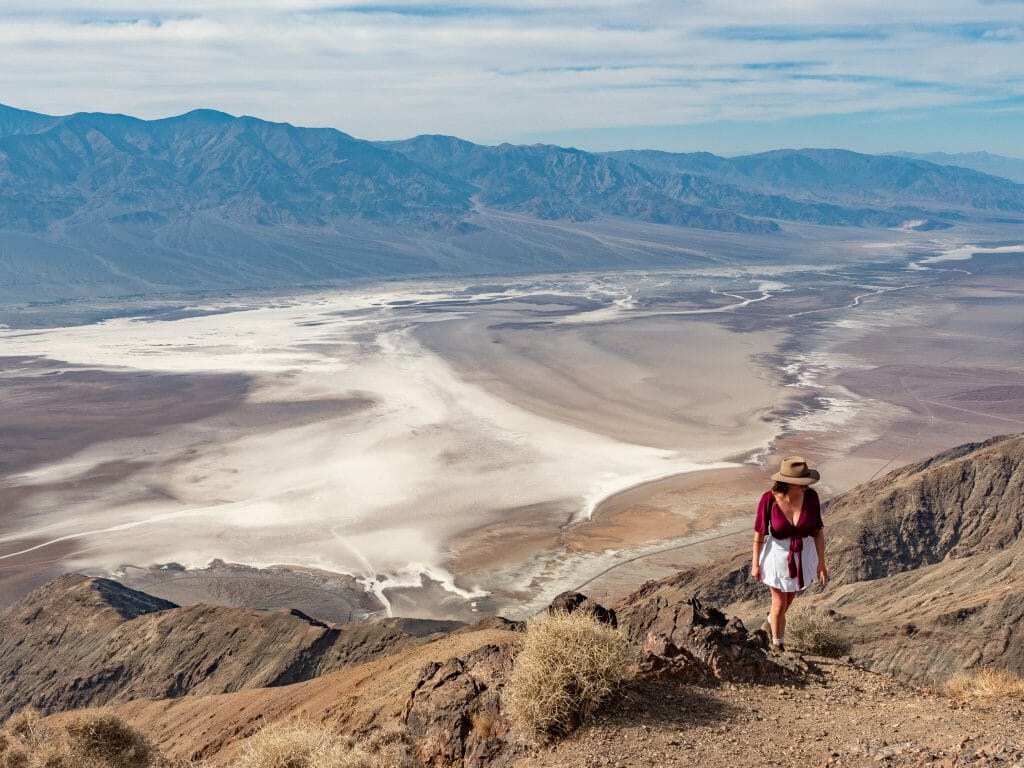
9 | Dante’s View
The grand finale to a spectacular day in Death Valley, divert one final time off the 190 to reach Dante’s Point just in time for sunset.
Situated on the north side of Coffin Peak at 1,699m, you’re far from the reaches of Telescope Peak, but perhaps even better positioned to admire Badwater Basin and its extensive salt flats below.
This is undeniably one of the park’s most jaw-dropping views, and with lots of rocky ledges and informal trails to explore, it’s easy to find a secluded spot to watch the sun sink over the valley. Until next time!

Other great options
- On your way to Death Valley, definitely set aside time to explore Alabama Hills, one of the most beautiful spots in all of California! Read more about what to do & where to camp in this post: THE ULTIMATE 1-DAY ALABAMA HILLS ITINERARY: 11 BEST HIKES & ARCHES (+ EASY CLIMBING AT THE CANDY STORE)
- With more time in Death Valley, you can also hike some of the park’s other tall mountains, like Wildrose Peak or Corkscrew Peak, which are both shorter and easier than Telescope Peak
- Once in Las Vegas, there are heaps of amazing outdoor activities, and Red Rock Canyon is one of the absolute best: THE ULTIMATE 1-DAY RED ROCK CANYON (LAS VEGAS) ITINERARY: 9 BEST HIKES & VIEWPOINTS
Explore more of America’s National Parks
THE ULTIMATE 1-DAY JOSHUA TREE NATIONAL PARK ITINERARY: 9 BEST HIKES & SCRAMBLES (POST-COVID)
THE ULTIMATE 1-DAY VALLEY OF FIRE STATE PARK ITINERARY: 12 BEST HIKES & PHOTO SPOTS
THE ULTIMATE 1-DAY YOSEMITE NATIONAL PARK ITINERARY: 11 BEST VIEWPOINTS & HIKES (POST-COVID)
THE ULTIMATE 1-DAY ARCHES NATIONAL PARK ITINERARY: 17 BEST VIEWPOINTS & HIKES (POST-COVID)
THE ULTIMATE 1-DAY RED ROCK CANYON (LAS VEGAS) ITINERARY: 9 BEST HIKES & VIEWPOINTS