• start here
  • about
  • group trips
  • brooke beyond

  • hiking guides
  • outdoor gear
    • hiking boots
    • hiking backpacks
    • cold-weather layers
    • backpacking tent
    • outdoor sleep system
    • backcountry food
    • day-hike packing list
    • hut-to-hut packing list
    • via ferrata packing list
    • backpacking packing list
    • mountaineering packing list

brooke beyond

Aus + NZ / Australia / New South Wales

Top Illawarra viewpoints and lookouts: Bald Hill, Sea Cliff Bridge & more

7 June 2018

Last Updated on 5 June 2022

Nestled between a lush escarpment and golden beaches from Sydney’s Royal National Park to NSW’s pristine South Coast, the Illawarra region is positively overflowing with natural beauty. Without even a fraction of the tourist popularity of nearby Sydney, though, many people completely overlook this rich and scenic area in favour of more well-known city activities. While there are inarguably hundreds of amazing things to do in Australia’s biggest city, grab the opportunity to explore beyond Bondi Beach and the Opera House— jump on a train, cruise an hour south, and dive into one of the most underrated regions in NSW. Here are some of my very favourite viewpoints in and around Wollongong.

What's in this guide

Toggle
  • Sea Cliff Bridge Lookout
  • Mt Keira Summit Park
  • Sublime Point
  • Mt Kembla Lookout
  • Mt Mitchell Lookout
  • Robertson Knoll
  • Bald Hill
  • *Practical information
    • Getting to/around the Illawarra
    • Where to stay in the Illawarra

Sea Cliff Bridge Lookout

An engineering feat as much as a visual spectacle, Sea Cliff Bridge is one of only 7 off-shore parallel-to-coast bridges in the world, and is also one of the Illawarra’s most impressive landmarks, winding between Clifton and Coalcliff on the scenic Lawrence Hargrave Drive. And, just 30 minutes from Wollongong and less than an hour from the city, it’s an easy morning trip. For the best views, I recommend parking on the south side of the bridge and climbing up into the hills (along a very easily-missed trail) for an aerial view of this beauty.

Read more about finding the trail in this post: FINDING THE SECRET LOOKOUT ABOVE SEA CLIFF BRIDGE
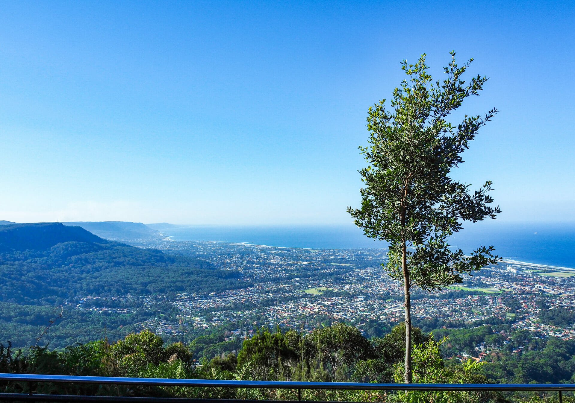
Mt Keira Lookout

Mt Keira Summit Park

Wollongong’s skyline is entirely dominated by a thickly forested escarpment, and one of the best spots to get on top and enjoy views over the region and its many beaches is Mt Keira. Rising just under 500m, it’s not a long or challenging hike to reach the top, but it’s often difficult to follow the trail (especially as it ascends straight up a dry waterfall bed). Still, it’s one of my very favourite walks in the area, departing from the intersection of Robsons Road and Northfields Avenue behind the University. For the less climbing-inclined, Mt Keira Lookout is also easily accessible via car, and a more mellow 5km Ring Track around the summit still offers wonderful views. Bring a picnic to enjoy in the newly improved Summit Park!

Sublime Point

About 20 minutes north of Wollongong in the beachside suburb Austinmer, Sublime Point is another popular lookout over the Illawarra coastline. There’s a short but strenuous hike leading to the viewpoint from Foothills Road, but it’s also possible to drive straight to the top if you’re short on time (or if you don’t feel like breaking a sweat). Save this one for an especially clear day, as any fog and clouds will get trapped between the escarpment and the ocean, obscuring what truly is one of the best views in the area.

Read more about the hike: STAIR-STEPPING UP TO SUBLIME POINT
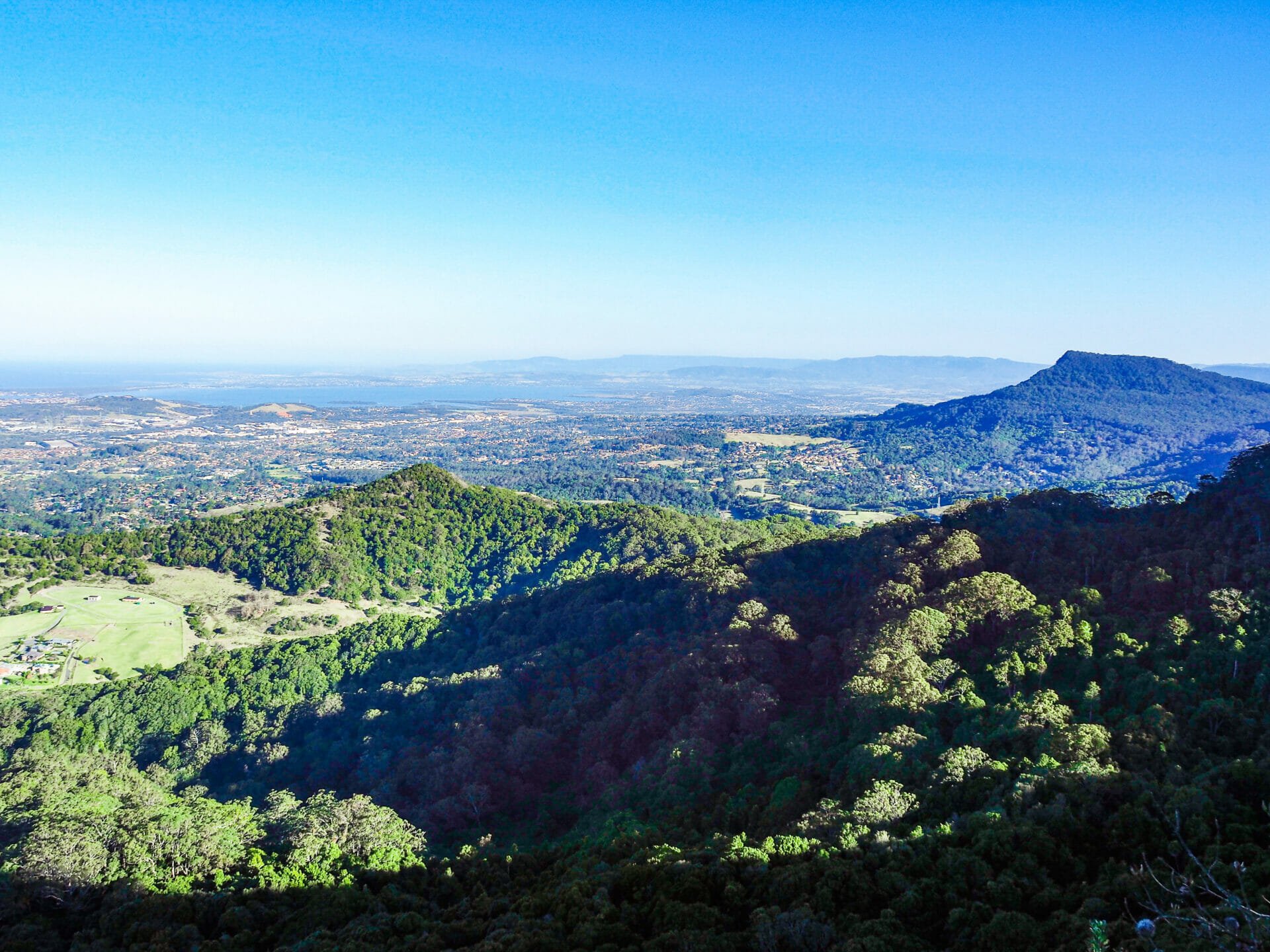
Mt Kembla Lookout

Situated just southwest of Wollongong near Unanderra (and the famous Nan Tien Buddhist Temple), Mt Kembla rises even higher out of the escarpment than nearby Mt Keira. It also offers a slightly different view, looking out over the densely forested Illawarra Escarpment State Conservation Area and Lake Illawarra. Even though there are powerlines running directly across your line of sight, this is still a beautiful spot, and also a popular starting point for several of the short day-hikes around Mt Kembla, including the 6km Ring Track. Navigate straight to this point using Google Maps, but beware of the pothole-dotted road and the surprisingly narrow lanes.
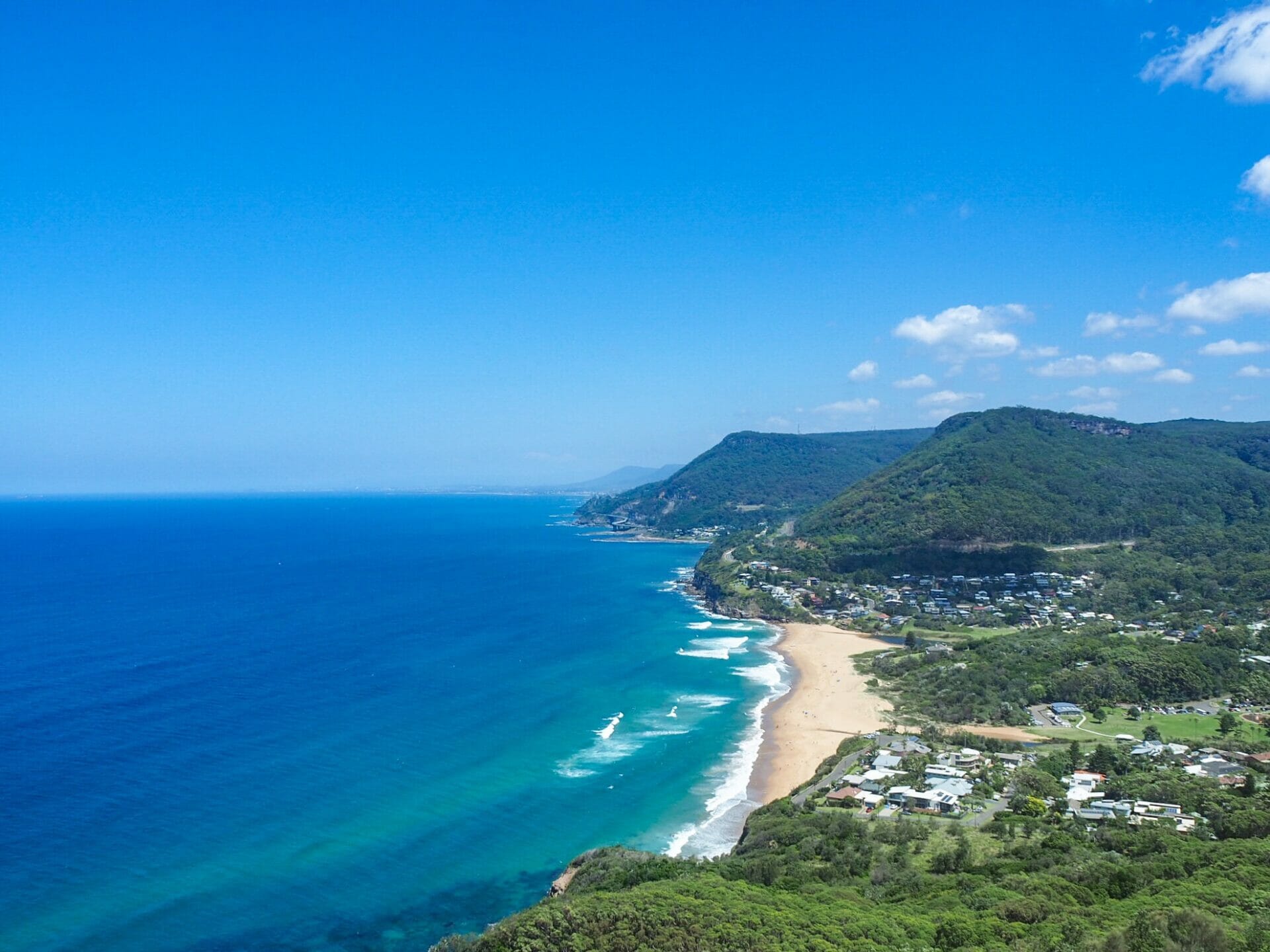
Mt Mitchell Lookout

Named for the indigenous people who originally inhabited this stunning stretch of coastline, Wodi Wodi Track offers spectacular views, the best of which are accessible via a moderately short hike up to Mt Mitchell Lookout. It’s often difficult to see the start of the trail just north of Coalcliff on Lawrence Hargrave Drive (and it’s even more challenging to squeeze your car into the minuscule parking area), but you’ll be well-rewarded if you do. Not only is this one of my all-time favourite views, but it’s a lovely hike that will leave you wanting more of the Illawarra and it’s unassuming beauty. Follow signs from the carpark for “Wodi Wodi Track”, but when the path forks, continue along the “Forest Walk route” for about 1km to reach this stunning viewpoint atop Mt Mitchell.

Looking out over Lake Illawarra and Mt Kembla

Robertson Knoll

For views of both Mt Kembla and Mt Keira, there’s no better spot than this little-known lookout about 3 minutes beyond Mt Keira Summit Park on Harry Graham Drive. The signage is incredibly poor, but you’ll see a small carpark on your left and a little path leading about 100m out to the fenced viewpoint. Just before the wooden boardwalk, veer right into the forest and continue out to the rocks for amazing, unobstructed views of Keira to your left and Lake Illawarra and Kembla to your right. The only thing that could make this spot any better? Hardly anyone knows about it, so it’s unlikely you’ll be joined by another person!
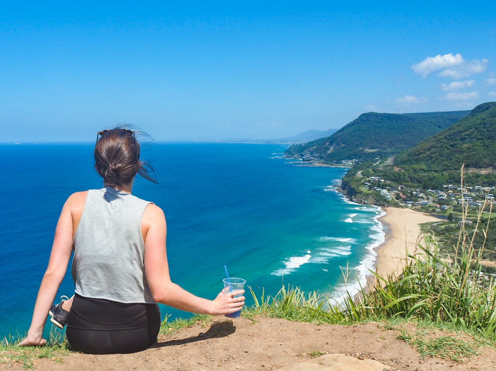
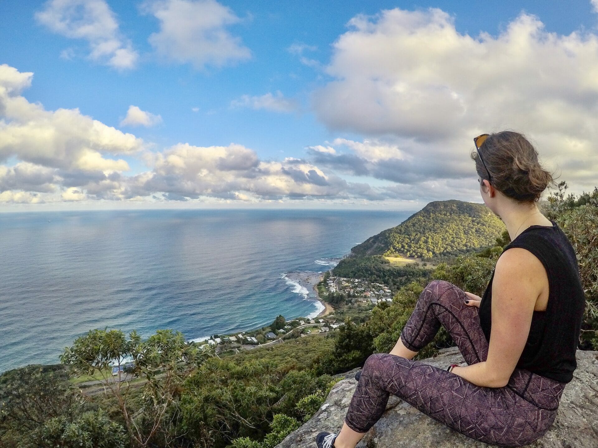
Bald Hill

Even over all the other gorgeous views, stunning beaches, and amazing hikes in the Illawarra, Bald Hill in Stanwell Tops is the first destination on my tour for out-of-towners, every time. On a clear day, the view is simply unrivalled, looking out over the scalloped coastline and the serpentine Sea Cliff Bridge in the distance. For $250, you can actually soar above this postcard view for half an hour on a tandem paraglide! To me, this point shows off the beauty of the region like nowhere else, and it’s absolutely no wonder, sitting on this grassy hill and looking down at the scenery below, why I’ve chosen to make Wollongong my home.

*Practical information

Getting to/around the Illawarra

Many of these lookouts and viewpoints are accessible via public transport from Sydney. The Illawarra/ South Coast train line runs down to Wollongong (and beyond), including stops near Sea Cliff Bridge in Coalcliff, Bald Hill in Stanwell Tops, Mt Keira in North Wollongong, and Sublime Point in Austinmer. Still, the best way to explore this region and get off the beaten path is to drive. You could tackle many of these spots in a single day, but you’ll probably need 2 days to tick everything off, including the bush walks.

Where to stay in the Illawarra

  • Coledale Camping Reserve is definitely the best campsite in the region, located right on the beach near Sea Cliff Bridge.
  • Bulli Beach Tourist Park is only about 20m from the beach, but it’s located right next to a cemetery, so it’s not my first choice.
  • Keiraleagh House has reasonably priced dorm beds in central Wollongong.
  • Novotel Wollongong offers more upscale accommodation right on North Beach, inarguably the nicest part of Wollongong.
TAGS:city guidestravel guides
2 Comments
Share
brooke beyond

Hey, I'm Brooke and I'm obsessed with getting off the beaten path, exploring backcountry gems & travelling beyond the ordinary! I left Australia 5 years ago after finishing a PhD in Biomechanics & have been travelling the world full-time ever since (joined by my life/climbing partner, James). Whether it’s road-tripping through Mexico, climbing alpine peaks in the Andes, scuba diving in the Red Sea, or tackling epic via ferrata in the Dolomites, I hope this blog will inspire your future adventures & help you find wonder in every corner of the globe. xx bb

Leave a Comment Cancel Comment

The Comments

  • Carol Longworth
    22 December 2024

    Can you advise where:
    View Corner, Illawarra, Sydney may be located?
    I have a postcard picture in my Grandad’s scrapbook compiled 120 years ago and would love to replicate the photo today
    Hopefully you can shed some light on its location
    Thanks
    Cazee

    Reply
    • brooke brisbine
      Carol Longworth
      27 March 2025

      Hi Carol, I actually don’t know off the top of my head where that might be… does the photo look similar to any of the viewpoints described in this post or totally different? Any notable landmarks we could use to help place it?

      Reply

You May Also Like

1 March 2018

An afternoon stroll from Rose Bay to Watsons Bay

15 October 2018

Straddie: The ultimate guide to exploring North Stradbroke Island

21 January 2019

The Overland Track: A comprehensive DIY guide to Tasmania’s most iconic multi-day hike

hi, I’m brooke!

I'm obsessed with getting off the beaten path, exploring backcountry gems & travelling beyond the ordinary! I left Australia 5 years ago after finishing a PhD in Biomechanics & have been travelling the world full-time ever since (now joined by my life/climbing partner, James). I hope this blog will inspire your future adventures & help you find wonder in every corner of the globe. xx bb

read my story
currently exploring

currently exploring

mexico

read our gear guides

🥾 hiking boots

🎒 hiking backpacks

🌨️ cold-weather layers

⛺️ backpacking & alpine tents

🛌 sleeping bag & pads

🍪 backcountry food

📸 travel camera gear

✈️ travel clothing

trail guides

summit guides

itineraries

outdoor gear

GPS maps

recent posts

  • Climbing Iztaccíhuatl volcano

    2-week Mexico volcanoes itinerary: climbing Pico de Orizaba, Izta, Malinche & Toluca

    3 June 2025
  • Mexico City: the perfect 5-day itinerary for CDMX

    31 May 2025
  • Climbing Iztaccíhuatl volcano

    Driving in Mexico: essential road trip guide for foreigners

    28 May 2025
  • 10-day Rwanda road trip itinerary: gorillas, volcanoes & Lake Kivu

    25 May 2025
  • 2-week Patagonia itinerary: best of Torres del Paine & Los Glaciares/El Chaltén

    22 May 2025

@brookebeyond_
brooke ✨travel & mountain gal

@brookebeyond_

  • magical moments in the swiss alps 🐄🇨🇭🧀🫐🌺
.
.
.
.
.
#swissalps #switzerland #matterhorn #zermatt #oeschinensee #lucerne #jungfraujoch #grindelwald #swisssummer
  • NEW CUSTOM GPS MAPS!!

✨ shop.brookebeyond.com ✨

Before every single backpacking trip, hut-to-hut & alpine expedition, I spend dozens of hours on @caltopo building a GPS track to help me navigate along the route confidently, especially when venturing off the standard trail (which I nearly always do) 🗺️

And after MANY requests to share my custom routes, I now have 8 super detailed JSON/GPX files that you can use to plan your own epic adventure off the beaten path— navigating right off your smartphone!!!

Available maps:
🇮🇹 Alta Via 2
🇮🇹 Alta Via 4
🇫🇷 Mont Blanc Summit
🇵🇪 Huayhuash Circuit
🇦🇷 Aconcagua Summit
🇺🇸 Teton Crest Trail
🇨🇱 O-Circuit
🇦🇷 Fitz Roy Loop
+ more coming soon!

These maps include detailed route beta with hundreds of waypoints, essential trail stats, alternatives & bailouts, side-trips & summits, all based on my adventurous modifications to these amazing routes! 

They’ve been heavily tested by friends & readers, and I’m confident you won’t find another resource like them 🗺️

✨ shop.brookebeyond.com ✨

ps. If you’ve bought one of my maps this summer (AV2 + AV4 have been SO popular!), I’d love to hear from you!!
  • We took our own engagement photos in the Swiss Alps this summer and here’s how it went 👉🏼

(#8 might just be my personal fave 😂)

ALSO this post is for anyone who’s gotten the (woefully mistaken) impression that I am “naturally photogenic”
  • absolutely one of the most amazing little hikes we did in Switzerlnad this summer (& the competition was stiff) 🤩🏔️🌞🌸

📍Saxer Lücke

GETTING THERE: catch the Frümsen gondola to Staubernkanzel

HIKE: 1hr (2.5km, 250m gain) to this amazing viewpoint

WHEN TO GO: the best lighting is in the afternoon, these photos were taken around 4pm and it just kept getting better!
.
.
.
.
.
#swissalps #switzerland #saxerlücke #swisssummer #alpstein
  • the BEST easy hike in Zermatt 🏔️🥾✨

For spectacular views of the Matterhorn, the enormous Monte Rosa massif, and the Gorner Glacier (as well as 29 peaks over 4,000m!), there’s no better EASY hike than Riffelberg to Gornergrat, accessible via the Gornergrat Railway in Zermatt. 

The hike only takes about 2hrs at a leisurely pace (I did it 7 weeks after knee surgery!), so it’s suitable for families and non-hikers with even a basic level of fitness 🏃🏻‍♀️

🇨🇭 START FROM ZERMATT
- purchase tickets (day-of is fine) from Gornergrat Railway, right across from Zermatt train station

🚞 GORNERGRAT RAILWAY
- tickets from Zermatt to Riffelberg cost 42CHF ($50USD)— there’s no discount for return, so keep it flexible by purchasing one-way
- the train takes the about 25min, sit on the right side for best views!
- when you finish the hike at Gornergrat, buy a one-way ticket back to Zermatt for 66CHF ($80USD)
- save 50% on tickets with the Swiss Half Fare Card— the pass costs 120CHF ($150USD) and lasts for a whole month, it’s almost always worth it!) 

🥾 HIKE DETAILS: RIFFELSEE TO GORNERGRAT
- the route is 5km with 560m elevation gain (entirely uphill)
- the best views of the Matterhorn are around Riffelsee, where several small lakes offer perfect reflections
- near Rotenboden (the train station in between Riffelberg & Gornergrat), there are excellent rocky viewpoints of both Matterhorn and Monta Rosa— it’s easy to find quiet views if you hike around a bit!
- as you get closer to Gornergrat, Monte Rosa and the Gorner Glacier are right in your face
- almost everyone does this hike in reverse (Gornergrat to Riffelberg), I just personally hate hiking downhill— but you can swap if you’d rather descend the entire way!
  • 2 months after knee surgery and barely a week after I stopped walking with a knee brace and cane, I was honestly so proud to be able to do this (objectively very easy) 5km hike with 250m gain— it may not seem like much, but for me, this was a HUGE step forward 🥹

📍 Saxer Lücke, Switzerland 

it’s been an extremely challenging recovery, both physically and mentally… but the milestone moments always fill me with hope that things are indeed getting better ❤️‍🩹

special shoutout to my fiancé/hiking partner/personal cheering squad @slatojc for slowing down with me on the trail and always offering a hand down slippery rocks before I even have to ask
  • it’s another “if it wasn’t so stupid beautiful, I’d never set foot in this country again because it’s bleeding me dry” kinda summer 🇨🇭🌸☀️🏔️🦋✨

(hands up if you feel personally victimised by Swiss prices but you can’t stay away because MOUNTAINS 😭😭)
  • magical summer sunsets in Switzerland ✨
.
.
.
.
#swissalps #stoosridge #swisssummer #sunset
  • BEST EASY HIKES IN SWITZERLAND 🇨🇭❤️‍🩹

just 2 months after knee surgery, I found myself travelling through Switzerland— in search of easy hikes that were actually accessible post-op 🩼 

luckily, there’s hardly a better place in the world for easy hiking than the Swiss Alps!!

so whether you’re recovering from an injury, hiking with older parents/young children, or just a non-hiker who loves an epic view, this short list of HIGH VALUE viewpoints & hikes offer the most spectacular mountain scenery with minimal challenge

💸 BUDGET TIP: buy the Swiss Half Fare Card to save 50% all these gondolas and trains, which can seriously add up!!

- Stoos Ridge: take the Stoosbahn to the little village of Stoos + walk about 15min to the chairlift that can take you all the way up to Fronalpstock— you can walk as little or as much as you want up here, the views are amazing right away
- Riffelsee: take the Gornergrat Railway from Zermatt to Riffelsee + hike 20min to the 2 beautiful alpine lakes (then either hike 1hr up to Gornergrat or catch the train)
- Saxer Lücke: catch a gondola + hike 1hr (2.5km, 250m gain) to this amazing viewpoint— hardest on this list and not suitable for those with extremely limited mobility 
- Kleine Scheidegg: take the train or the gondola from Grindelwald + hike about 20min uphill to the lake
- Jungfraujoch: from Kleine Scheidegg, take the gondola to Jungfraujoch + walk around the viewing platforms
- Trockener Steg: take the gondola from Zermatt + walk 10min from the top of the cable car to the lake for incredible Matterhorn views
- Oeschinensee: 20min walk from the top of the Kandersteg cable car to the lake (bus also available), then you can walk as little or as much as you want around the lake or on the famous Panorama Trail
.
.
.
.
.
#easyhikes #swissalps #matterhorn #jungfraujoch #oeschinensee #stoos #switzerland
follow @brookebeyond_

travel beyond the ordinary

Explore my travel guides, custom itineraries & blog posts with an interactive world map ✨

all destinations

  • magical moments in the swiss alps 🐄🇨🇭🧀🫐🌺
.
.
.
.
.
#swissalps #switzerland #matterhorn #zermatt #oeschinensee #lucerne #jungfraujoch #grindelwald #swisssummer
  • NEW CUSTOM GPS MAPS!!

✨ shop.brookebeyond.com ✨

Before every single backpacking trip, hut-to-hut & alpine expedition, I spend dozens of hours on @caltopo building a GPS track to help me navigate along the route confidently, especially when venturing off the standard trail (which I nearly always do) 🗺️

And after MANY requests to share my custom routes, I now have 8 super detailed JSON/GPX files that you can use to plan your own epic adventure off the beaten path— navigating right off your smartphone!!!

Available maps:
🇮🇹 Alta Via 2
🇮🇹 Alta Via 4
🇫🇷 Mont Blanc Summit
🇵🇪 Huayhuash Circuit
🇦🇷 Aconcagua Summit
🇺🇸 Teton Crest Trail
🇨🇱 O-Circuit
🇦🇷 Fitz Roy Loop
+ more coming soon!

These maps include detailed route beta with hundreds of waypoints, essential trail stats, alternatives & bailouts, side-trips & summits, all based on my adventurous modifications to these amazing routes! 

They’ve been heavily tested by friends & readers, and I’m confident you won’t find another resource like them 🗺️

✨ shop.brookebeyond.com ✨

ps. If you’ve bought one of my maps this summer (AV2 + AV4 have been SO popular!), I’d love to hear from you!!
  • We took our own engagement photos in the Swiss Alps this summer and here’s how it went 👉🏼

(#8 might just be my personal fave 😂)

ALSO this post is for anyone who’s gotten the (woefully mistaken) impression that I am “naturally photogenic”
  • absolutely one of the most amazing little hikes we did in Switzerlnad this summer (& the competition was stiff) 🤩🏔️🌞🌸

📍Saxer Lücke

GETTING THERE: catch the Frümsen gondola to Staubernkanzel

HIKE: 1hr (2.5km, 250m gain) to this amazing viewpoint

WHEN TO GO: the best lighting is in the afternoon, these photos were taken around 4pm and it just kept getting better!
.
.
.
.
.
#swissalps #switzerland #saxerlücke #swisssummer #alpstein
  • the BEST easy hike in Zermatt 🏔️🥾✨

For spectacular views of the Matterhorn, the enormous Monte Rosa massif, and the Gorner Glacier (as well as 29 peaks over 4,000m!), there’s no better EASY hike than Riffelberg to Gornergrat, accessible via the Gornergrat Railway in Zermatt. 

The hike only takes about 2hrs at a leisurely pace (I did it 7 weeks after knee surgery!), so it’s suitable for families and non-hikers with even a basic level of fitness 🏃🏻‍♀️

🇨🇭 START FROM ZERMATT
- purchase tickets (day-of is fine) from Gornergrat Railway, right across from Zermatt train station

🚞 GORNERGRAT RAILWAY
- tickets from Zermatt to Riffelberg cost 42CHF ($50USD)— there’s no discount for return, so keep it flexible by purchasing one-way
- the train takes the about 25min, sit on the right side for best views!
- when you finish the hike at Gornergrat, buy a one-way ticket back to Zermatt for 66CHF ($80USD)
- save 50% on tickets with the Swiss Half Fare Card— the pass costs 120CHF ($150USD) and lasts for a whole month, it’s almost always worth it!) 

🥾 HIKE DETAILS: RIFFELSEE TO GORNERGRAT
- the route is 5km with 560m elevation gain (entirely uphill)
- the best views of the Matterhorn are around Riffelsee, where several small lakes offer perfect reflections
- near Rotenboden (the train station in between Riffelberg & Gornergrat), there are excellent rocky viewpoints of both Matterhorn and Monta Rosa— it’s easy to find quiet views if you hike around a bit!
- as you get closer to Gornergrat, Monte Rosa and the Gorner Glacier are right in your face
- almost everyone does this hike in reverse (Gornergrat to Riffelberg), I just personally hate hiking downhill— but you can swap if you’d rather descend the entire way!
magical moments in the swiss alps 🐄🇨🇭🧀🫐🌺
.
.
.
.
.
#swissalps #switzerland #matterhorn #zermatt #oeschinensee #lucerne #jungfraujoch #grindelwald #swisssummer
magical moments in the swiss alps 🐄🇨🇭🧀🫐🌺
.
.
.
.
.
#swissalps #switzerland #matterhorn #zermatt #oeschinensee #lucerne #jungfraujoch #grindelwald #swisssummer
magical moments in the swiss alps 🐄🇨🇭🧀🫐🌺
.
.
.
.
.
#swissalps #switzerland #matterhorn #zermatt #oeschinensee #lucerne #jungfraujoch #grindelwald #swisssummer
magical moments in the swiss alps 🐄🇨🇭🧀🫐🌺
.
.
.
.
.
#swissalps #switzerland #matterhorn #zermatt #oeschinensee #lucerne #jungfraujoch #grindelwald #swisssummer
magical moments in the swiss alps 🐄🇨🇭🧀🫐🌺
.
.
.
.
.
#swissalps #switzerland #matterhorn #zermatt #oeschinensee #lucerne #jungfraujoch #grindelwald #swisssummer
magical moments in the swiss alps 🐄🇨🇭🧀🫐🌺
.
.
.
.
.
#swissalps #switzerland #matterhorn #zermatt #oeschinensee #lucerne #jungfraujoch #grindelwald #swisssummer
magical moments in the swiss alps 🐄🇨🇭🧀🫐🌺
.
.
.
.
.
#swissalps #switzerland #matterhorn #zermatt #oeschinensee #lucerne #jungfraujoch #grindelwald #swisssummer
magical moments in the swiss alps 🐄🇨🇭🧀🫐🌺
.
.
.
.
.
#swissalps #switzerland #matterhorn #zermatt #oeschinensee #lucerne #jungfraujoch #grindelwald #swisssummer
magical moments in the swiss alps 🐄🇨🇭🧀🫐🌺
.
.
.
.
.
#swissalps #switzerland #matterhorn #zermatt #oeschinensee #lucerne #jungfraujoch #grindelwald #swisssummer
magical moments in the swiss alps 🐄🇨🇭🧀🫐🌺
.
.
.
.
.
#swissalps #switzerland #matterhorn #zermatt #oeschinensee #lucerne #jungfraujoch #grindelwald #swisssummer
magical moments in the swiss alps 🐄🇨🇭🧀🫐🌺
.
.
.
.
.
#swissalps #switzerland #matterhorn #zermatt #oeschinensee #lucerne #jungfraujoch #grindelwald #swisssummer
magical moments in the swiss alps 🐄🇨🇭🧀🫐🌺
.
.
.
.
.
#swissalps #switzerland #matterhorn #zermatt #oeschinensee #lucerne #jungfraujoch #grindelwald #swisssummer
magical moments in the swiss alps 🐄🇨🇭🧀🫐🌺
.
.
.
.
.
#swissalps #switzerland #matterhorn #zermatt #oeschinensee #lucerne #jungfraujoch #grindelwald #swisssummer
@brookebeyond_
@brookebeyond_
•
Follow
magical moments in the swiss alps 🐄🇨🇭🧀🫐🌺 . . . . . #swissalps #switzerland #matterhorn #zermatt #oeschinensee #lucerne #jungfraujoch #grindelwald #swisssummer
1 day ago
View on Instagram |
1/5
NEW CUSTOM GPS MAPS!!

✨ shop.brookebeyond.com ✨

Before every single backpacking trip, hut-to-hut & alpine expedition, I spend dozens of hours on @caltopo building a GPS track to help me navigate along the route confidently, especially when venturing off the standard trail (which I nearly always do) 🗺️

And after MANY requests to share my custom routes, I now have 8 super detailed JSON/GPX files that you can use to plan your own epic adventure off the beaten path— navigating right off your smartphone!!!

Available maps:
🇮🇹 Alta Via 2
🇮🇹 Alta Via 4
🇫🇷 Mont Blanc Summit
🇵🇪 Huayhuash Circuit
🇦🇷 Aconcagua Summit
🇺🇸 Teton Crest Trail
🇨🇱 O-Circuit
🇦🇷 Fitz Roy Loop
+ more coming soon!

These maps include detailed route beta with hundreds of waypoints, essential trail stats, alternatives & bailouts, side-trips & summits, all based on my adventurous modifications to these amazing routes! 

They’ve been heavily tested by friends & readers, and I’m confident you won’t find another resource like them 🗺️

✨ shop.brookebeyond.com ✨

ps. If you’ve bought one of my maps this summer (AV2 + AV4 have been SO popular!), I’d love to hear from you!!
@brookebeyond_
@brookebeyond_
•
Follow
NEW CUSTOM GPS MAPS!! ✨ shop.brookebeyond.com ✨ Before every single backpacking trip, hut-to-hut & alpine expedition, I spend dozens of hours on @caltopo building a GPS track to help me navigate along the route confidently, especially when venturing off the standard trail (which I nearly always do) 🗺️ And after MANY requests to share my custom routes, I now have 8 super detailed JSON/GPX files that you can use to plan your own epic adventure off the beaten path— navigating right off your smartphone!!! Available maps: 🇮🇹 Alta Via 2 🇮🇹 Alta Via 4 🇫🇷 Mont Blanc Summit 🇵🇪 Huayhuash Circuit 🇦🇷 Aconcagua Summit 🇺🇸 Teton Crest Trail 🇨🇱 O-Circuit 🇦🇷 Fitz Roy Loop + more coming soon! These maps include detailed route beta with hundreds of waypoints, essential trail stats, alternatives & bailouts, side-trips & summits, all based on my adventurous modifications to these amazing routes! They’ve been heavily tested by friends & readers, and I’m confident you won’t find another resource like them 🗺️ ✨ shop.brookebeyond.com ✨ ps. If you’ve bought one of my maps this summer (AV2 + AV4 have been SO popular!), I’d love to hear from you!!
3 days ago
View on Instagram |
2/5
We took our own engagement photos in the Swiss Alps this summer and here’s how it went 👉🏼

(#8 might just be my personal fave 😂)

ALSO this post is for anyone who’s gotten the (woefully mistaken) impression that I am “naturally photogenic”
We took our own engagement photos in the Swiss Alps this summer and here’s how it went 👉🏼

(#8 might just be my personal fave 😂)

ALSO this post is for anyone who’s gotten the (woefully mistaken) impression that I am “naturally photogenic”
We took our own engagement photos in the Swiss Alps this summer and here’s how it went 👉🏼

(#8 might just be my personal fave 😂)

ALSO this post is for anyone who’s gotten the (woefully mistaken) impression that I am “naturally photogenic”
We took our own engagement photos in the Swiss Alps this summer and here’s how it went 👉🏼

(#8 might just be my personal fave 😂)

ALSO this post is for anyone who’s gotten the (woefully mistaken) impression that I am “naturally photogenic”
We took our own engagement photos in the Swiss Alps this summer and here’s how it went 👉🏼

(#8 might just be my personal fave 😂)

ALSO this post is for anyone who’s gotten the (woefully mistaken) impression that I am “naturally photogenic”
We took our own engagement photos in the Swiss Alps this summer and here’s how it went 👉🏼

(#8 might just be my personal fave 😂)

ALSO this post is for anyone who’s gotten the (woefully mistaken) impression that I am “naturally photogenic”
We took our own engagement photos in the Swiss Alps this summer and here’s how it went 👉🏼

(#8 might just be my personal fave 😂)

ALSO this post is for anyone who’s gotten the (woefully mistaken) impression that I am “naturally photogenic”
We took our own engagement photos in the Swiss Alps this summer and here’s how it went 👉🏼

(#8 might just be my personal fave 😂)

ALSO this post is for anyone who’s gotten the (woefully mistaken) impression that I am “naturally photogenic”
We took our own engagement photos in the Swiss Alps this summer and here’s how it went 👉🏼

(#8 might just be my personal fave 😂)

ALSO this post is for anyone who’s gotten the (woefully mistaken) impression that I am “naturally photogenic”
We took our own engagement photos in the Swiss Alps this summer and here’s how it went 👉🏼

(#8 might just be my personal fave 😂)

ALSO this post is for anyone who’s gotten the (woefully mistaken) impression that I am “naturally photogenic”
@brookebeyond_
@brookebeyond_
•
Follow
We took our own engagement photos in the Swiss Alps this summer and here’s how it went 👉🏼 (#8 might just be my personal fave 😂) ALSO this post is for anyone who’s gotten the (woefully mistaken) impression that I am “naturally photogenic”
6 days ago
View on Instagram |
3/5
@brookebeyond_
@brookebeyond_
•
Follow
absolutely one of the most amazing little hikes we did in Switzerlnad this summer (& the competition was stiff) 🤩🏔️🌞🌸 📍Saxer Lücke GETTING THERE: catch the Frümsen gondola to Staubernkanzel HIKE: 1hr (2.5km, 250m gain) to this amazing viewpoint WHEN TO GO: the best lighting is in the afternoon, these photos were taken around 4pm and it just kept getting better! . . . . . #swissalps #switzerland #saxerlücke #swisssummer #alpstein
7 days ago
View on Instagram |
4/5
the BEST easy hike in Zermatt 🏔️🥾✨

For spectacular views of the Matterhorn, the enormous Monte Rosa massif, and the Gorner Glacier (as well as 29 peaks over 4,000m!), there’s no better EASY hike than Riffelberg to Gornergrat, accessible via the Gornergrat Railway in Zermatt. 

The hike only takes about 2hrs at a leisurely pace (I did it 7 weeks after knee surgery!), so it’s suitable for families and non-hikers with even a basic level of fitness 🏃🏻‍♀️

🇨🇭 START FROM ZERMATT
- purchase tickets (day-of is fine) from Gornergrat Railway, right across from Zermatt train station

🚞 GORNERGRAT RAILWAY
- tickets from Zermatt to Riffelberg cost 42CHF ($50USD)— there’s no discount for return, so keep it flexible by purchasing one-way
- the train takes the about 25min, sit on the right side for best views!
- when you finish the hike at Gornergrat, buy a one-way ticket back to Zermatt for 66CHF ($80USD)
- save 50% on tickets with the Swiss Half Fare Card— the pass costs 120CHF ($150USD) and lasts for a whole month, it’s almost always worth it!) 

🥾 HIKE DETAILS: RIFFELSEE TO GORNERGRAT
- the route is 5km with 560m elevation gain (entirely uphill)
- the best views of the Matterhorn are around Riffelsee, where several small lakes offer perfect reflections
- near Rotenboden (the train station in between Riffelberg & Gornergrat), there are excellent rocky viewpoints of both Matterhorn and Monta Rosa— it’s easy to find quiet views if you hike around a bit!
- as you get closer to Gornergrat, Monte Rosa and the Gorner Glacier are right in your face
- almost everyone does this hike in reverse (Gornergrat to Riffelberg), I just personally hate hiking downhill— but you can swap if you’d rather descend the entire way!
@brookebeyond_
@brookebeyond_
•
Follow
the BEST easy hike in Zermatt 🏔️🥾✨ For spectacular views of the Matterhorn, the enormous Monte Rosa massif, and the Gorner Glacier (as well as 29 peaks over 4,000m!), there’s no better EASY hike than Riffelberg to Gornergrat, accessible via the Gornergrat Railway in Zermatt. The hike only takes about 2hrs at a leisurely pace (I did it 7 weeks after knee surgery!), so it’s suitable for families and non-hikers with even a basic level of fitness 🏃🏻‍♀️ 🇨🇭 START FROM ZERMATT - purchase tickets (day-of is fine) from Gornergrat Railway, right across from Zermatt train station 🚞 GORNERGRAT RAILWAY - tickets from Zermatt to Riffelberg cost 42CHF ($50USD)— there’s no discount for return, so keep it flexible by purchasing one-way - the train takes the about 25min, sit on the right side for best views! - when you finish the hike at Gornergrat, buy a one-way ticket back to Zermatt for 66CHF ($80USD) - save 50% on tickets with the Swiss Half Fare Card— the pass costs 120CHF ($150USD) and lasts for a whole month, it’s almost always worth it!) 🥾 HIKE DETAILS: RIFFELSEE TO GORNERGRAT - the route is 5km with 560m elevation gain (entirely uphill) - the best views of the Matterhorn are around Riffelsee, where several small lakes offer perfect reflections - near Rotenboden (the train station in between Riffelberg & Gornergrat), there are excellent rocky viewpoints of both Matterhorn and Monta Rosa— it’s easy to find quiet views if you hike around a bit! - as you get closer to Gornergrat, Monte Rosa and the Gorner Glacier are right in your face - almost everyone does this hike in reverse (Gornergrat to Riffelberg), I just personally hate hiking downhill— but you can swap if you’d rather descend the entire way!
2 weeks ago
View on Instagram |
5/5

  • start here
  • about
  • group trips
  • destinations
  • hiking guides
  • outdoor gear
  • custom GPS maps
  • privacy
  • contact

COPYRIGHT © 2025 BROOKE BEYOND. TRAVEL BEYOND THE ORDINARY. Site Powered by Pix & Hue.


Loading Comments...