• start here
  • about
  • group trips
  • brooke beyond

  • hiking guides
  • outdoor gear
    • hiking boots
    • hiking backpacks
    • cold-weather layers
    • backpacking tent
    • outdoor sleep system
    • backcountry food
    • day-hike packing list
    • hut-to-hut packing list
    • via ferrata packing list
    • backpacking packing list
    • mountaineering packing list

brooke beyond

Canada

Complete Mt Assiniboine Provincial Park packing list

27 April 2025

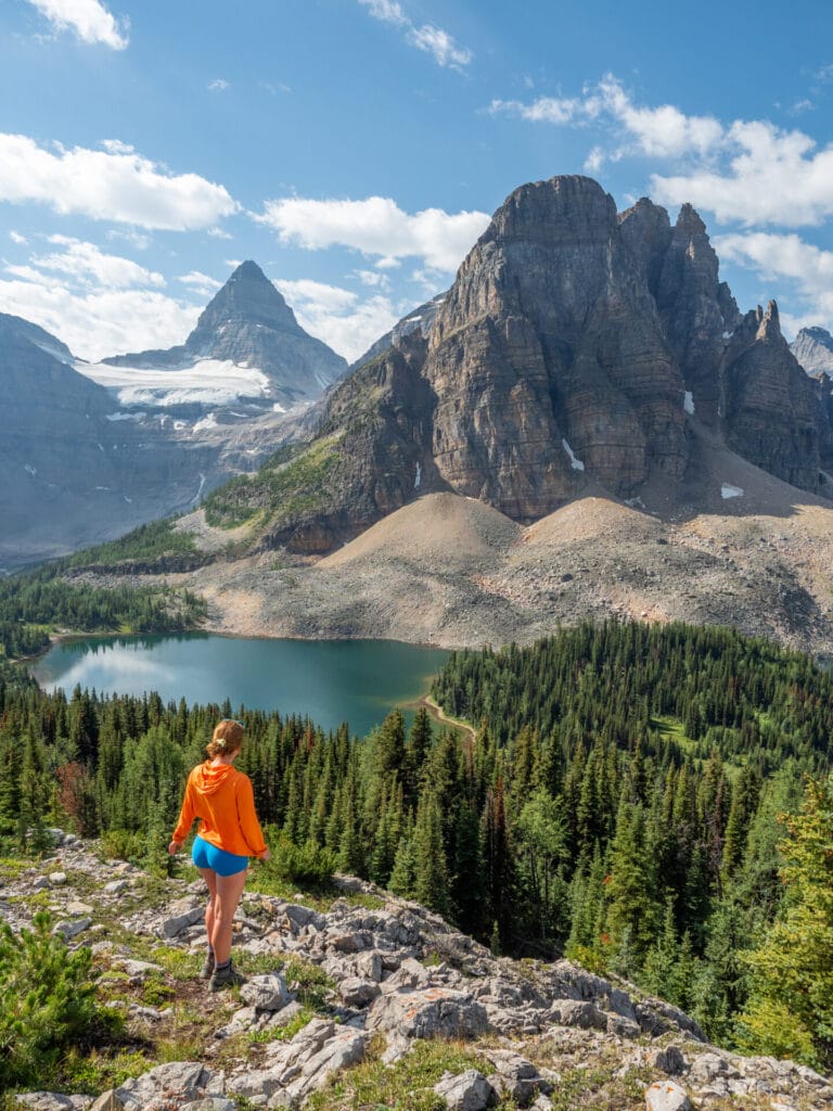
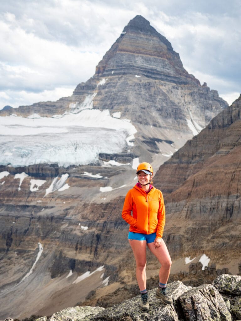
Tucked away in the Canadian Rockies, Mt Assiniboine Provincial Park delivers one of the most spectacular backcountry adventures in North America— linking multi-day hiking, alpine scrambles, and technical mountaineering into one unforgettable journey. From the wildflower meadows around Magog Lake to the iconic pyramid summit of Mt Assiniboine, you’ll be carrying everything you need across 7–10 days of rugged, remote terrain.

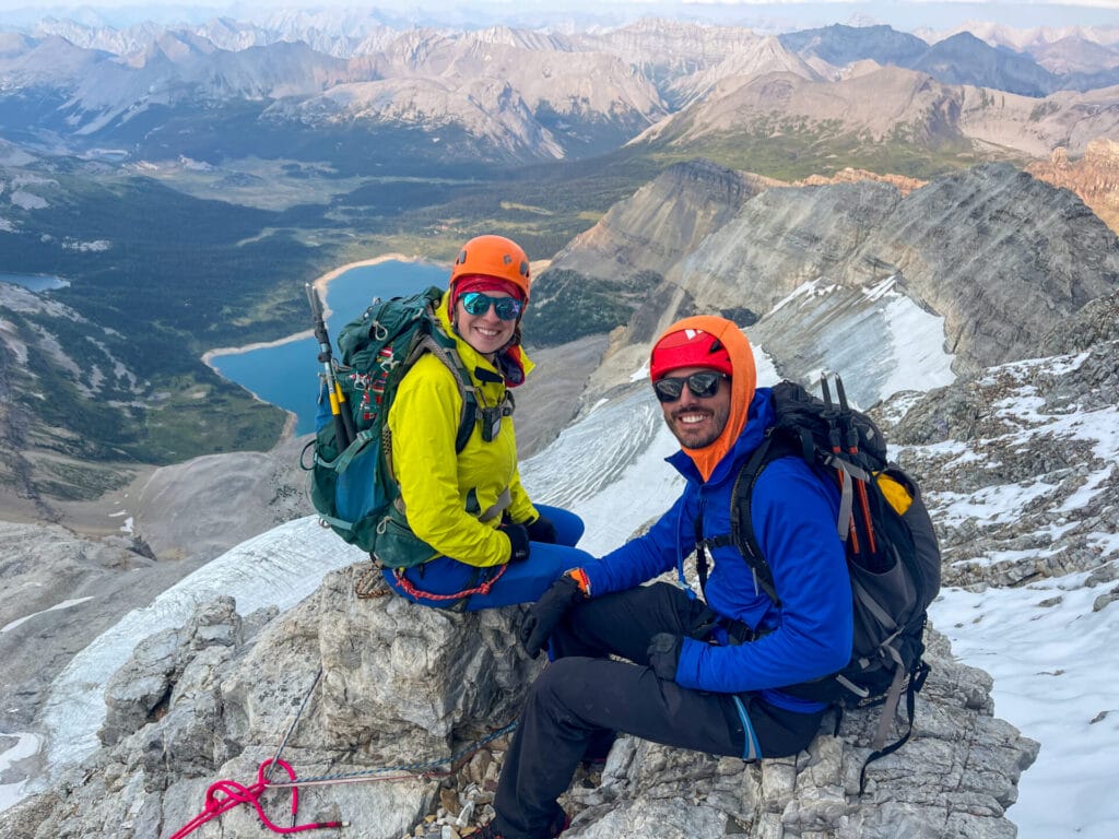
We completed this full Assiniboine traverse— hiking from Sunshine Village, summiting Nub Peak, Sunburst Peak, and Wonder Peak, sleeping at the legendary Hind Hut, and finally climbing Mt Assiniboine via the North Ridge— in one incredible expedition in August 2024. This post breaks down exactly what we packed for this route, with real-world insights to help you build the perfect gear list for your own multi-day mountaineering adventure in Mt Assiniboine Provincial Park.

This post contains affiliate links, which means I may earn a small commission if you purchase something I recommend, at no extra cost to you. I ONLY recommend gear that I personally use (or that James uses) and that we genuinely LOVE— your support helps keep this site going and the adventures rolling!

What's in this guide

Toggle
  • Mt Assiniboine packing list
    • Climbing gear
    • Safety & navigation
    • Camping gear
    • Camp kitchen, water storage & food
    • What to wear in Mt Assiniboine: top + bottom layers
    • What to wear in Mt Assiniboine: head, hands & feet

Check out my outdoor gear guides for the best:

hiking boots
hiking backpacks
cold-weather layers
backpacking tents
outdoor sleep system
backcountry food
camera gear

Mt Assiniboine packing list

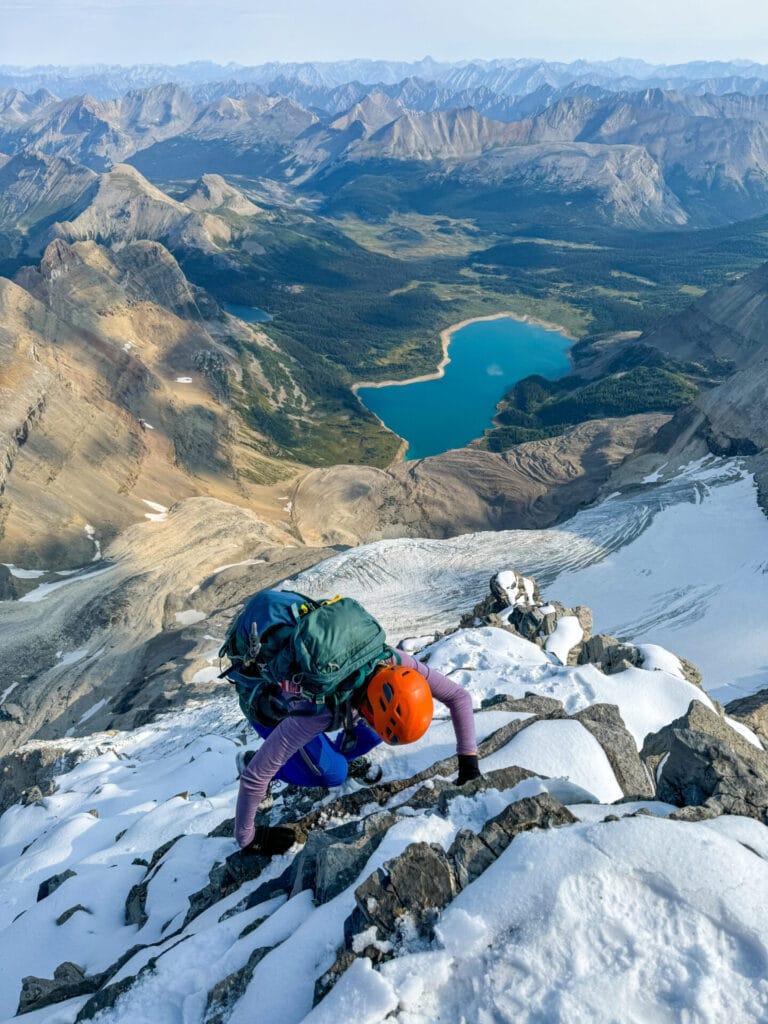
This Assiniboine expedition combines everything: a long 30km trail approach, multi-day backcountry camping, and four major summits ranging from Class 2 alpine scrambles to low 5th class trad climbing. You’ll need to be prepared for trail hiking, off-trail alpine navigation, loose scrambling, and technical roped climbing— plus carrying a full backcountry camp setup and all your personal mountaineering gear.

The typical weather window for this trip is mid-July through early September, when most lower trails are snow-free but lingering snowfields, sudden storms, freezing nights, and even early snowfall at elevation are still real risks. Expect a heavier starting pack (~23kg/50lbs) and prioritise gear that balances weight, durability, and versatility to move efficiently and safely across this spectacular wilderness.

🏔️ Check out my Mt Assiniboine Guide for the custom 7-day adventure itinerary, summit logistics & real-world tips based on our 10-day backpacking trip in August 2024!

CLIMBING GEAR
⭐️ backpack (50-75L): Osprey Aura AG 50 (women’s) / Atmos AG 65 (men’s)
⭐️ mountaineering boots: La Sportiva Trango Tech Leather GTX Boots (women’s) / (men’s)
⭐️ helmet: Black Diamond Half Dome Helmet (women’s) / (men’s)
⭐️ harness: Black Diamond Couloir Harness
⭐️ rope: Black Diamond 8.9mm Dry Rope (40m)
⭐️ minimal alpine rack
⭐️ trekking poles: Black Diamond Trail Trekking Poles

SAFETY & NAVIGATION
⭐️ PLB/SOS: Garmin InReach Mini 2
⭐️ GPS: CalTopo app on mobile & Garmin fenix 7X Pro Watch
⭐️ First Aid Kit: Adventure Medical Kits Backpacker
⭐️ headlamp: Black Diamond Spot 400-R
⭐️ powerbank: VRURC Portable Charger with Built-in Cables, 10000mAh
⭐️ solar charger: BigBlue 28W Solar Charger

CAMPING GEAR
⭐️ backpacking tent: Nemo Dragonfly OSMO 3P (best for 2 people)
⭐️ sleeping bag: Sea to Summit Spark 0
⭐️ sleeping pad: Therm-a-Rest NeoAir XLite NXT Sleeping Pad
⭐️ camp pillow: Sea to Summit Aeros Premium
⭐️ camp shoes: Teva Original
⭐️ toiletries + bathroom bits

CAMP KITCHEN, WATER STORAGE & FOOD
⭐️ camp stove (+ fuel): Jetboil Zip
⭐️ cup: Frontier Ultralight Collapsible Cup + spoon: Toaks Titanium Long Handle Spoon
⭐️ water filter: Katadyn BeFree 1.0L Water Filter
⭐️ water reservoir: HydraPak Seeker 2L
⭐️ 2x water bottles: Nalgene Wide Mouth
⭐️ electrolytes: Liquid IV
⭐️ freeze-dried meals + snacks: see my complete guide to backcountry food

TOP + BOTTOM LAYERS
⭐️ 2x sports bras + underwear
⭐️ sun shirt: Arc’teryx Taema Hoody (women’s) / Cormac Hoody (men’s)
⭐️ wool base layer: Smartwool Classic Thermal Base Layer Top (women’s) / (men’s)
⭐️ heavyweight fleece mid-layer: Arc’teryx Kyanite Zip Neck Top (women’s) / Rho HV Zip Neck Top (men’s)
⭐️ synthetic insulation: Arc’teryx Atom Hoody (women’s) / (men’s)
⭐️ shell jacket: Arc’teryx Beta SL Jacket (women’s) / (men’s)
⭐️ hiking shorts: Lululemon Align shorts
⭐️ fleece mid-layer bottoms: Arc’teryx Kyanite Base Layer Bottoms (women’s) / (men’s)
⭐️ soft shell pants: Arc’teryx Gamma Pants (women’s) / (men’s)

HEAD, HANDS & FEET
⭐️ sun hat: Arc’teryx Gamma 5-Panel Cap
⭐️ glacier glasses: Julbo Vermont
⭐️ neck gaiter: Buff Original
⭐️ lightweight hiking gloves: Outdoor Research Trail Mix Gloves (women’s) / (men’s)
⭐️ liner socks: Injinji Liner Crew
⭐️ boot socks: Darn Tough Hiker Micro Crew Cushion Socks (women’s) / (men’s)

Near the summit of Mt Assiniboine

Climbing gear

Assiniboine demands a versatile system: you’ll be hiking 30km+ of trail each way into the park, scrambling off-trail, and climbing steep alpine ridges to windy summits. Every item here needs to function across a range of mountain modalities, with a major emphasis on comfort, durability, and lightweight performance.


backpack (50-75L): Osprey Aura AG 50 (Women’s) / Atmos AG 50 (Men’s)

I used my Osprey Aura AG 50 for our 10-day Assiniboine trip, and while it technically fit everything, I definitely maxed it out. For most people, a 65L+ pack will be far more comfortable and practical, especially if you’re carrying group gear.


Alta Via 1 2 4 Packing List- Italian Dolomites

mountaineering boots: La Sportiva Trango Tech Leather GTX Boots (women’s) / (men’s)

My lightweight mountaineering were perfect for this trip: comfortable enough for trail mileage but stiff and supportive enough for scrambling and climbing.


Alta Via 1 2 4 Packing List- Italian Dolomites

helmet: Black Diamond Half Dome Helmet (women’s) / (men’s)

Essential for rockfall protection while scrambling loose alpine routes and climbing technical pitches. Even if you’re skipping Mt Assiniboine, you’ll need a helmet for all the scramble summits!


harness: Black Diamond Couloir Harness

Lightweight, compact, and easy to wear over bulky layers and boots. This is a great alpine harness for Assiniboine— I wore a bulkier crag harness, but this is what James brought and we agreed it was the better choice. Remember to add an ATC and auto-block!


rope: Black Diamond 8.9mm Dry Rope (40m)

A 30-40m rope is needed for the low-Class 5 pitches on Mt Assiniboine, but the rappel works best with a 60-70m rope. We used 2x 35m ropes to lead up to the summit block, then tied together for a double-strand rappel on descent.
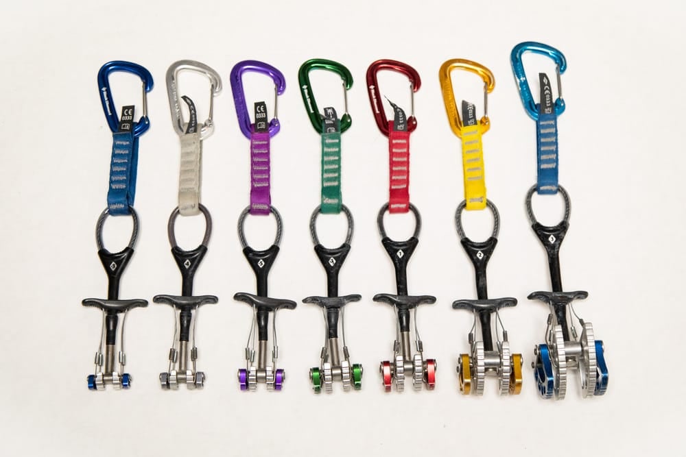

minimal alpine rack

There are 2 sections of low-5th Class climbing on Assiniboine that sometimes require protection (or are free-climbed). During our summit, we had a ton of snow and ice on the route, so we were grateful to have protection, though I originally hadn’t wanted to bring it! This can vary widely, but a good starting point:

  • Cams: Single set of cams from 0.5 to 3in
  • Nuts: Full set of stoppers
  • Alpine Draws: 4–6 extendable alpine draws (60 cm slings with wiregate carabiners)
  • Slings: A few extra 60 cm and 120 cm slings for natural protection and anchor building

Alta Via 1 2 4 Packing List- Italian Dolomites

trekking poles: Black Diamond Trail Trekking Poles

I used these every day on the trail and they were especially helpful on long descents and uneven terrain with a full pack. I collapsed and stashed them for the summit scrambles, but they saved my knees on the way down!


Garmin In-Reach communication for soloing Aconcagua
Garmin In-Reach Mini 2 communication & emergency device–essential!!

Safety & navigation

From storm navigation to summit safety, it’s worth packing a few extra tools to stay prepared on a long backcountry trip into Mt Assiniboine Provincial Park.


Alta Via 1 2 4 Packing List- Italian Dolomites

PLB/SOS: Garmin InReach Mini 2

A Personal Locator Beacon (PLB) is your lifeline in the outdoors and I NEVER go hiking without my Garmin InReach Mini 2, which allows me to send messages, get weather updates, track location, and place an SOS call in an emergency, even without phone service. It does require a subscription (starting at $12/month), but it’s worth every cent and has literally saved both of my parents’ lives in the backcountry!


Alta Via 1 2 4 Packing List- Italian Dolomites

GPS: CalTopo app on mobile

The absolute best GPS resource is the smartphone you already own, paired with a reliable, low-cost GPS mapping app that allows you to access detailed offline Topo maps and navigate via GPS satellites, even without mobile service.

My go-to is CalTopo, which costs just $20/year and is by far the most feature-rich, affordable, and accurate mapping tool out there.

🗺️ I built a custom Mt Assiniboine GPS map with daily tracks based on my adventure itinerary, dozens of waypoints + summits, and other essential navigational information to help you stay on track. Download here.


First Aid Kit: Adventure Medical Kits Backpacker

All the usual essentials:
• a mix of NSAIDs (ibuprofen, naproxen)
• antihistamines (Claritin for allergies, Benadryl for bites/stings)
• a small selection of stomach meds (like Imodium or Pepto tabs)
• a roll of KT tape (insanely versatile for everything from blisters to rolled ankles)
• alcohol wipes, antiseptic, a few large gauze pads, and blister plasters like Compeed


Alta Via 1 2 4 Packing List- Italian Dolomites

headlamp: Black Diamond Spot 400-R

A bright, rechargeable headlamp is essential for evenings around camp and (hopefully not) late nights on the trail. Lightweight and easy to stash in a top pocket for quick access!


Alta Via 1 2 4 Packing List- Italian Dolomites

powerbank: VRURC Portable Charger with Built-in Cables, 10000mAh

I used my phone constantly for navigation and photos, plus needed power for my inReach and headlamp. I carried a 10,000mAh powerbank and a solar charger, which was enough to stay topped up for 10 days in the backcountry.


solar charger: BigBlue 28W Solar Charger

On multi-day trips with no access to power, a lightweight solar charger can be a great alternative to carrying multiple powerbanks. I definitely recommend one for any trip into Mt Assiniboine to top up your phone, inReach, and headlamp during sunny lunch breaks— just enough to stay comfortably powered without the extra weight.

👉🏼 Want to see how we capture photos and videos on our adventures? Peak inside our camera bag!
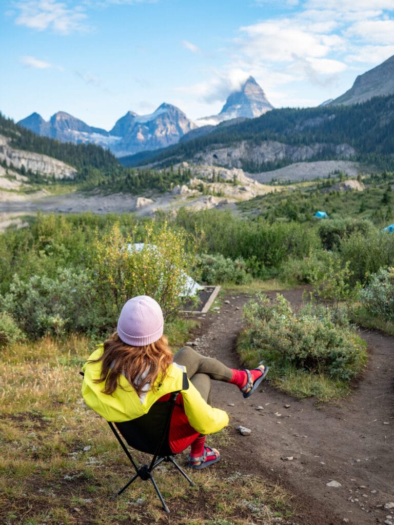

Lake og Campground

Camping gear

This Assiniboine expedition follows a semi-basecamp style: you’ll establish longer stays at Lake Og (1–2 nights), Magog Lake (3–4 nights), and Hind Hut (2 nights), with a final night at Porcupine Campground before hiking out. You’ll be moving between camps every few days, so your sleep system needs to be lightweight for carrying, but durable and warm enough for multi-day use in alpine conditions.

I wrote two super detailed guides to help you choose the best backcountry camping setup based on a decade of international, multi-day backpacking experience everywhere from Patagonia to the Peruvian Andes to the Great Ocean Walk on Australia’s southern coast!

👉🏼 How to choose the best backpacking or alpine tent for your next adventure

👉🏼 How to choose the best outdoor sleep system: sleeping bags, sleeping pads & camp pillows


backpacking tent: Big Agnes Tiger Wall UL2 (solo hikers) or Nemo Dragonfly OSMO 3P (for 2 sharing)

A lightweight 3-season backpacking tent is perfect for Mt Assiniboine Provincial Park in summer. The Nemo Dragonfly OSMO 3P is perfect for 2 people sharing (we love being able to fit all of our mountaineering gear inside the tent).


sleeping bag: Sea to Summit Spark 0

A 0°F (-18°C) sleeping bag was more than enough for summer nights— probably warmer than necessary, but I appreciated the extra insulation on cooler mornings since I’m such a cold sleeper.


sleeping pad: Therm-a-Rest NeoAir XLite NXT Sleeping Pad

For backpacking, I always use an inflatable insulated pad with a high R-value (above 4). This is my favourite ultralight pad, but it pays to be honest with yourself— if you need a beefy pad to get good sleep, it will be worth the weight for you to upgrade to something like the Big Agnes Rapide SL that James uses.


camp pillow: Sea to Summit Aeros Premium

A camp pillow is a small, lightweight addition to your sleep system that is guaranteed to improve your sleep compared to stuffing clothes in a pillow.


camp chair (luxury item!): REI Co-op Flexlite Air

Not essential, but very nice to have—especially if you’ll be spending long evenings in camp. This chair weighs under 450g and packs small enough to justify the comfort on relaxed trips, so I loved having it for Lake Magog.


camp shoes: Teva Original

Easy to slip on after hiking boots, great for giving feet a breather, and worked well for setting up camp and short bathroom walks.


toiletries + bathroom bits

Toothbrush, toothpaste, hairbrush, deodorant, medications, contact solution… whatever you need to stay clean and comfortable for up to 10 days on the trail!

There are simple pit toilets at the campsites, but definitely still bring extra TP and hand sanitiser!


Sunburst and Mt Assiniboine

Camp kitchen, water storage & food

You’ll be carrying all your own food and kitchen gear for 7–10 days on this trip, with no resupply points once you leave Sunshine Village (except for baked goods occasionally for sale at the Lodge).

Although this is bear country, every designated campground along the route is equipped with bear lockers, so you won’t need to bring a bear canister or Ursack. However, you’ll still need to follow strict bear-safe food storage and handling practices at all times.

👉🏼 Confused about what food to pack?! How to pack food for multi-day backcountry adventures: our tips for maximising calories & minimising weight


camp stove (+ fuel): Jetboil Zip

Simple, reliable, and boils water fast—perfect for freeze-dried meals and hot cocoa at camp without adding much weight to your system.


mess kit + cutlery: Sea to Summit Frontier Ultralight Collapsible 4-Piece Dinnerware Set

At the very minimum, your mess kit should contain a spoon and cup; at most, it might extend to a bowl and fork.


water filter: Katadyn BeFree 1.oL Water Filter

A compact squeeze filter is the easiest way to make clean drinking water from the streams and lakes near each campground.


water reservoir: HydraPak Seeker 2L

On top of your filter and your water bottle, backpacking trips call for a water reservoir— a lightweight, collapsible container used to haul dirty water from a stream or lake back to camp. Use it to fill pots for dinner or filter into bottles without crouching over a creek for 10 minutes! Lightweight, packable, and seriously practical when you’re dry camping or need to filter for multiple people.


water bottle or bladder: Nalgene Wide Mouth or Osprey Hydraulics Reservoir 2L

I personally don’t like bladders on overnight trips since they can be especially challenging to fill when you’re filtering water (and the consequences of leakage can be catastrophic if it soaks your sleeping bag), so instead I pack 1-2 standard Nalgene bottles. As you like it!


electrolytes

If you’re sweating a lot and/or gaining serious elevation, drinking plain water simply isn’t enough to replenish the salts your body is losing. I recommend adding electrolyte tablets to at least half of the water you’re drinking during a multi-day backpacking trip to help with performance and hydration!

Best overall: Liquid IV


freeze-dried meals + snacks

Pack whatever you need for 7-10 days on the trail!

Favourite brands: Peak Refuel; Packit Gourmet; Backpacker’s Pantry; Real Turmat (European brand)

👉🏼 Check out this post for a breakdown on how we pack backcountry food for multi-day backpacking trips


On the summit of Sunburst Peak, Mt Assiniboine in background

What to wear in Mt Assiniboine: top + bottom layers

The weather in Assiniboine Provincial Park can swing from t-shirt hiking to full winter layering in a matter of hours. You’ll need a versatile layering system that can handle high-output trail days, exposed alpine scrambling, and summer storms— all packed light enough for 7–10 days on the move.

👉🏼 Need help building a layering system that works for any trip? Read my outdoor layering guide for tips on choosing base layers, insulation, and outer shells.


2x sports bras + underwear

I’m not going to tell you what undergarments to pack, but just consider you’ll be doing a lot of sweating in the summer heat! I hiked in a sports bra and shorts every day, including for my scrambles.


hiking shirt: Arc’teryx Taema Crew Shirt (women’s) / Cormac Crew Shirt (men’s)

I’d suggest bringing just one shirt and washing it in the lake partway through the trip, if needed!


sun shirt: Arc’teryx Taema Hoody (women’s) / Cormac Hoody (men’s)

Breathable, quick-drying, and UPF-rated to protect from the intense afternoon sun. This is a great daily layer in the Rockies!


wool base layer: Smartwool Classic Thermal Base Layer Top (women’s) / (men’s)

This was my base layer for sleeping; I never wore it for hiking in an attempt to keep as clean as possible.


Arc'teryx rho kyanite

heavyweight fleece mid-layer: Arc’teryx Kyanite Zip Neck Top (women’s) / Rho Heavyweight Zip Neck Top (men’s)

I used this occasionally in the early morning or during side summit scrambles. It mostly stayed in my pack, but was a nice mid-layer to have when the wind picked up.


synthetic insulation: Arc’teryx Atom Hoody (women’s) / (men’s)

Perfect for camp comfort and summit day warmth, I used this jacket every single day as my outer layer!


mid-weight down jacket: Arc’teryx Cerium Hoody (women’s) / (men’s)

Best as a camp layer for added warmth in the evenings, especially at chilly Hind Hut!


shell jacket: Arc’teryx Beta SL Jacket (women’s) / (men’s)

Lightweight, packable, and absolutely worth carrying in the Rockies— where a bluebird morning can still end in a 4pm thunderstorm.


hiking shorts: Lululemon Align shorts

I’m a fan of the lightest, most fitted athletic shorts for scrambling— I find it just keeps the focus on my feet and not on any clothing movement. Whatever your own preference, I’d recommend 2 pairs of shorts for 10-day route.


fleece mid-layer bottoms: Arc’teryx Kyanite Base Layer Bottoms (women’s) / (men’s)

I wore these as my camp pants and they were the perfect amount of warmth and comfort!


soft shell pants: Arc’teryx Gamma Pants (women’s) / (men’s)

These were my primary outer layer for summit day on Mt Assiniboine— durable, flexible, and wind-resistant.


Scrambling on Mt Assiniboine

What to wear in Mt Assiniboine: head, hands & feet

Part casual backpacking trip, part alpine adventure, the accessories required on these trips are varied but still relatively minimal. Expect strong sun exposure, brutal winds, and freezing summit mornings — and plan your gear accordingly.


sun hat: Arc’teryx Gamma 5-Panel Cap

Worn daily on the trail, even under my helmet when scrambling.


Alta Via 1 2 4 Packing List- Italian Dolomites

glacier glasses: Julbo Vermont

From glacier travel to rocky scrambles, these are my favourite outdoor sunglasses.


Buff

neck gaiter: Buff Original

Lightweight and versatile, a Buff is essential for protecting against daily sun, sweat, dust, and wind.


Outdoor Research Trail Mix gloves

lightweight hiking gloves: Outdoor Research Trail Mix Gloves (women’s) / (men’s)

Nice to have for chilly mornings or setting up camp in the wind. These were thin, breathable, and just warm enough without overheating my hands during movement.


leather mountaineering gloves: Outdoor Research Stormtracker Gloves (women’s) / (men’s)

These were my main climbing gloves—windproof, dexterous enough to handle a rope, and warm enough for climbing in the chilly AM hours. I used hand warmers inside on the coldest part of summit day and my hands stayed happy.


Alta Via 1 2 4 Packing List- Italian Dolomites

3x liner socks: Injinji Liner Crew

I wore my favourite toe-sock liners under my boot socks to reduce friction and prevent blisters throughout the trail.


Alta Via 1 2 4 Packing List- Italian Dolomites

3x boot socks: Darn Tough Hiker Micro Crew Cushion Socks (women’s) / (men’s)

My go-to socks for backpacking— durable, padded, and still comfy after multiple days of trail grime. I’d recommend 3 pairs of socks for this route.


Exploring Mt Assiniboine (and submitting 4 peaks in the park!) was one of the most rewarding backcountry adventures I’ve ever completed— and having the right gear made all the difference. I hope this packing list helps you gear up with confidence for an unforgettable expedition into one of Canada’s most spectacular alpine regions!

⛰️ Still planning your route? Don’t miss my Mt Assiniboine Guide for the custom 7-day adventure itinerary, summit beta, and essential trip logistics. And if you have any questions about gear, drop them in the comments, I’m always happy to help!

TAGS:outdoor packing liststrip-specific packing lists
0 Comments
Share
brooke beyond

Hey, I'm Brooke and I'm obsessed with getting off the beaten path, exploring backcountry gems & travelling beyond the ordinary! I left Australia 5 years ago after finishing a PhD in Biomechanics & have been travelling the world full-time ever since (joined by my life/climbing partner, James). Whether it’s road-tripping through Mexico, climbing alpine peaks in the Andes, scuba diving in the Red Sea, or tackling epic via ferrata in the Dolomites, I hope this blog will inspire your future adventures & help you find wonder in every corner of the globe. xx bb

Leave a Comment Cancel Comment

You May Also Like

22 March 2016

Brooke Gets Lost at Joffre Lakes Provincial Park

24 March 2016

Attempting to Find Keyhole Hot Springs

hi, I’m brooke!

I'm obsessed with getting off the beaten path, exploring backcountry gems & travelling beyond the ordinary! I left Australia 5 years ago after finishing a PhD in Biomechanics & have been travelling the world full-time ever since (now joined by my life/climbing partner, James). I hope this blog will inspire your future adventures & help you find wonder in every corner of the globe. xx bb

read my story
currently exploring

currently exploring

mexico

read our gear guides

🥾 hiking boots

🎒 hiking backpacks

🌨️ cold-weather layers

⛺️ backpacking & alpine tents

🛌 sleeping bag & pads

🍪 backcountry food

📸 travel camera gear

✈️ travel clothing

trail guides

summit guides

itineraries

outdoor gear

GPS maps

recent posts

  • Climbing Iztaccíhuatl volcano

    2-week Mexico volcanoes itinerary: climbing Pico de Orizaba, Izta, Malinche & Toluca

    3 June 2025
  • Mexico City: the perfect 5-day itinerary for CDMX

    31 May 2025
  • Climbing Iztaccíhuatl volcano

    Driving in Mexico: essential road trip guide for foreigners

    28 May 2025
  • 10-day Rwanda road trip itinerary: gorillas, volcanoes & Lake Kivu

    25 May 2025
  • 2-week Patagonia itinerary: best of Torres del Paine & Los Glaciares/El Chaltén

    22 May 2025

@brookebeyond_
brooke ✨travel & mountain gal

@brookebeyond_

  • magical moments in the swiss alps 🐄🇨🇭🧀🫐🌺
.
.
.
.
.
#swissalps #switzerland #matterhorn #zermatt #oeschinensee #lucerne #jungfraujoch #grindelwald #swisssummer
  • NEW CUSTOM GPS MAPS!!

✨ shop.brookebeyond.com ✨

Before every single backpacking trip, hut-to-hut & alpine expedition, I spend dozens of hours on @caltopo building a GPS track to help me navigate along the route confidently, especially when venturing off the standard trail (which I nearly always do) 🗺️

And after MANY requests to share my custom routes, I now have 8 super detailed JSON/GPX files that you can use to plan your own epic adventure off the beaten path— navigating right off your smartphone!!!

Available maps:
🇮🇹 Alta Via 2
🇮🇹 Alta Via 4
🇫🇷 Mont Blanc Summit
🇵🇪 Huayhuash Circuit
🇦🇷 Aconcagua Summit
🇺🇸 Teton Crest Trail
🇨🇱 O-Circuit
🇦🇷 Fitz Roy Loop
+ more coming soon!

These maps include detailed route beta with hundreds of waypoints, essential trail stats, alternatives & bailouts, side-trips & summits, all based on my adventurous modifications to these amazing routes! 

They’ve been heavily tested by friends & readers, and I’m confident you won’t find another resource like them 🗺️

✨ shop.brookebeyond.com ✨

ps. If you’ve bought one of my maps this summer (AV2 + AV4 have been SO popular!), I’d love to hear from you!!
  • We took our own engagement photos in the Swiss Alps this summer and here’s how it went 👉🏼

(#8 might just be my personal fave 😂)

ALSO this post is for anyone who’s gotten the (woefully mistaken) impression that I am “naturally photogenic”
  • absolutely one of the most amazing little hikes we did in Switzerlnad this summer (& the competition was stiff) 🤩🏔️🌞🌸

📍Saxer Lücke

GETTING THERE: catch the Frümsen gondola to Staubernkanzel

HIKE: 1hr (2.5km, 250m gain) to this amazing viewpoint

WHEN TO GO: the best lighting is in the afternoon, these photos were taken around 4pm and it just kept getting better!
.
.
.
.
.
#swissalps #switzerland #saxerlücke #swisssummer #alpstein
  • the BEST easy hike in Zermatt 🏔️🥾✨

For spectacular views of the Matterhorn, the enormous Monte Rosa massif, and the Gorner Glacier (as well as 29 peaks over 4,000m!), there’s no better EASY hike than Riffelberg to Gornergrat, accessible via the Gornergrat Railway in Zermatt. 

The hike only takes about 2hrs at a leisurely pace (I did it 7 weeks after knee surgery!), so it’s suitable for families and non-hikers with even a basic level of fitness 🏃🏻‍♀️

🇨🇭 START FROM ZERMATT
- purchase tickets (day-of is fine) from Gornergrat Railway, right across from Zermatt train station

🚞 GORNERGRAT RAILWAY
- tickets from Zermatt to Riffelberg cost 42CHF ($50USD)— there’s no discount for return, so keep it flexible by purchasing one-way
- the train takes the about 25min, sit on the right side for best views!
- when you finish the hike at Gornergrat, buy a one-way ticket back to Zermatt for 66CHF ($80USD)
- save 50% on tickets with the Swiss Half Fare Card— the pass costs 120CHF ($150USD) and lasts for a whole month, it’s almost always worth it!) 

🥾 HIKE DETAILS: RIFFELSEE TO GORNERGRAT
- the route is 5km with 560m elevation gain (entirely uphill)
- the best views of the Matterhorn are around Riffelsee, where several small lakes offer perfect reflections
- near Rotenboden (the train station in between Riffelberg & Gornergrat), there are excellent rocky viewpoints of both Matterhorn and Monta Rosa— it’s easy to find quiet views if you hike around a bit!
- as you get closer to Gornergrat, Monte Rosa and the Gorner Glacier are right in your face
- almost everyone does this hike in reverse (Gornergrat to Riffelberg), I just personally hate hiking downhill— but you can swap if you’d rather descend the entire way!
  • 2 months after knee surgery and barely a week after I stopped walking with a knee brace and cane, I was honestly so proud to be able to do this (objectively very easy) 5km hike with 250m gain— it may not seem like much, but for me, this was a HUGE step forward 🥹

📍 Saxer Lücke, Switzerland 

it’s been an extremely challenging recovery, both physically and mentally… but the milestone moments always fill me with hope that things are indeed getting better ❤️‍🩹

special shoutout to my fiancé/hiking partner/personal cheering squad @slatojc for slowing down with me on the trail and always offering a hand down slippery rocks before I even have to ask
  • it’s another “if it wasn’t so stupid beautiful, I’d never set foot in this country again because it’s bleeding me dry” kinda summer 🇨🇭🌸☀️🏔️🦋✨

(hands up if you feel personally victimised by Swiss prices but you can’t stay away because MOUNTAINS 😭😭)
  • magical summer sunsets in Switzerland ✨
.
.
.
.
#swissalps #stoosridge #swisssummer #sunset
  • BEST EASY HIKES IN SWITZERLAND 🇨🇭❤️‍🩹

just 2 months after knee surgery, I found myself travelling through Switzerland— in search of easy hikes that were actually accessible post-op 🩼 

luckily, there’s hardly a better place in the world for easy hiking than the Swiss Alps!!

so whether you’re recovering from an injury, hiking with older parents/young children, or just a non-hiker who loves an epic view, this short list of HIGH VALUE viewpoints & hikes offer the most spectacular mountain scenery with minimal challenge

💸 BUDGET TIP: buy the Swiss Half Fare Card to save 50% all these gondolas and trains, which can seriously add up!!

- Stoos Ridge: take the Stoosbahn to the little village of Stoos + walk about 15min to the chairlift that can take you all the way up to Fronalpstock— you can walk as little or as much as you want up here, the views are amazing right away
- Riffelsee: take the Gornergrat Railway from Zermatt to Riffelsee + hike 20min to the 2 beautiful alpine lakes (then either hike 1hr up to Gornergrat or catch the train)
- Saxer Lücke: catch a gondola + hike 1hr (2.5km, 250m gain) to this amazing viewpoint— hardest on this list and not suitable for those with extremely limited mobility 
- Kleine Scheidegg: take the train or the gondola from Grindelwald + hike about 20min uphill to the lake
- Jungfraujoch: from Kleine Scheidegg, take the gondola to Jungfraujoch + walk around the viewing platforms
- Trockener Steg: take the gondola from Zermatt + walk 10min from the top of the cable car to the lake for incredible Matterhorn views
- Oeschinensee: 20min walk from the top of the Kandersteg cable car to the lake (bus also available), then you can walk as little or as much as you want around the lake or on the famous Panorama Trail
.
.
.
.
.
#easyhikes #swissalps #matterhorn #jungfraujoch #oeschinensee #stoos #switzerland
follow @brookebeyond_

travel beyond the ordinary

Explore my travel guides, custom itineraries & blog posts with an interactive world map ✨

all destinations

  • magical moments in the swiss alps 🐄🇨🇭🧀🫐🌺
.
.
.
.
.
#swissalps #switzerland #matterhorn #zermatt #oeschinensee #lucerne #jungfraujoch #grindelwald #swisssummer
  • NEW CUSTOM GPS MAPS!!

✨ shop.brookebeyond.com ✨

Before every single backpacking trip, hut-to-hut & alpine expedition, I spend dozens of hours on @caltopo building a GPS track to help me navigate along the route confidently, especially when venturing off the standard trail (which I nearly always do) 🗺️

And after MANY requests to share my custom routes, I now have 8 super detailed JSON/GPX files that you can use to plan your own epic adventure off the beaten path— navigating right off your smartphone!!!

Available maps:
🇮🇹 Alta Via 2
🇮🇹 Alta Via 4
🇫🇷 Mont Blanc Summit
🇵🇪 Huayhuash Circuit
🇦🇷 Aconcagua Summit
🇺🇸 Teton Crest Trail
🇨🇱 O-Circuit
🇦🇷 Fitz Roy Loop
+ more coming soon!

These maps include detailed route beta with hundreds of waypoints, essential trail stats, alternatives & bailouts, side-trips & summits, all based on my adventurous modifications to these amazing routes! 

They’ve been heavily tested by friends & readers, and I’m confident you won’t find another resource like them 🗺️

✨ shop.brookebeyond.com ✨

ps. If you’ve bought one of my maps this summer (AV2 + AV4 have been SO popular!), I’d love to hear from you!!
  • We took our own engagement photos in the Swiss Alps this summer and here’s how it went 👉🏼

(#8 might just be my personal fave 😂)

ALSO this post is for anyone who’s gotten the (woefully mistaken) impression that I am “naturally photogenic”
  • absolutely one of the most amazing little hikes we did in Switzerlnad this summer (& the competition was stiff) 🤩🏔️🌞🌸

📍Saxer Lücke

GETTING THERE: catch the Frümsen gondola to Staubernkanzel

HIKE: 1hr (2.5km, 250m gain) to this amazing viewpoint

WHEN TO GO: the best lighting is in the afternoon, these photos were taken around 4pm and it just kept getting better!
.
.
.
.
.
#swissalps #switzerland #saxerlücke #swisssummer #alpstein
  • the BEST easy hike in Zermatt 🏔️🥾✨

For spectacular views of the Matterhorn, the enormous Monte Rosa massif, and the Gorner Glacier (as well as 29 peaks over 4,000m!), there’s no better EASY hike than Riffelberg to Gornergrat, accessible via the Gornergrat Railway in Zermatt. 

The hike only takes about 2hrs at a leisurely pace (I did it 7 weeks after knee surgery!), so it’s suitable for families and non-hikers with even a basic level of fitness 🏃🏻‍♀️

🇨🇭 START FROM ZERMATT
- purchase tickets (day-of is fine) from Gornergrat Railway, right across from Zermatt train station

🚞 GORNERGRAT RAILWAY
- tickets from Zermatt to Riffelberg cost 42CHF ($50USD)— there’s no discount for return, so keep it flexible by purchasing one-way
- the train takes the about 25min, sit on the right side for best views!
- when you finish the hike at Gornergrat, buy a one-way ticket back to Zermatt for 66CHF ($80USD)
- save 50% on tickets with the Swiss Half Fare Card— the pass costs 120CHF ($150USD) and lasts for a whole month, it’s almost always worth it!) 

🥾 HIKE DETAILS: RIFFELSEE TO GORNERGRAT
- the route is 5km with 560m elevation gain (entirely uphill)
- the best views of the Matterhorn are around Riffelsee, where several small lakes offer perfect reflections
- near Rotenboden (the train station in between Riffelberg & Gornergrat), there are excellent rocky viewpoints of both Matterhorn and Monta Rosa— it’s easy to find quiet views if you hike around a bit!
- as you get closer to Gornergrat, Monte Rosa and the Gorner Glacier are right in your face
- almost everyone does this hike in reverse (Gornergrat to Riffelberg), I just personally hate hiking downhill— but you can swap if you’d rather descend the entire way!
magical moments in the swiss alps 🐄🇨🇭🧀🫐🌺
.
.
.
.
.
#swissalps #switzerland #matterhorn #zermatt #oeschinensee #lucerne #jungfraujoch #grindelwald #swisssummer
magical moments in the swiss alps 🐄🇨🇭🧀🫐🌺
.
.
.
.
.
#swissalps #switzerland #matterhorn #zermatt #oeschinensee #lucerne #jungfraujoch #grindelwald #swisssummer
magical moments in the swiss alps 🐄🇨🇭🧀🫐🌺
.
.
.
.
.
#swissalps #switzerland #matterhorn #zermatt #oeschinensee #lucerne #jungfraujoch #grindelwald #swisssummer
magical moments in the swiss alps 🐄🇨🇭🧀🫐🌺
.
.
.
.
.
#swissalps #switzerland #matterhorn #zermatt #oeschinensee #lucerne #jungfraujoch #grindelwald #swisssummer
magical moments in the swiss alps 🐄🇨🇭🧀🫐🌺
.
.
.
.
.
#swissalps #switzerland #matterhorn #zermatt #oeschinensee #lucerne #jungfraujoch #grindelwald #swisssummer
magical moments in the swiss alps 🐄🇨🇭🧀🫐🌺
.
.
.
.
.
#swissalps #switzerland #matterhorn #zermatt #oeschinensee #lucerne #jungfraujoch #grindelwald #swisssummer
magical moments in the swiss alps 🐄🇨🇭🧀🫐🌺
.
.
.
.
.
#swissalps #switzerland #matterhorn #zermatt #oeschinensee #lucerne #jungfraujoch #grindelwald #swisssummer
magical moments in the swiss alps 🐄🇨🇭🧀🫐🌺
.
.
.
.
.
#swissalps #switzerland #matterhorn #zermatt #oeschinensee #lucerne #jungfraujoch #grindelwald #swisssummer
magical moments in the swiss alps 🐄🇨🇭🧀🫐🌺
.
.
.
.
.
#swissalps #switzerland #matterhorn #zermatt #oeschinensee #lucerne #jungfraujoch #grindelwald #swisssummer
magical moments in the swiss alps 🐄🇨🇭🧀🫐🌺
.
.
.
.
.
#swissalps #switzerland #matterhorn #zermatt #oeschinensee #lucerne #jungfraujoch #grindelwald #swisssummer
magical moments in the swiss alps 🐄🇨🇭🧀🫐🌺
.
.
.
.
.
#swissalps #switzerland #matterhorn #zermatt #oeschinensee #lucerne #jungfraujoch #grindelwald #swisssummer
magical moments in the swiss alps 🐄🇨🇭🧀🫐🌺
.
.
.
.
.
#swissalps #switzerland #matterhorn #zermatt #oeschinensee #lucerne #jungfraujoch #grindelwald #swisssummer
magical moments in the swiss alps 🐄🇨🇭🧀🫐🌺
.
.
.
.
.
#swissalps #switzerland #matterhorn #zermatt #oeschinensee #lucerne #jungfraujoch #grindelwald #swisssummer
@brookebeyond_
@brookebeyond_
•
Follow
magical moments in the swiss alps 🐄🇨🇭🧀🫐🌺 . . . . . #swissalps #switzerland #matterhorn #zermatt #oeschinensee #lucerne #jungfraujoch #grindelwald #swisssummer
2 days ago
View on Instagram |
1/5
NEW CUSTOM GPS MAPS!!

✨ shop.brookebeyond.com ✨

Before every single backpacking trip, hut-to-hut & alpine expedition, I spend dozens of hours on @caltopo building a GPS track to help me navigate along the route confidently, especially when venturing off the standard trail (which I nearly always do) 🗺️

And after MANY requests to share my custom routes, I now have 8 super detailed JSON/GPX files that you can use to plan your own epic adventure off the beaten path— navigating right off your smartphone!!!

Available maps:
🇮🇹 Alta Via 2
🇮🇹 Alta Via 4
🇫🇷 Mont Blanc Summit
🇵🇪 Huayhuash Circuit
🇦🇷 Aconcagua Summit
🇺🇸 Teton Crest Trail
🇨🇱 O-Circuit
🇦🇷 Fitz Roy Loop
+ more coming soon!

These maps include detailed route beta with hundreds of waypoints, essential trail stats, alternatives & bailouts, side-trips & summits, all based on my adventurous modifications to these amazing routes! 

They’ve been heavily tested by friends & readers, and I’m confident you won’t find another resource like them 🗺️

✨ shop.brookebeyond.com ✨

ps. If you’ve bought one of my maps this summer (AV2 + AV4 have been SO popular!), I’d love to hear from you!!
@brookebeyond_
@brookebeyond_
•
Follow
NEW CUSTOM GPS MAPS!! ✨ shop.brookebeyond.com ✨ Before every single backpacking trip, hut-to-hut & alpine expedition, I spend dozens of hours on @caltopo building a GPS track to help me navigate along the route confidently, especially when venturing off the standard trail (which I nearly always do) 🗺️ And after MANY requests to share my custom routes, I now have 8 super detailed JSON/GPX files that you can use to plan your own epic adventure off the beaten path— navigating right off your smartphone!!! Available maps: 🇮🇹 Alta Via 2 🇮🇹 Alta Via 4 🇫🇷 Mont Blanc Summit 🇵🇪 Huayhuash Circuit 🇦🇷 Aconcagua Summit 🇺🇸 Teton Crest Trail 🇨🇱 O-Circuit 🇦🇷 Fitz Roy Loop + more coming soon! These maps include detailed route beta with hundreds of waypoints, essential trail stats, alternatives & bailouts, side-trips & summits, all based on my adventurous modifications to these amazing routes! They’ve been heavily tested by friends & readers, and I’m confident you won’t find another resource like them 🗺️ ✨ shop.brookebeyond.com ✨ ps. If you’ve bought one of my maps this summer (AV2 + AV4 have been SO popular!), I’d love to hear from you!!
4 days ago
View on Instagram |
2/5
We took our own engagement photos in the Swiss Alps this summer and here’s how it went 👉🏼

(#8 might just be my personal fave 😂)

ALSO this post is for anyone who’s gotten the (woefully mistaken) impression that I am “naturally photogenic”
We took our own engagement photos in the Swiss Alps this summer and here’s how it went 👉🏼

(#8 might just be my personal fave 😂)

ALSO this post is for anyone who’s gotten the (woefully mistaken) impression that I am “naturally photogenic”
We took our own engagement photos in the Swiss Alps this summer and here’s how it went 👉🏼

(#8 might just be my personal fave 😂)

ALSO this post is for anyone who’s gotten the (woefully mistaken) impression that I am “naturally photogenic”
We took our own engagement photos in the Swiss Alps this summer and here’s how it went 👉🏼

(#8 might just be my personal fave 😂)

ALSO this post is for anyone who’s gotten the (woefully mistaken) impression that I am “naturally photogenic”
We took our own engagement photos in the Swiss Alps this summer and here’s how it went 👉🏼

(#8 might just be my personal fave 😂)

ALSO this post is for anyone who’s gotten the (woefully mistaken) impression that I am “naturally photogenic”
We took our own engagement photos in the Swiss Alps this summer and here’s how it went 👉🏼

(#8 might just be my personal fave 😂)

ALSO this post is for anyone who’s gotten the (woefully mistaken) impression that I am “naturally photogenic”
We took our own engagement photos in the Swiss Alps this summer and here’s how it went 👉🏼

(#8 might just be my personal fave 😂)

ALSO this post is for anyone who’s gotten the (woefully mistaken) impression that I am “naturally photogenic”
We took our own engagement photos in the Swiss Alps this summer and here’s how it went 👉🏼

(#8 might just be my personal fave 😂)

ALSO this post is for anyone who’s gotten the (woefully mistaken) impression that I am “naturally photogenic”
We took our own engagement photos in the Swiss Alps this summer and here’s how it went 👉🏼

(#8 might just be my personal fave 😂)

ALSO this post is for anyone who’s gotten the (woefully mistaken) impression that I am “naturally photogenic”
We took our own engagement photos in the Swiss Alps this summer and here’s how it went 👉🏼

(#8 might just be my personal fave 😂)

ALSO this post is for anyone who’s gotten the (woefully mistaken) impression that I am “naturally photogenic”
@brookebeyond_
@brookebeyond_
•
Follow
We took our own engagement photos in the Swiss Alps this summer and here’s how it went 👉🏼 (#8 might just be my personal fave 😂) ALSO this post is for anyone who’s gotten the (woefully mistaken) impression that I am “naturally photogenic”
7 days ago
View on Instagram |
3/5
@brookebeyond_
@brookebeyond_
•
Follow
absolutely one of the most amazing little hikes we did in Switzerlnad this summer (& the competition was stiff) 🤩🏔️🌞🌸 📍Saxer Lücke GETTING THERE: catch the Frümsen gondola to Staubernkanzel HIKE: 1hr (2.5km, 250m gain) to this amazing viewpoint WHEN TO GO: the best lighting is in the afternoon, these photos were taken around 4pm and it just kept getting better! . . . . . #swissalps #switzerland #saxerlücke #swisssummer #alpstein
1 week ago
View on Instagram |
4/5
the BEST easy hike in Zermatt 🏔️🥾✨

For spectacular views of the Matterhorn, the enormous Monte Rosa massif, and the Gorner Glacier (as well as 29 peaks over 4,000m!), there’s no better EASY hike than Riffelberg to Gornergrat, accessible via the Gornergrat Railway in Zermatt. 

The hike only takes about 2hrs at a leisurely pace (I did it 7 weeks after knee surgery!), so it’s suitable for families and non-hikers with even a basic level of fitness 🏃🏻‍♀️

🇨🇭 START FROM ZERMATT
- purchase tickets (day-of is fine) from Gornergrat Railway, right across from Zermatt train station

🚞 GORNERGRAT RAILWAY
- tickets from Zermatt to Riffelberg cost 42CHF ($50USD)— there’s no discount for return, so keep it flexible by purchasing one-way
- the train takes the about 25min, sit on the right side for best views!
- when you finish the hike at Gornergrat, buy a one-way ticket back to Zermatt for 66CHF ($80USD)
- save 50% on tickets with the Swiss Half Fare Card— the pass costs 120CHF ($150USD) and lasts for a whole month, it’s almost always worth it!) 

🥾 HIKE DETAILS: RIFFELSEE TO GORNERGRAT
- the route is 5km with 560m elevation gain (entirely uphill)
- the best views of the Matterhorn are around Riffelsee, where several small lakes offer perfect reflections
- near Rotenboden (the train station in between Riffelberg & Gornergrat), there are excellent rocky viewpoints of both Matterhorn and Monta Rosa— it’s easy to find quiet views if you hike around a bit!
- as you get closer to Gornergrat, Monte Rosa and the Gorner Glacier are right in your face
- almost everyone does this hike in reverse (Gornergrat to Riffelberg), I just personally hate hiking downhill— but you can swap if you’d rather descend the entire way!
@brookebeyond_
@brookebeyond_
•
Follow
the BEST easy hike in Zermatt 🏔️🥾✨ For spectacular views of the Matterhorn, the enormous Monte Rosa massif, and the Gorner Glacier (as well as 29 peaks over 4,000m!), there’s no better EASY hike than Riffelberg to Gornergrat, accessible via the Gornergrat Railway in Zermatt. The hike only takes about 2hrs at a leisurely pace (I did it 7 weeks after knee surgery!), so it’s suitable for families and non-hikers with even a basic level of fitness 🏃🏻‍♀️ 🇨🇭 START FROM ZERMATT - purchase tickets (day-of is fine) from Gornergrat Railway, right across from Zermatt train station 🚞 GORNERGRAT RAILWAY - tickets from Zermatt to Riffelberg cost 42CHF ($50USD)— there’s no discount for return, so keep it flexible by purchasing one-way - the train takes the about 25min, sit on the right side for best views! - when you finish the hike at Gornergrat, buy a one-way ticket back to Zermatt for 66CHF ($80USD) - save 50% on tickets with the Swiss Half Fare Card— the pass costs 120CHF ($150USD) and lasts for a whole month, it’s almost always worth it!) 🥾 HIKE DETAILS: RIFFELSEE TO GORNERGRAT - the route is 5km with 560m elevation gain (entirely uphill) - the best views of the Matterhorn are around Riffelsee, where several small lakes offer perfect reflections - near Rotenboden (the train station in between Riffelberg & Gornergrat), there are excellent rocky viewpoints of both Matterhorn and Monta Rosa— it’s easy to find quiet views if you hike around a bit! - as you get closer to Gornergrat, Monte Rosa and the Gorner Glacier are right in your face - almost everyone does this hike in reverse (Gornergrat to Riffelberg), I just personally hate hiking downhill— but you can swap if you’d rather descend the entire way!
2 weeks ago
View on Instagram |
5/5

  • start here
  • about
  • group trips
  • destinations
  • hiking guides
  • outdoor gear
  • custom GPS maps
  • privacy
  • contact

COPYRIGHT © 2025 BROOKE BEYOND. TRAVEL BEYOND THE ORDINARY. Site Powered by Pix & Hue.


Loading Comments...