The ultimate guide to independent & solo hiking the Huayhuash Circuit in Peru
Last Updated on 9 July 2026
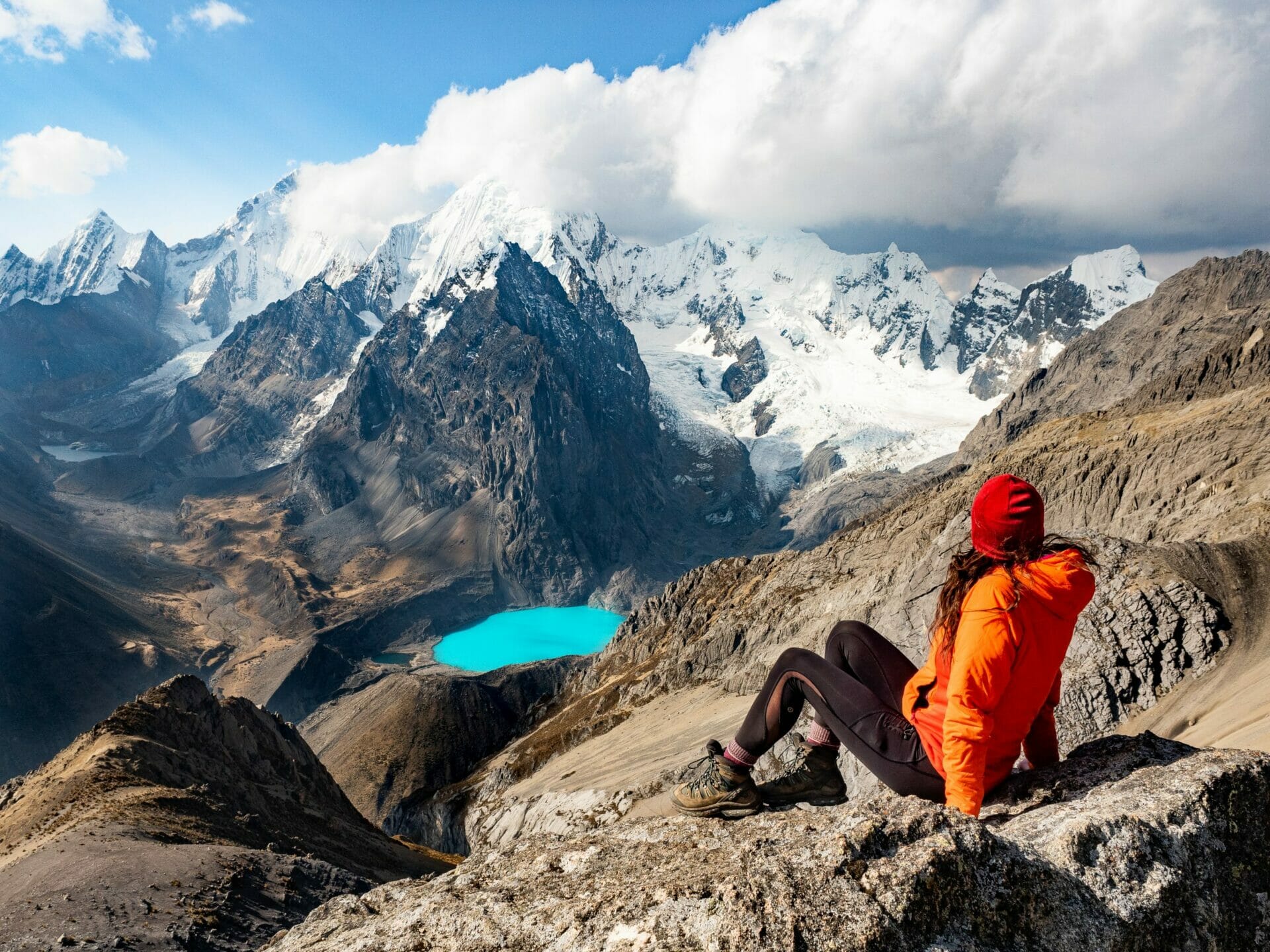
Widely regarded as one of the best alpine treks in the entire world, the Huayhuash Circuit is a remote and impossibly scenic high-altitude route in Peru’s Cordillera Huayhuash (pronounced why-wash). The trail, totalling 135km and crossing 12 mountain passes all above 4,500m, circles some of the highest and most impressive mountains in the Andes, offering surreal vistas of jagged snow-capped peaks, turquoise lakes, and even steamy hot springs.
I hiked the Huayhuash in August 2019 and it remains one of the most challenging but rewarding backcountry experiences I’ve ever had! This is a comprehensive guide to planning your own independent Huayhuash Circuit trek, including acclimatisation, getting to the trailhead, my custom 10-day adventure itinerary, campsites & fees, what to expect on the trail, and more.
🏔️ Check out my Huayhuash Circuit Packing List for essential gear recommendations and my custom 10-day Huayhuash itinerary as a GPS map!
About the Huayhuash Circuit
Peru’s compact Cordillera Huayhuash mountain range, only about 400km north of Lima and yet a world away from the bustling capital, lacks much of the tourist traffic of the nearby Cordillera Blanca (home to the popular Laguna 69 and Santa Cruz treks, among others). Getting off the beaten path is one of the best things about trekking in the Cordillera Huayhuash, a region perhaps best known as the setting of Joe Simpson’s epic survival following a mountaineering accident on Siula Grande (6,344m). “Magical” doesn’t even begin to describe the dramatic peaks or towering glaciers that dominate every angle of this remote trek.
There’s a lot of variability in the time taken to walk the circuit (anywhere from about 1-2 weeks), but your own trek will be a careful balance of how far you can comfortably walk in a day vs how much weight you can comfortably carry on your back. For us, 10 days was the magic number, so that’s what I’m going to describe in this post (you can still use all this info to plan a shorter or longer trip, though!).
Expect to be pushed to your limits, but in the best, most inspiring kind of way— nothing worth doing is easy, and the views are that much sweeter when you earn them with blood, sweat, and the occasional tear.

Hiking independently or joining a guided trek
It’s definitely possible to tackle the Huayhuash Circuit as part of a guided trek. Most of these tours include porters/donkeys to carry your gear and food, leaving you with just a small daypack, and you’ll also have meals prepared for you— which can be a great option if you don’t have the necessary backpacking gear, the confidence to navigate or cope with changing conditions, the stamina to carry a heavy pack, or the time/willingness to plan your own trekking route.
If you do want to join a trekking group, I became friends along the trail with a wonderful local mountaineering guide, Marco Reyes, who owns High Summit Peru in Huaraz— I highly recommend him!
But if you do want to go it alone? The reward of trekking independently is 100% worth the extra effort. I’ll talk more about what to expect on the trail (including navigational demands and the risk of altitude sickness) further down this post, but here’s just a rough idea of what’s required to trek the Huayhuash Circuit independently.
Huayhuash Circuit without a guide: is it for you?
- You can hike 6-10hrs for 10 days in a row, often on very steep or uneven terrain
- You are able to carry 15-25kg in your pack
- You own or can hire all the necessary gear for your trek (see Packing list for the Huayhuash Circuit)
- You have moderate to advanced navigational skills and can read both a map and a GPS
- You know what to do in the case of a medical emergency (especially altitude sickness) and you have a way to call for help (Garmin InReach for SOS)
- You are able to complete at least 2-3 days of acclimatisation, preferably hiking, immediately before the trek (see Acclimatising for your trek below)
*If you’d rather focus on the trek itself and leave the logistics to someone else, joining a guided Huayhuash tour is an excellent option. Many guided expeditions include permits, transportation, and support staff, making for a smoother experience in these remote mountains. Check out guided Huayhuash treks on Explore-Share!

Planning your Huayhuash Circuit adventure
When to hike the Huayhuash Circuit
The Peruvian Andes experience two main seasons:
- Cool, dry winter (also called the “Andean Summer:): May to September
- Slightly warmer, wet summer: October to April
During the dry season (May to September), you can expect consistently clear skies, minimal rainfall, and the best chances for unobstructed mountain views. Temperatures stay fairly mild— daytime highs between 18–22°C and nighttime lows between -10 to 0°C— but the low humidity and stable weather patterns make this the ideal season to trek the Huayhuash Circuit.
During the wet summer (October to April), conditions shift dramatically. Although temperatures are slightly warmer, the trails are often battered by heavy rain, thick clouds, and occasional storms. Visibility can be poor, navigation becomes more challenging, and saturated hillsides or high passes often turn muddy and unstable, making the terrain slippery, eroded, and far more difficult to cross safely. Trekking the Huayhuash during the wet season is not recommended, both for safety and because the spectacular scenery is often hidden by weather!
⚠️ Even in the dry season, mountain weather can be unpredictable. I did this trek at the very end of August and most days were sunny with occasional morning cloud cover that burned off within a few hours— but we woke up one morning to snow flurries and a campsite blanketed in white powder. Always come prepared for rapid weather changes!

Acclimatising for your trek
Acclimatisation is perhaps the most critical step in preparing for the Huayhuash Circuit. This is one of the highest trekking routes in the world and you’ll spend nearly the entire trek above 4,700m (15,400ft), with the highest point reaching 5,090m (16,700ft) at Paso San Antonio. Altitude sickness is a common and serious obstacle at these extreme elevations and, without proper acclimatisation, it will be extremely difficult (if not impossible) to complete the trek safely or enjoyably.
To acclimatise effectively, it’s essential to spend at least several days at altitude before starting your trek. Huaraz (3,050m / 10,000ft) or Cusco (3,400m / 11,150ft) are both excellent bases for pre-trek acclimatisation, offering plenty of day hikes and shorter treks to gradually condition your body. Some great options include:
- Laguna Parón (4,200m / 13,780ft): accessible day hike near Huaraz with incredible mountain views
- Laguna 69 (4,600m / 15,100ft): one of the most popular and effective acclimatisation hikes near Huaraz
- Salkantay Trek (max 4,650m / 15,260ft at Salkantay Pass): a great multi-day option near Cusco if you have extra time
- Ausangate Circuit (up to 5,200m / 17,060ft at passes): a stunning, high-altitude circuit that’s even higher than many Huayhuash passes (but shorter and far easier overall)
Learn more about altitude on the Huayhuash Circuit in the Altitude sickness section below and read this essential post about managing altitude sickness during high-elevation treks and climbs.
😮💨 MY PERSONAL ACCLIMATISATION, FOR REFERENCE
Prior to this trek, I spent two weeks in Cusco (3,400m), where I did Palccoyo (4,900m), the Salkantay Trek (4,650m) and the Ausangate Circuit (5,050m), and then spent 2 days in Huaraz (3,050m), where I also hiked around Laguna Parón (4,500m). All of this acclimatisation prepared me beautifully for the Huayhuash Circuit and ultimately improved the quality of my trip. Even if you don’t have weeks to spend acclimatising, plan a minimum of 2-3 hiking days in Huaraz before your trek!

Essential resources & maps
When you first begin planning your Huayhuash Circuit trek, there are a couple of invaluable resources that will make things infinitely easier. The first, of course, is this blog post! Next, I’d definitely recommend checking out:
My custom GPS route
Especially for those following my 10-day Huayhuash Circuit adventure itinerary, the absolute BEST navigational resource is my custom Huayhuash Circuit GPS map— built from personal experience on the trail, packed with hundreds of waypoints & trail notes, all designed to help you navigate the most adventurous version of this route with ease.
The map is available as a JSON & GPX download, and is compatible with all major GPS mapping devices/watches AND inexpensive GPS apps available on your smartphone, like CalTopo, Gaia GPS, and AllTrails. Let me help you plan & confidently navigate the Huayhuash!
Cordillera Huayhuash map
This is the best map covering the entirety of the Huayhuash Circuit, so I’d recommend purchasing this during the planning stages to help chart an intended route and also carrying it with you on the trail for reference. Unfortunately, this map is no longer available on Amazon, but you can find it on assorted map websites for sale and it’s definitely worth ordering!
Be warned that this map often uses different names for things than the guidebook below, which might be different yet again from your GPS— names in Quechua (the native Andean language) were phonetically translated by Spaniards during the conquest and it’s resulted in 2-3 variations of the same place or occasionally just different names altogether (e.g. Quartelhuain and Cuartelwain and Matacancha are all one place, as is Paso Jurau and Paso Santa Rosa).
Huayhuash guide book
- Peru’s Cordilleras Blanca & Huayhuash: The Hiking & Biking Guide by Neil & Harriet Pike
Although it has many shortcomings, this is the only real guidebook out there that covers the Huayhuash Circuit and therefore it’s still an essential planning resource. Between this blog post and the guidebook, you should have a pretty solid idea of what to expect and how to plan the trek. I’d recommend scanning pages 152-174, printing them on A5 sheets, and packing them in a little plastic folder for reference along the trail.

Getting to & from the trailhead
Getting to Huaraz, Peru
Although it’s still around 150km north of the Cordillera Huayhuash, Huaraz is by far the best base for planning your trek. This bustling mountain town sits at 3,050m (10,000ft) and offers everything you’ll need to prepare: high-altitude acclimatisation hikes, trekking gear rentals, supermarkets, and experienced local guides.
Be sure to download a local eSIM so you can use your phone in Peru!
Flying from Lima to Huaraz
As of 2025, LATAM is once again operating daily morning flights (7:20–8:25am) from Lima to Anta (ATA), about 30 minutes outside of Huaraz. Tickets are typically $50-80, but considering the exorbitant cost of checking bags, the flight ends up being about twice as expensive as the bus. Still, this can be a good option if it lines up better with your itinerary!

Bus from Lima to Huaraz
A more popular (and budget-friendly) option is to take a bus. Cruz del Sur and Civa both run frequent services between Lima and Huaraz, including comfortable 8hr overnight departures— I recommend the 10pm bus from Plaza Norte, which gets you into Huaraz around 6am feeling reasonably well-rested.
👉🏼 Compare departure times, prices & availability for all companies in English on BusBud!
Peru’s long-distance buses are shockingly comfortable: hot drinks, sandwiches, pillows, blankets, personal seat-back screens — you might even forget you’re on a bus! And as of 2025, tickets cost around S/100 (USD $27) for either company, making this the cheapest option to get to Huaraz.
💡 Bus tips:
- Choose a semi-cama (160° recline) or cama (180° lay-flat) seat for maximum comfort
- Buses depart from Plaza Norte (closer to the airport) or Javier Prado (more central if you’re staying in the city)
- You’ll be served a light meal onboard, but it’s a good idea to bring your own snacks and water
- There’s a toilet on board, and most buses also include a pillow, blanket, and personal screen

Getting to the Huayhuash Circuit
Starting in Llamac
The most common starting point for the Huayhuash Circuit is the small town of Llamac, primarily because it’s accessible by public transport from Huaraz. If you’re following the classic budget-friendly route, expect the following:
- Catch a 5am El Rápido or Nazario bus from Huaraz to Chiquián (2hrs)
- Transfer to an 8am Nazario bus from Chiquián to Llamac or Pocpa (2hrs)
- Walk 12km along the road from Llamac to the first campsite at Quartelhuain (approx. 4hrs)
While this option is great for budget travellers, keep in mind that you’ll spend an entire day on buses and foot before even starting the actual circuit — and the 12km road walk is long, dusty, and uninspiring.
Starting in Quartelhuain
To skip the transit slog and save your legs for the mountains, I strongly recommend starting the trek at Quartelhuain (also called Cuartelwain or Matacancha on some maps), which is the first official campsite on the circuit. There’s no public transport here, so it’s not the cheapest option, but it’s well worth the extra cost for the convenience and energy savings.
We arranged a private shuttle through High Summit Peru for $150 USD, which took about 4hrs from Huaraz. The company is run by Marco Reyes, an experienced local mountaineering guide — and if you’re lucky, you might even meet him leading a trekking group on the trail!
This is the best option to maximise departure flexibility and get straight to the good stuff, so my 10-day Huayhuash Circuit itinerary starts and ends in Quartelhuain.

10-day Huayhuash Circuit itinerary
The official Huayhuash Circuit trail offers a wonderful trekking experience, but often there are even better experiences to be had if you get off the standard trail and onto the ruta alpina (the higher, more scenic, and more remote alpine route) to explore lesser-seen gems of the Cordillera Huayhuash.
I’ve provided all the details of my custom 10-day adventure itinerary below, including trail stats, daily highlights, campsites (more info under Camping along the Huayhuash Circuit below), AND my favourite and highly recommended variations to the Huayhuash Circuit that will pack in even more incredible scenery. Use it to inspire and plan your own itinerary or follow it closely, the choice is yours!

Day 1: Quartelhuain to Laguna Mitucocha
The first day of the Huayhuash Circuit starts out with a bang, delivering dramatic alpine scenery and a satisfying climb right out of Quartelhuain to the first high pass of the trek, Cacananpunta (4,690m). From the pass, it’s possible to follow the standard valley route, but the recommended ruta alpina offers a more scenic traverse across open hillsides. Enjoy the rainbow views of Quebrada Caliente before descending!
Trekkers are eventually rewarded with their first jaw-dropping campsite above the turquoise waters of Laguna Mitucocha, with the towering face of Jirishanca as the day’s grand finale. Wild camp on the lakeshore for the most incredible tent views!
- Trail hours: 5hrs
- Distance: 9.1km
- Elevation gain: 685m
- Highest elevation: Cacananpunta 4,690m
- Campsite: Wild camping at Laguna Mitucocha
Included variations
Ruta alpina from Cacananpunta to Laguna Mitucocha: Rather than descend to the lake on the mule route, this is a higher, more scenic option that only adds about 30min of trail time.
Wild camp at Laguna Mitucocha: Instead of back-tracking through the valley to the official campsite in Janca, set up camp right on the shores of Laguna Mitucocha below towering Jirishanca. As you look at the mountain, the left side of the lake provides a slightly better vantage point, but the right side will get sun a full 90min sooner in the morning, so it’s a better option. As of yet, it’s not illegal to wild camp on the Huayhuash— pack in/pack out EVERYTHING when you wild camp and leave NO trace so you don’t ruin it for everyone else!

Day 2: Laguna Mitucocha to Laguna Carhuacocha
The second day of the Huayhuash Circuit dives even deeper, with an off-trail alpine traverse that delivers staggering mountain scenery and a true sense of remoteness. Departing Laguna Mitucocha, the route follows the rugged ruta alpina high above the valley floor, weaving across loose scree, massive andesite slabs, and golden grasslands toward a lofty highpoint below Jirishanca Chico (4,870m).
Navigation is challenging but the views are unparalleled, with hidden valleys, glittering lakes, and serrated peaks filling the horizon. After a demanding descent through open pastures, the day ends with a beautiful campsite on the shores of Laguna Carhuacocha— and an unforgettable glimpse of the mighty Siula Grande and Yerupajá looming above the clouds.
- Trail hours: 6.5hrs
- Distance: 9.1km
- Elevation gain: 715m
- Highest elevation: High point below Jirishanca Chico 4,870m
- Campsite: Laguna Carhuacocha
Included variations
Ruta alpina from Laguna Mitucocha to Laguna Carhuacocha: Rather than climbing over Carhuac through the Hidden Valley, this variation along non-existent trails is steeper, far more challenging, navigationally demanding, and about 3hrs longer than the traditional route— but really spectacular! You’ll rejoin the main trail just before camp.

Day 3: Laguna Carhuacocha to Huayhuash via Siula Pass
The third day of the Huayhuash Circuit is a showstopper, delivering some of the most iconic views of the entire trek. Departing Laguna Carhuacocha, the trail follows the lakeshore before climbing steeply onto a glacier moraine for a glimpse of Laguna Gangrajanca. From there, the classic route ascends through loose, dusty hillsides to the famous Mirador Tres Lagunas, where vibrant lakes reflect towering peaks like Jirishanca, Yerupajá, and Siula Grande.
After soaking up the views, a relentless climb leads to the lofty Siula Pass (4,830m), before a long, leg-burning descent winds through grassy valleys framed by Carnicero and Trapecio. With clear skies and cooperative weather, this unforgettable stretch showcases the very best of the Cordillera Huayhuash.
- Trail hours: 5.5hrs
- Distance: 14.8km
- Elevation gain: 820m
- Highest elevation: Siula Punta 4,830m
- Campsite: Huayhuash
Excluded variations
Mule route via Punta Carnicero: This isn’t a variation I’d recommend, as it skips Siula Pass and the Mirador Tres Lagunas, but my parents took it when they were feeling sick and reported that it was surprisingly beautiful. If you can’t handle the brutally steep ascent up to Siula Pass, at least know that you’ll still enjoy wonderful alpine scenery on this hike, a worthy second-best option.

Day 4: Huayhuash to Viconga Hot Springs
The fourth day of the Huayhuash Circuit brings a welcome reprieve, trading the previous day’s lung-busting climbs for a short, scenic wander through rolling valleys. Departing Huayhuash camp, the trail ascends gently to Portachuelo de Huayhuash (4,770m), a windy pass with incredible views of Trapecio and the distant Cordillera Raura.
After lingering to enjoy the scenery, a mellow descent past shimmering Laguna Viconga leads down into a lush valley, where piping-hot thermal springs offer the perfect reward for tired legs. Between the relaxed pace, beautiful lakes, and a soak under the open sky, today is an absolute dream.
- Trail hours: 4hrs
- Distance: 12.2km
- Elevation gain: 490m
- Highest elevation: Portachuelo de Huayhuash 4,770m
- Campsite: Viconga

Day 5: Viconga to Cuyoc + Paso San Antonio
The fifth day of the Huayhuash Circuit delivers jaw-dropping scenery from start to finish. From Viconga camp, enjoy morning views of Nevado Puscanturpa as the trail climbs steadily alongside towering glaciers, topping out at Punta Cuyoc (5,050m) before skidding down steep scree slopes into a wide, open pampa at Cuyoc camp.
For those with energy to spare, the steep climb to Paso San Antonio (5,080m) reveals a panorama of the Cordillera Huayhuash at its most breathtaking— ice-blue lakes framed by the iconic peaks of Siula Grande, Yerupajá, and Siula Chico. Don’t miss this!
- Trail hours: 5hrs
- Distance: 14.3km
- Elevation gain: 1,270m
- Highest elevation: Paso San Antonio 5,080m
- Campsite: Cuyoc
Included variations
Side-trip to Paso San Antonio: After arriving at Cuyoc camp and dropping your pack, you absolutely can’t miss an ascent of Paso San Antonio. If you’re a fast hiker, you can easily get to the top in 1-1.5hrs, but be warned that it’s insanely steep and the terrain gets really sketchy at the top. For the adventurous (and at your own risk), it’s also possible to scramble up the mountain on the left hand side of the pass for even better views of Siula Grande, Yerupajá, and Laguna Juraucocha below. The descent back to camp takes around 45min.

Day 6: Cuyoc to Laguna Juraucocha
The sixth day of the Huayhuash Circuit is rugged, remote, and wildly scenic, offering a thrilling climb to the highest official pass of the trek. After departing Cuyoc camp, the route ascends steeply toward Paso Santa Rosa (5,060m), revealing sweeping views of Siula Grande, Yerupajá, and a chain of dazzling lakes.
From the windswept pass, a steep descent through loose scree and dirt leads into a dramatic alpine valley. Skipping the official Cutatambo campsite, trekkers can enjoy a spectacular wild camp near Laguna Juraucocha, with glaciers and towering peaks providing an unforgettable backdrop.
- Trail hours: 7.5hrs
- Distance: 13.6km
- Elevation gain: 1,300m
- Highest elevation: Paso Santa Rosa 5,060m
- Campsite: wild camping at Laguna Juraucocha
Included variations
Side-trip to Paso San Antonio: If you didn’t get a chance to climb Paso San Antonio from Cuyoc camp yesterday (or if you’re super keen like me and want to go twice), you can also climb up for sunrise before hitting the trail. As I mentioned before, the ascent should take 1-1.5hrs and the descent is about 45min.
Paso Santa Rosa: Also called Paso Jurau, this high mountain pass offers incredible views of Siula Grande and Laguna Juraucocha. It is actually part of the traditional Huayhuash trail, but my parents and I were the only people who actually took this route from Cuyoc camp, all of the other independent trekkers and the guided group electing to hike out to Huayllapa instead. Let me just say that you’d be missing some of the best scenery of the entire trek! The ascent isn’t nearly as gruelling as San Antonio (although you will have a full pack on, but it’s SO worth the effort).
Wild camp at Juraucocha: Rather than trekking out to the official camp at Cutatambo, set up camp near Juraucocha at the base of the glacier. I’d recommend finding a spot behind the moraine so you don’t absolutely freeze to death at night, but the scenery is still wonderful. From this spot, you’ll be better situated to explore Quebrada Sarapococha tomorrow, one of the absolute best side-trips on the Huayhuash Circuit.

Day 7: Laguna Juraucocha to Rasac via Laguna Santa Rosa
My custom Huayhuash Circuit adventure route now veers completely off the traditional trail, adding an entire day of wild exploration in one of the range’s most dramatic valleys. After departing Laguna Juraucocha, ascend through glacial moraines into Quebrada Sarapococha, a surreal landscape of ice-blue lakes and towering peaks like Siula Grande and Yerupajá.
From Laguna Santa Rosa, a steep, unmarked climb leads to Paso Rosario (5,090m), offering panoramic views over the entire valley. The descent is rugged and demanding, navigating loose scree and shifting boulders before reaching a spectacular wild campsite beneath the snow-capped flanks of Rasac. One of the most unreal places I’ve ever pitched a tent!
- Trail hours: 8hrs
- Distance: 10.3km
- Elevation gain: 1,065m
- Highest elevation: Paso Rosario 5,090m
- Campsite: wild camping at the base of Rasac
Included variations
Quebrada Sarapococha: Ideally, you should spend an entire day exploring this incredible valley, climbing up boulders for better vantage points over Lagunas Santa Rosa and Sarapococha, Siulas Grande and Chico, and Yerupajá before ascending to Paso Rosario or Cerro Gran Vista for the ultimate panorama. This is definitely a lesser-explored area, so it’s unlikely you’ll see any other trekkers, but the reward for all the puzzling navigation and remoteness is truly unreal scenery.
Wild camp at Rasac: After descending Paso Rosario, trek up-valley to the base of Rasac, where it’s possible to wild camp in the shadow of the glacier. This was probably the best tent view we had on the entire trek!

Day 8: Rasac to Huayllapa
Departing from a wild camp beneath Rasac, the trail meanders downhill through wildflowers, waterfalls, and sagebrush, following river crossings and rocky trails toward the tiny village of Huayllapa. After days of rugged wilderness, the colourful town and its warm-hearted residents offer a much-needed reprieve from the deep backcountry. This day is short to give you the opportunity to rest and reset for the final push!
- Trail hours: 4hrs
- Distance: 13.1km
- Elevation gain: 60m
- Highest elevation: Laguna Rasac 4,270m
- Campsite: Omar & Flor’s in Huayllapa
Included variations
Huayllapa: This little town (and I do mean little, it’s hardly more than one street) is only a short detour off the main trail, but I’d recommend stopping through even if just to get a snack from the local shop. The people in town are absolutely beautiful and we actually had a rather amazing encounter with some of the locals, which you can read about in my longer post on day 8. If you do go, make sure to say hola to Omar & Flor from the Brisbine family!

Day 9: Huayllapa to Yaucha Punta
The penultimate day of the Huayhuash Circuit is a gruelling push back into the high mountains, stacking elevation gain upon elevation gain across some of the trek’s most colourful valleys. Departing Huayllapa, the trail climbs steeply past waterfalls and sagebrush before easing into the rolling hills of Huatiaq.
From there, a steady ascent leads over Tapush Punta (4,800m) and onward through broad valleys to the final climb of the day, Yaucha Punta (4,850m). Remote and dramatic, the pass is home to circling condors and sweeping views, offering an unforgettable wild camping experience beneath a wall of jagged peaks.
- Trail hours: 8hrs
- Distance: 16.3km
- Elevation gain: 1,585m
- Highest elevation: Yaucha Punta 4,850m
- Campsite: wild camping at Yaucha Punta
Included variations
Wild camp at Yaucha Punta: I wouldn’t ordinarily recommend camping at a high mountain pass (due to risk of high winds and weather), but we pitched our tent just on the other side of Yaucha Punta out of necessity and found that it made a splendid and scenic campsite. It sets you up for a long final day, but also ensures that you get the magical morning glow on the mountains as you walk along the ridge to Cerro Huacrish tomorrow.

Day 10: Yaucha Punta to Quartelhuain via Rondoy Punta
The final day of the Huayhuash Circuit is a triumphant farewell to the mountains, threading through some of the most spectacular and least-traveled scenery of the entire trek. Departing Yaucha Punta, the trail traverses quiet ridgelines and climbs toward Cerro Huacrish, with condors soaring overhead and golden morning light igniting the glaciers.
Rather than following the standard descent to Llamac, this route tackles two extra high passes—Sambuya Punta (4,730m) and Rondoy Punta (4,750m)—rewarding the effort with sweeping views of icefalls, cobalt lakes, and jagged peaks. With no crowds and unforgettable scenery, it’s a challenging but incredibly fitting way to close the circuit, ending back at Quartelhuain where the journey began.
- Trail hours: 6hrs
- Distance: 21.7km
- Elevation gain: 915m
- Highest elevation: Rondoy Punta 4,750
Included variations
Yacha Punta to Incahuain via Cerro Huacrish: Rather than take the mule route down into Incahuain camp, add just 10min to your trek and follow the ridgeline to Cerro Huacrish for infinitely better views.
Incahuain to Quartelhuain via Puntas Sambuya & Rondoy: Skip the boring traditional exit out to Llamac by tackling 2 high mountain passes above Jahuacocha. The route is probably about 1hr longer than the trek through Pampa Llamac and into town, but the views are incomparable. My parents hiked out to Llamac and reported that the descent was positively brutal and seemingly unending, so it’s not really appealing from any angle. If you need to finish the trek in Llamac, you can walk back along the road (3-3.5hrs), but a better option is organising transport from Quartelhuain (allow 40min to walk here from the trail junction).

Camping on the Huayhuash Circuit
Community fees
A ticketing system was implemented a few years ago on the Huayhuash Circuit— you need to pay a small fee to each of the 9 communities as you pass through their land (irrespective of whether you stay at their campsite). As of 2025, total community fees are S/280 ($75).
When you pay each cobrador (ticket seller), you will receive a small ticket which includes the name of the community, the date, and sometimes also your name. Keep this ticket safe, as you may be asked to present it later to prove that you’ve paid (you will pass through a couple communities twice on the circuit and also through some checkpoints).
Here are the exact fees I paid in August 2019, as well as the location of the cobradores:
- Llamác S/30: paid along the road to Quartelhuain, even if you are in a shuttle (we paid through the window at a road gate)
- Pocpa S/15: paid at Quartelhuain camp
- Queropalca S/40: the cobrador is actually at Janca camp, but will come to Laguna Carhuacocha camp the following day and you can buy a ticket if you missed it previously (if you were camping at Laguna Mitucocha, por ejemplo)
- Quishuarcancha S/30: paid just after crossing the swing bridge out of Laguna Carhuacocha camp as you head towards Siula Pass
- Huayhuash S/30: paid in the morning at Huayhuash camp
- Viconga S/20: paid in the morning at Viconga camp
- Huayllapa S/40: paid along the trail about an hour before Huayllapa
- Cutatambo S/10: this is the only fee we missed, so I can’t 100% confirm the location, but I assume it was at Cutatambo camp
- Pacllón S/20: paid at Gashpapampa camp

Campsites
There are 12 official campsites on the Huayhuash Circuit, each operated by one of the 9 communities who look after the trail. All have flat ground for pitching a tent, a non-potable water source (varying from taps to nearby flowing water), some sort of toilet facility— and pretty much nothing else.
There’s no cost associated with using these campsites, since you’ll pay the community fees regardless of where you sleep, but they are usually in a nice spot and offer a good opportunity to mingle with other trekkers.
⛺️ WILD CAMPING ON THE HUAYHUASH CIRCUIT
When I did the hike in 2019, it was perfectly acceptable to wild camp outside of these designated spots (provided you paid the community fee). I’ve recommended some absolutely epic spots in my 10-day itinerary, but PLEASE pack in/pack out absolutely everything to reduce the environmental impact and ensure that wild camping remains possible for future trekkers!
Here’s a look at designated campsites on the Huayhuash Circuit:
Quartelhuain
Quartelhuain camp is super windy, but there are flushing toilets, so there’s definitely something to celebrate. You’ll buy your first community ticket here even if you aren’t camping.

Janca & Laguna Mitucocha
The official camp near Laguna Mitucocha is actually 20min off the lake shore, so I’d recommend pitching a wild camp closer to Jirishanca. You’ll miss buying your community ticket at camp, but it’s possible to purchase it the following day at Laguna Carhuacocha camp.

Laguna Carhuacocha
This is a beautiful campsite set right on the lake overlooking Yerupajá and Siula Grande. Actually, there are two campsites, but I’d recommend staying at the first one, since the second seemed a bit busier with trekking groups. There’s only a measly squat toilet here, but there’s a tap for water and the scenery more than makes up for the poor facilities.

Huayhuash
Another scenic camp under tall peaks, Huayhuash camp has 2 blocks of nice toilets and taps for water. Again, there are two sites located right next to each other, but the first is usually for independent trekkers (and small groups). You’ll purchase a community ticket in the morning from camp.

Viconga
Perhaps the best camp of all, Viconga has 3 hot spring pools, including one for washing clothes and for bathing off the dirt and grime of the previous 4 days. There is a river running through camp that provides water, flushing toilets, and even a man selling cold beer and Coca Cola. Buy a community ticket in the morning.

Cuyoc
Cuyoc camp has a nearby river for water, plus a little block of flushing toilets. Make sure you make the epic side-trip up to Paso San Antonio!

Cutatambo & Laguna Jahuacocha
Instead of camping at the official site in Cutatambo (a further 30min away), I’d recommend setting up shop on the nearby shores of Laguna Jahuacocha, as this spot sets you up better for exploring Quebrada Sarapococha the following day. Position yourself behind the moraine to avoid icy wind off the glacier at night.

Huayllapa
There’s a little campsite in Huayllapa with good facilities, but I’d recommend staying more local. While travelling through Huayllapa, we got to know an extremely beautiful family who truly went above and beyond to take care of my stepmum during a bad situation. It was their dream to open a hostel, and amazingly they emailed my stepmum a few months after our hike to say that her donation (of just $150USD) allowed them to build the toilets they needed, plus put in a patio out front and paint the exterior of the house. They’ve named one of the rooms in their new hostel “The Brisbine Room”, so now it is MY dream that someone reading this blog post will go hike the Huayhuash Circuit, visit Huayllapa, stay in “The Brisbine room” at Omar and Flor’s, and give them a little more than the S/10 ($3USD) they are charging per bed. I guarantee it will be a highlight of your trek.
Read more about Omar & Flor and our time in Huayllapa in this post: HUAYHUASH CIRCUIT (DAY 8): RASAC TO HUAYLLAPA

Huatiaq
There are 2 Huatiaq campsites, both with similar facilities, including a toilet block and river access for water. The camps are about 5-10min apart, so just choose whichever is less crowded.

Gashpapampa
The is a nice, flat camp just on the other side of Laguna Susucocha. There are unappealing squat toilets and also river access for water.

Incahuain
Incahuain is an absolutely gorgeous campsite on the shores of Laguna Jahuacocha. There were quite a few people here, but enough room that it didn’t seem at all crowded, plus abundant water access and ample opportunities for a chilly swim (!!).


What to expect on the trail
Navigation on the Huayhuash Circuit
If you haven’t figured it out yet, the Huayhuash Circuit is navigationally demanding— especially if you plan to follow any of the high-alpine detours or lesser-travelled side trips I’ve recommended. This is not like hiking in the Alps, where well-marked junctions, graded trails, and other hikers make it easy to stay on course! On Huayhuash, I counted just 2 signs on the entire circuit, and spent full days contouring across hillsides in what we hoped was the right direction, often without seeing another soul.
Even with a map, guidebook, GPS, and an experienced mountaineering crew, there were days we spent 90% of our energy just trying to stay on route. You absolutely need to be a confident navigator to attempt this trek independently— and you should always have multiple tools at your disposal.
- The Cordillera Huayhuash guidebook (pages 152–174)
- A topographic map of the Huayhuash
- A GPS app or device with a downloaded route file
🗺️ I’ve created a custom GPS map of the Huayhuash Circuit, designed specifically for the 10-day adventure itinerary featured in this guide. It’s built from personal experience on the trail, packed with hundreds of waypoints, detailed navigation notes, and alternate routes to help you confidently tackle the most adventurous version of this trek!
The map is available as a JSON & GPX download, fully compatible with all major GPS apps and devices, including CalTopo, Gaia GPS, AllTrails, and Garmin. Whether you’re planning your route or navigating on-trail, this map will save you hours of guesswork and keep you on track for an epic adventure.

Terrain & trail conditions
One of the most challenging (and rewarding) aspects of the Huayhuash Circuit is the sheer wildness of the terrain. This is not a manicured trail system; much of the time, there’s no clear trail at all.
Expect to spend long stretches contouring across terraced hillsides, picking your way across loose scree slopes and moraine rubble, squelching through alpine pampas, and (if you’re lucky) following faint sheep trails that disappear just as quickly as they appear.
Beyond the navigational challenges, the technical nature of the terrain demands steady footwork, strong off-trail competence, durable hiking boots with high ankle support, and a good pair of trekking poles to maintain balance over uneven ground.
🥾 See my full gear list here: Complete solo Huayhuash Circuit packing list: what to pack for 10 days without a guide

Especially when you get off the main trail and onto the ruta alpina, it’s extremely likely that you’ll be doing some bush-bashing, trail-blazing up the side of a rough hill, or even scrambling over large rocks.
This off-trail, choose-your-own-adventure style is all part of the magic of Huayhuash— but it means you need to be comfortable navigating rugged, remote landscapes without clear paths. The route is best suited to experienced backpackers looking for a challenge!

Altitude sickness on the Huayhuash Circuit
For a high-altitude trek like the Huayhuash Circuit, where you never really step below 4,000m and you frequently ascend above 5,000m, you’ll notice the lack of effective oxygen in the air right away. For most hikers, this means shortness of breath, loss of appetite, frequent urination, and trouble sleeping.
Beyond these normal responses to elevation, some people also experience altitude sickness, and the risk on this trek is pretty high. “Altitude sickness” refers to a spectrum of conditions, including:
- Acute Mountain Sickness (AMS), which can range from mild to moderate
- High-Altitude Cerebral Oedema (HACE) and High-Altitude Pulmonary Oedema (HAPE), both of which can be life-threatening
It’s incredibly important to understand the risks, take appropriate preventative measures, and know what to do if you do become unwell on the trail. I wrote a super detailed post on high-altitude trekking that I would recommend reading— it will give you heaps of information on recognising and treating altitude sickness, plus what you can do to prevent it.
In brief, the most important things you can do on this trek to minimise the risk of serious altitude-related health complications are to:
- Acclimatise: I mentioned this previously, but it bears repeating that acclimatising properly before beginning your trek is probably the single best way to prevent altitude sickness on the Huayhuash Circuit. This should include at least a few days in Cusco or Huaraz, plus some high-altitude day-hikes.
- Ascend slowly: The itinerary described in this post splits up the elevation gains into reasonable daily ascents, particularly in the early stages, to help pace the cardiovascular demands of altitude.
- Camp low: The placement of campsites along the Huayhuash Circuit makes it easy to follow the “climb high, sleep low” principle, which can also assist in acclimatising on the trail.
- Understand altitude sickness: Again, it’s so important to recognise the symptoms of altitude sickness and respond quickly. Sometimes it’s as simple as descending to a lower elevation until you feel better, but other situations will also require medication or evacuation. Severe altitude sickness can be fatal within 24hrs, so it is no joke.
- Pack altitude sickness medication: No one ever plans to develop life-threatening altitude sickness, but it’s vital to be prepared, just in case. See a doctor and get a prescription for Acetazolamide, Dexamethasone, and Nifedipine before your trip. I found that my doctor knew very little about altitude sickness medication, so I did a lot of research in medical journals to find the appropriate dosage. It might be a good idea to read this post prior to seeing a doctor so you can discuss the information with them.

Water
All official campsites along the trail have some sort of water access, be it a river, lake, or even just a running tap, but none of this water is clean or safe to drink without filtering first.
Boiling water before cooking will obviously make it potable, but I’d recommend packing a simple filtration system to quickly prepare water for safe drinking. I’ve used this filter for many years!
Food & other supplies
Aside from the cold beer and CocaCola sold at Viconga camp, the only place on the Huayhuash Circuit to replenish food and supplies is in the little town of Huayllapa (day 6-8 of most itineraries). In 2019, they weren’t selling fuel for camping stoves, but there were snacks and drinks available from a little shop, as well as hot meals made to order.
If you’re tight on weight, you could pack just enough food to get you to Huayllapa and do a complete restock there, but know that there definitely isn’t any freeze-dried mountain food, so you’ll be carrying heavy, bulky items. It’s probably still lighter than carrying 10 days of food from the outset, but we decided we’d rather play it safe and pack things we knew we could fill up on rather than rely on snacks.

Safety
Many years ago, a young hiker was robbed at gunpoint and killed on the Huayhuash Circuit, leading to the conclusion that this area just wasn’t safe for independent trekkers. In the decades since, the local community has done a lot to restore safety to this area, and there’ve been absolutely no incidents in recent years. This is thanks in part to the 9 communities along the trek, who have assumed responsibility for looking after the trail and those on it.
It’s impossible to say that nothing bad will ever happen on this trail again, but the Huayhuash Circuit felt completely safe during my trip, regardless of whether we were staying at designated camps with other trekkers or camping entirely on our own.
Far greater than the threat of robbers is Pachamama, whose constantly-changing weather and unpredictable trail conditions can make for a challenging trip. Under no circumstances should you embark on this trek without a well-stocked first aid kit, a good knowledge of mountain survival, and a Garmin InReach for SOS.

Packing list for the Huayhuash Circuit
Packing for the Huayhuash Circuit is all about balancing weight, warmth, and self-sufficiency. With no real resupply points along the trail and no guide to carry your gear, you’ll need to be strategic about every item in your pack— especially when it comes to weather protection, backcountry food, and sub-zero sleeping gear.
Check out my full gear list: Complete solo Huayhuash Circuit packing list: what to pack for 10 days without a guide

Read more about the Huayhuash Circuit
SOLO HUAYHUASH CIRCUIT PACKING LIST: WHAT TO PACK FOR 10 DAYS WITHOUT A GUIDE
HUAYHUASH CIRCUIT (DAY 1): QUARTELHUAIN TO LAGUNA MITUCOCHA
HUAYHUASH CIRCUIT (DAY 2): LAGUNA MITUCOCHA TO LAGUNA CARHUACOCHA
HUAYHUASH CIRCUIT (DAY 3): LAGUNA CARHUACOCHA TO HUAYHUASH
HUAYHUASH CIRCUIT (DAY 4): HUAYHUASH TO VICONGA
HUAYHUASH CIRCUIT (DAY 5): VICONGA TO CUYOC & PASO SAN ANTONIO
HUAYHUASH CIRCUIT (DAY 6): CUYOC & PASO SAN ANTONIO TO LAGUNA JURAUCOCHA
HUAYHUASH CIRCUIT (DAY 7): LAGUNA JURAUCOCHA TO RASAC VIA LAGUNA SANTA ROSA & PASO ROSARIO
HUAYHUASH CIRCUIT (DAY 8): RASAC TO HUAYLLAPA
HUAYHUASH CIRCUIT (DAY 9): HUAYLLAPA TO YAUCHA PUNTA
HUAYHUASH CIRCUIT (DAY 10): YAUCHA PUNTA TO QUARTELHUAIN VIA RONDOY PUNTA
The Comments
Rachel
Do you think it would be reasonable to do this solo? My brother said he’d do it with me but now he says he won’t have time for at least the next three years and honestly I’m not holding out hope he’d be available after that. I’d like to do it self supported for the freedom to adjust my itinerary on the fly depending on my condition, the weather, recommendations from other hikers I run into, etc plus the less trafficked alpine route definitely appeals to me. I’m just a little hesitant from a safety standpoint like if I broke a leg or got bad altitude sickness.
brooke beyond
RachelHi Rachel, I’m a long-time solo backpacker and I absolutely think you’d have a great time on this route solo ONLY IF
– you are strong enough to carry all the camping gear and cookware yourself (no one to divide weight with) AND
– you are a strong navigator (the route is very hard to follow) AND
– you have a PLB, like the Garmin inReach <<< having emergency communication is going to be vital, since much of this route is incredibly remote
In camps, you're likely to be with other hikers and guided groups (as Huayhuash has gotten more popular in recent years), but on some of the high passes, you're right to worry about what would happen if you got injured. I would absolutely not consider going solo without an SOS device.
All that being said, this is still the best hike I've ever done and I'm confident you'd have an incredible time with all those safety measures in place!
xx bb
Joshua
Hi Brooke!
Thank you so much for taking the time to put together all these invaluable resources!! I am hoping to do this hike in July 2026. My question is about your photos–Which camera do you use? I absolutely love the colors and quality of your photos!
Thank you!
brooke beyond
JoshuaAh thank you, Joshua! These photos were all taken with my Olympus OMD EM5 M2 with a 12-40mm lens. It’s an awesome, lightweight mirrorless camera with great quality, I used it for nearly a decade!
Enjoy your hike!
xx bb
Chloe
Hi Brooke, thanks so much for this amazing blog. I’m doing this hike with two girl friends at the end of the week, we’re experienced hikers but do you think it would be safe for three women going independently? I can’t find a path going over Paso Jurau on my GPS app, I have the guidebook, is it easy enough to find/ is there a map app you recommend that has it on? Thanks so much!
brooke beyond
ChloeHi Chloe, hope you see this message before you leave for your hike!
Yes, it’s definitely safe to do as three women, but the navigation is very confusing, so I highly recommend downloading the custom route map I built for this trek and using it offline with CalTopo so you don’t get lost in the lost or into dangerous terrain.
https://shop.brookebeyond.com/b/huayhuash
Hope that helps 🙂
xx bb
Travis
Thanks for the great post Brooke – really helpful as usual!
Could I ask two quick questions please:
1. I’ve read elsewhere to get a 4-season tent for this trek, but I’d really rather not and was interested to see you recommend a 3-season one. Was the wind or cold not really bad enough to justify a 4 season?
2. Is it very wet under foot during the Andean Summer? Just wondering whether I can wear my non-Goretex trekking shoes
Thanks in advance!
brooke beyond
TravisHey Travis, so glad to hear you found this post helpful!
I did the trek with a 3-season tent and yes it was cold, but it held up reasonably well– it’s not typically too windy in the Huayhuash and that’s when the upgrade from 3 to 4-season makes the most sense. I don’t know if I’d recommend carrying the extra weight on this trail, it’s already A LOT! At most, look at a more robust 3-season tent (not an UL one) and I think you’ll be reasonably happy with that middle ground.
As for the need for waterproof shoes, you can get away without Goretex as long as you’re truly there in the middle of the season (May will still have some snow melt) AND you’re prepared to get a little wet if it happens to snow one day (not super likely, but we did get flurries one day). Personally, I’d be comfortable wearing a non-Goretex boot in June-Aug, if that helps!
Happy trails 🙂
xx bb
Michael
Simply a beautiful and amazing post, and a great summary with all kinds of amazing info with side trips and the like. I did the John Muir Trail last year, which didn’t require route finding, but I averaged 18 miles a day with lots of passes and elevation, though not as high altitude.
I don’t want to be done hiking early in the day. I am not looking for a lot of downtime. The guided treks look like they are often done by early afternoon. I don’t want to underestimate the elevation, but 10 miles a day doesn’t sound like a lot. I am used to walking until it starts getting dark.
Do you think I should plan on more days because of the altitude challenge?
I am super excited to read the rest of your posts to inspire adventure. Thank you!!
-Michael
brooke brisbine
MichaelHi Michael,
This is a tough one! With experience doing 18mi a day with a lot of elevation and passes, you could potentially move faster and farther than what I’ve laid out in this guide. BUT the elevation is not insignificant, nor is the difficulty of terrain or navigation– these are the main things that will slow you down on the Huayhuash, which is a true backcountry adventure with off-trail demands and a LOT of altitude.
What I can say pretty definitively is that you should expect to move a lot slower here than you have at lower elevations on an established trail. Whether that’s just a few fewer miles in a day (15mi vs 18mi) or more in line with the itinerary I’ve recommended here is hard to predict, but absolutely hiking in the Cordillera Huayhuash is not like hiking JMT.
Here’s the great thing about the Huayhuash, though: there are established camps, but you don’t really have to stay in them and you certainly do not need to book in advance. So my best piece of advice is to acclimatise beforehand (!!!) and then allow yourself 10 days for the full itinerary, but know you might be able to finish in 7 or so, depending on your speed. No need to have it all mapped out in advance, you can play it day by day depending on how you’re coping with the altitude and terrain.
Hope that helps!
xx bb
Morgan
Do you have a GPX file of your route? This post is so helpful
brooke brisbine
MorganHi Morgan,
I’m actually in the process of publishing GPX/JSON files for all the major treks on my site, and hopefully these will be available for sale super soon! I’m also heading out to re-hike the Huayhuash again this May, so expect additional updates to this post and a 2025 map file.
If anyone wants access to the GPX ahead of my webstore going live, please reach out via email and I can send it to you 🙂
Happy trails,
xx bb
Yarden
Thanks for the guide! It was very useful for us when planning our hike. Sharing a few tips we learned and might be useful:
1. For getting to the Huayhuash we found a good balance of saving money and time by taking the bus to Chiquian and the a taxi to Quartelhuain from there. The taxi then cost 200 soles. We were lucky enough to have it shared between 4 people, making it very reasonable.
2. Viconga now has hot meals for lunch (we had rice and lentils) and wifi.
3. Perhaps not a *good* tip, but if needed (or just tired) one can get off the trail at Huallapa. There’s a combi leaving to Cajatambo at 6:30am, and from there one can take a bus to the coast and then to Lima/Huaraz. Overall it took us 14 hours to get back to Huaraz like that.
brooke brisbine
YardenThank you so much for sharing some alternate transport options and updated info for the trail!
Happy trails 🙂
xx bb
Roberta dos Santos
Hi, Brooke! It was the most complet post I saw about de Huayhuash Trek and I loved it.
I’m going to do this Trekking all by my self alone (woman solo backpacking) at 23/August and I would like to know if you could share that image of the map your dad made of the Huayhuash Circuit that appears in your report (because I don’t have that book you indicated available for my country – Brazil).
Could you? It would help a lot because it’s my first backpacking to a cold place (I’m from Amazônia, a really hot region) and I’m little scary lol.
brooke brisbine
Roberta dos SantosHey Roberta! I am SO sorry for the slow reply, I think I missed sending you that map before you set off for your trip!
I hope you had a fantastic time and managed to find a copy of the map I recommended when you arrived in Peru?
Happy trails
xx bb
Marie
Hi Brooke,
Thank you for the detailed (& inspiring!!!) description of the trek! I’m planning on going solo end of March this year and was wondering whether you could share your GPX route for the trail – I’ve found quite a few alternatives online, but I like your route description the best and would be great if I could stick with it 🙂
Would you recommend bringing a satellite communication device (like Garmin inReach or the like) for going solo to be able to communicate with friends & family or are there a few spots throughout the hike with mobile connection? I’ve done quite a few solo treks in remote locations, but none this challenging (high altitude) so I imagine my family would feel a bit calmer if the heard from me every now and then. Also, I know March is considered end of raining season but you’ve repeatedly mentioned how cold you were – when did you go & what kind of sleeping bag did you bring (mine’s at 5 to -10 degrees, considering whether I’d need a better one).
Sorry to bother with all these questions and thank you again for this amazing blog!
Marie
brooke brisbine
MarieHi Marie,
I am in the process of putting together detailed GPX tracks for all of the backpacking routes I’ve written up on my blog, let me see if I can get that Huayhuash one out sooner rather than later so you’re able to use it to plan your trip!
I ABSOLUTELY recommend bringing and In-Reach– honestly, you should not hike alone without one in mountains like these. My route in particular takes you off the beaten path and I went days without seeing other humans, mobile reception was non-existent, and an accident would have been fatal without an SOS device, so please take one with you! Added bonus of being able to get weather reports and send check-ins to family 🙂
I went in August with a -8C bag– the temp doesn’t fluctuate much throughout the year, so expect it to be very cold whenever you go. It is honestly the coldest trip I have EVER done, still to this day. I ate dinner almost every night in the tent because I simply couldn’t sit outside. If you also get cold, consider packing a liner that will add some heat to your existing bag.
Hope that helps & don’t hesitate to ask future questions, always happy to help, especially fellow solo female adventurers 🙂
xx bb
Andrew
Hi Brooke,
i. a stay at Siula Grande base camp instead of Laguna Juraucocha which involves a chilly wade across a stream but is pretty magical – this could be a variation;
ii. I trotted down all the downhill sections on the last day, was well acclimatized and used to run for GB and just managed to do it in 6 hours, so, I think it would take most people 9 hours, not the 6 which you recorded. There is a risk of people missing transport links out if they try to do it in your speedy 6 hours.
iii. Turismo Nazario on +51 990298650 will do transport to and from any trailhead to/from Huaraz or Chiquian
brooke brisbine
AndrewThanks for the additional information, Andrew! And good note about the times posted here– you followed my alternate route exactly?? I know for sure I wasn’t running on any sections of this trail, so I wonder if we did a slight variation and that’s where the time discrepancy comes from? Nonetheless, great to note for those who are scheduling a hike out.
xx bb
Aaron Jobson
Thanks for the great information Brooke. Just completed a 6 day hike in the Huayhuash and referenced your post a lot in the planning. We ended up getting a pretty good storm even in June and returned to Huaraz from Huayllapa. Fortunately we followed your recommendation and booked transportation with Marco and High Summit Peru. He saved us Snead all around amazing as you said. He says to say hi!
brooke brisbine
Aaron JobsonHey Aaron, definitely a bummer about the storm, but I am SO happy to hear Marco was able to help you guys out, he’s truly the best guide in the area!
xx bb
Ollie
Hi all. Just to comment about doing it out of season. I did it in February, the worst month for weather. And it was doable! Definitely lost out on views sometimes and it rained most afternoons – making it cold! But we saw no other trekkers and still had fun! Just a heads up for anyone who can’t choose when they are in Peru!
brooke
OllieThanks so much for sharing, Ollie! It’s great to hear that the Huayhuash still holds up out of season– I spent December trekking in Peru several years previously and, despite the rain, I still wouldn’t trade the trip for anything.
Marcin
brookeVery valuable information. I do it in July. Will I get camping gas for a tourist stove in Huaraz? Is there freeze-dried food in Huaraz? Regards
brooke brisbine
MarcinHi Marcin, you can definitely find fuel, food, and all variety of backpacking/camping gear for sale in Huaraz!
Happy trails,
xx bb
Luca
OllieI’ve been looking for this sort of comment for days! I think I’m gonna do it next February/March, it’s when I wanna get away from London and when I’m the least busy with work, so my only option really…But I wasn’t sure it was doable
So besides of the weather, is support available in terms of camping sites/ transportation/ any logistical help? I’m thinking to do it solo and without guide, but just in case…
Thanks!
Luca
Jill
This blog is so amazing and helpful! Just want to update that the community fees have increased a lot since 2019. I would bring S/300 per person just for the community fees. You can ask a travel agency in Huaraz for updates on how much the total trek will cost you. And don’t forget to be respectful and leave no trace so hikers can continue independently enjoying the route 🙂
brooke
JillThanks so much for the update, Jill! So glad to hear you enjoyed the trek.
Did you happen to take notes on the new amounts– I’d love to update this post with current pricing!
Happy trails 🙂
Jack Pendleton
Planning on doing this independently this July… Can I rely on AllTrails to be my map and GPS? That’s what I use for all my treks I’ve done before and I’ve mapped out a good route for Huayhuash, but can GPS signal be relied upon there? Many thanks for any advice.
brooke brisbine
Jack PendletonHi Jack,
GPS signal is reliable– I used Gaia a few times on this hike (although I like it far less than Alltrails).
You might find that your map doesn’t perfectly line up with all the trails you’ll see on the Huayhuash, though, as a lot of these paths are worn by animals and infrequently trafficked by people, in particular along the Ruta Alpina (which I’d HIGHLY recommend hiking wherever possible, as it’s far more scenic). Bring the paper map as well and prepare to do some route-finding in spots, but Alltrails should certainly help.
Happy trails!
-Brooke
François Lechasseur
Jack PendletonHi Jack,
Did you do your trip? I’m thinking to do that trip too and I would like to know if we can use All Trail. Did you hire a guide? How many day did you take to complete the 130 Km?
I’m from Canada
Charles Van Cauwenberghe
Hi Brooke,
Thanks for your additional good advice!
After getting the Alpenvereinskarte we really can’t wait for our trip to start.
About Paso San Antonio being dangerous, is that why you ascended it as a side trip and actually crossed Santa Rosa on the next day? Also; passing Rosario pass seems like quite the adventure (the route is not even mentioned on the map :p). And a final (for now :D) question: Would you recommend, as the final day of the trek, to go towards Cuartelhain or Llamac?
brooke brisbine
Charles Van CauwenbergheHi Charles, no worries at all, happy to help 🙂
That’s exactly right, Paso Santa Rosa (also called Paso Jurau) is not as steep as Paso San Antonio and is widely considered to be the better option. After trekking up to San Antonio as a side trip and looking down the brutal scree field on the other side, I can’t imagine descending. I suppose some people do, not knowing that Santa Rosa is a better alternative, but I would not recommend it, nor did the mountaineering guide I met on the trail. I was actually the only person of the guided group and independent trekkers who even went up San Antonio and the following day my family were the only people to cross Santa Rosa, all the other hikers taking an easier route out to Huayllapa.
Yes, Paso Rosario was a definite adventure! Even if you don’t go over Rosario, I highly recommend exploring the Quebrada Sarapococha–it was one of the most spectacular spots on the entire trail and we had it entirely to ourselves. Camping beneath Rasac on the other side of the pass was also a real highlight for me!
As for the hike out, I’d make a strong case for Quartelhuain. Now, there is no public bus from here, so if that’s how you’re hoping to get back to Huaraz, it might not be the best option, BUT if you can organise private transport, the hike out to Quartelhuain is a million times nicer. I did the high route over Rondoy to finish in Quartelhuain while my parents opted for the easier route straight down to Llamac, and they reported that the descent was awful and unrelenting. The scenery over Rondoy was amazing, I didn’t see a single other hiker the entire day, and I got to complete the circuit fully back to my starting point– so I’d recommend Quartelhuain 🙂
Happy trails!
-Brooke
Charles VC
Hi Brooke,
Thank you for what is probably the most elaborate and exciting guide i’ve read so far on solo-trekking the Huayhuash circuit. Me and a friend of mine are relatively experienced in high altitude solo-trekking (mainly in Central Asia, so we are used to spend 50% of our time actually searching for the trail). I do have one question (at the moment :p); Is the ‘Ruta Alpina’ variation indicated on the Alpensvereinskarte or do we need to do additional research on this (and other) variations from the classic route?
Thanks again for your great guide!
brooke brisbine
Charles VCHi Charles, thanks so much for the message!
“Elaborate and exciting” is everything I aspire to be, so obviously this is one of the best compliments I’ve received on the blog!
The Ruta Alpina trails are shown on the Alpensvereinskarte and sometimes described in the guidebook, as well as shown on most GPS maps of the Huayhuash. It’s great that you have off-piste experience, though, because it is HARD to find the route even with a map, book, and GPS app (what I like to call “all the gear and no idea”). It’s the combination of there being (a) a lot of trails to begin with, (b) zero signs or cairns, (c) local foot traffic from farmers and mules that disguises the correct path, (d) erosion, (e) etc etc etc.
Given how little there is out there on the Huayhuash Circuit, it will be challenging to do too much advance research on the route (beyond what’s in this post or in the guidebook). My best advice would be to lay out a loose idea of the trek, even looking at the map to find interesting alternate routes, but then MAKE SURE you speak to a local mountaineering guide to confirm that the route is feasible. There are some passes that are technically passable– Paso San Antonio, por ejemplo— but any local mountaineer would tell you DO NOT descend because it’s wildly unsafe and neighbouring Paso Santa Rosa is better.
There’s a great B&B in Huaraz, Casa de Maruja– the owner is a mountaineering guide and he will happily look at your trekking plan with you to offer advice before you set out. We also met a mountaineering guide along the trail and asked some advice as our plans changed– he confirmed it was safe for us to go up and over Paso Rosario. You seem to know what you’re doing so I probably don’t need to say this, but yeah, it’s just a good idea to speak to someone who’s done what you’re trying to do, since there are some seriously challenging spots in these mountains.
Happy trails to you, and let me know if you have any other questions!
-Brooke