• start here
  • about
  • group trips
  • brooke beyond

  • hiking guides
  • outdoor gear
    • hiking boots
    • hiking backpacks
    • cold-weather layers
    • backpacking tent
    • outdoor sleep system
    • backcountry food
    • day-hike packing list
    • hut-to-hut packing list
    • via ferrata packing list
    • backpacking packing list
    • mountaineering packing list

brooke beyond

Guanajuato Mexico vanlife
Guanajuato / Jalisco / Latin America / Mexico

Vanlife diaries #49: Tlaquepaque & Guadalajara, Jalisco to Guanajuato & San Miguel de Allende, Mexico

16 February 2022

Last Updated on 4 January 2024

We wrapped up several wonderful weeks in Jalisco by visiting the state capital and Mexico’s second largest city, Guadalajara, which was far more delightful than we’d imagined. The end of the week brought even more excitement as we headed inland to Guanajuato, getting farther off the tourist track and eventually exploring three-time winner of “Best City in the World”, San Miguel de Allende. 

What we’ve been up to this week

Tlaquepaque, Jalisco

After a wonderful few days spent exploring Lake Chapala, Mexico’s largest freshwater lake, and the charming towns that surround it, we backtracked north to Guadalajara to finish our time in Jalisco with a bang. 

So far, we’ve spent more time in Jalisco than any other state of mainland Mexico, owing to its incredible diversity of cultural experiences, beautiful landscapes, and magic towns. I wasn’t expecting much from Guadalajara and had even suggested omitting it from the itinerary in the interest of time (you’d be amazed how quickly 6 months in Mexico flies by), but it ended up being another fantastic destination— particularly Tlaquepaque.

Tlaquepaque Guadalajara Jalisco Mexico vanlife
Tlaquepaque is yet another Pueblo Mágico in Jalisco

Once its own city but since incorporated into the urban sprawl of Guadalajara, Tlaquepaque has retained the relaxed atmosphere and cultural charm of a much smaller town, hence its designation as a Pueblo Mágico. 

If you’ve been reading my weekly updates for a while, you’ll recall that I’ve become intent on seeking out these “magic towns”, an official honour bestowed upon historically, culturally, or naturally significant pueblos throughout Mexico.

Without exception (and by definition), these are always shining examples of local heritage with heaps of worthwhile attractions, well-maintained town centres, and a tendency towards increased safety— in the case of Tlaquepaque, the police directed us to park on a well-lit street where they would be patrolling all night.

Tlaquepaque Guadalajara Jalisco Mexico vanlife

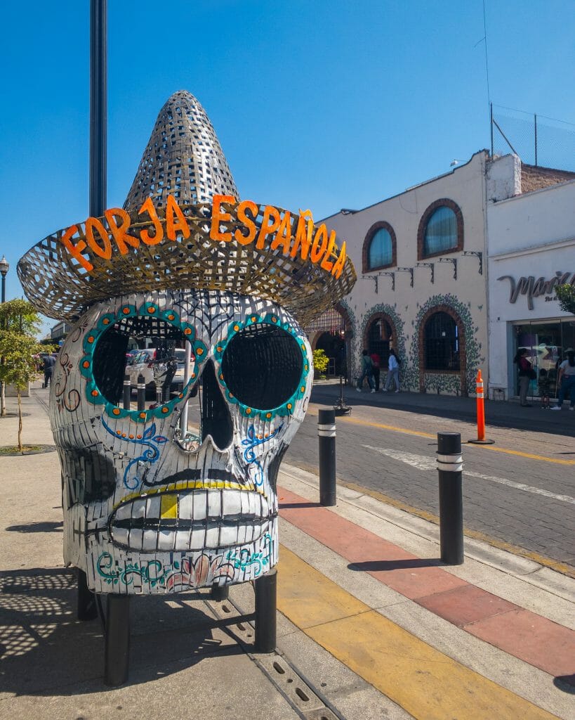
We enormously enjoyed our time in Tlaquepaque, whose city blocks are dominated by street sculptures, colourful art, and manicured gardens, and even took the opportunity to sample a number of local delicacies that had long been on my list. 

The first was tejuino, a traditional corn-based beverage topped with lime sorbet that is native to Jalisco and rarely found outside the state. It is only about 2% alcohol thanks to the short fermentation process and it’s sold from countless vendors around the plaza, handed off as a sweet treat to locals and visitors in an enormous plastic cup.

Tlaquepaque Guadalajara Jalisco Mexico vanlife
A cold cup of tejuino topped with lime sorbet

We also sampled the truly inventive and very delightful Mexican treat of tostilotes, a variation on the equally popular tostilocos (also called dorilocos) sold throughout the country.

Both snacks involve cutting open a small bag of Tostitos or Doritos (hence the name) and stuffing it full of an almost nonsensical amount of toppings and sauces, which you then eat directly out of the bag wth a spoon. In the case of tostilotes, those contents are grilled corn, cotija cheese, butter, cream, chile, lime, and all the hot sauce your little heart might desire. 

Guanajuato tostilotes
Local vendor dishing up an enormous bag of tostilocos
Tostilotes elotes Mexican street food
Tostilotes in Mexico

When I first saw tostilocos in Baja, I assumed this was a street food specifically catering to gringos who are interested in developing a heart condition or at least children with no concept of cholesterol, but I’ve since seen Mexicans of every single age eating tostilocos and tostilotes as if they are a food group. 

And if it’s good enough for the locals, then it is absolutely good enough for me— and really, it was excellent, I will absolutely be eating this in the future. It combines all the cheesy appeal of elotes with the crunch of Doritos and is among Mexico’s greatest culinary contributions to humankind.

Tlaquepaque Guadalajara Jalisco Mexico vanlife
Loving the bright colours and abundant art of Tlaquepaque

Although neither were necessarily new foods, we also loved the local pulque spot, charmingly named Tlaquepulque, which serves 2 different styles of this ancient fermented agave beverage (one of my favourite things in Mexico, described at length in this post) and a variety of curados (pulque blended with fruit). 

But the highlight of our time in this little Pueblo Mágico came purely by coincidence. As we were walking through a market, a Mexican man called out to us in English and offered to answer any questions we might have on the area or where to go. Born in Cuidad Juárez in Chihuahua, Mexico but currently residing in New Mexico, Gilbert and his wife were spending 6 months renting a room in Tlaquepaque and enjoying the Mexican winter.

After much conversation, Gilbert invited us to listen to mariachi, which was proudly invented in Jalisco— every day at 3.30pm, a full mariachi band performs at El Parián de Tlaquepaque and you can sip drinks or nibble snacks at any of the restaurants that surround the enclosed plaza (which claims to be “the world’s largest bar”) to enjoy the music.

Incredibly generously, Gilbert ordered us an enormous cantarito (a traditional Jalisco cocktail made from tequila, grapefruit soda, and a whole heap of fresh-squeezed citrus) and even a plate of chips to share while we waited for the mariachi, but soon he learned from a passing musician that the performances had been reduced to weekends only since COVID. Determined to show us a good time, Gilbert paid the entire mariachi band to perform 2 songs directly at our table.

Tlaquepaque Guadalajara Jalisco Mexico vanlife
Mariachi & cantaritos with our new friend in Tlaquepaque

Not only was the drink wonderful, the setting beautiful, and the music truly amazing— we were once again astounded by the generosity of Mexican people. It seems every week that I have some new story of being taken on an impromptu private tour QUERETERAO LINK or waved away from a transaction without paying or even being handed a gift, and ultimately it is a constant reminder of how special this country and its people are.

While the media may portray a different perspective and the incoherent rambling of lunatics (Trump ugh) suggests that Mexico is full of unscrupulous criminals who exist only to take advantage of every situation, the reality is that this is one of the most inclusive, welcoming, kind, overwhelmingly generous countries I’ve ever visited. 

People are genuinely excited that we’re here and they want to share their country and their culture with us! It’s an incredible feeling and something very rare indeed— I certainly don’t have stories like this from a majority of the other 45 countries I’ve travelled through. Mexican people continue to make our experience here even more special and I’m determined to let everyone know about it. 

Tlaquepaque Guadalajara Jalisco Mexico vanlife
Guadalajara Jalisco Mexico vanlife
Centro Historico

Guadalajara, Jalisco

Incredibly impressed by Tlaquepaque, we headed into the Centro Histórico on Wednesday to explore Mexico’s second-largest city.

After parking our van in a secure lot (a modest $12USD to park for 2 full nights, where of course we also slept in our van), we spent a majority of our time walking enormous distances across Guadalajara to take in all the impressive sights.

Guadalajara Jalisco Mexico vanlife
An impromptu orchestra performance in the plaza was a real highlight!
Guadalajara Jalisco Mexico vanlife
Exploring Guadalajara’s many churches

While in the city, we checked out MUSA, a wonderful free local art museum showcasing a variety of paintings, photography, and mixed media works from Mexican artists.

And, of course, sample some of the local cuisine! Today, we tried tortas ahogadas, a meat-filled sandwich “drowned” in a spicy tomato-based sauce and topped with onions and cilantro. We followed it up with a delicious raspado (which literally translates to “scraped” and is a sort of shaved ice, but made with real fruit), but perhaps the ultimate highlight was chilaquiles made with pipian verde mole, an incredibly rich sauce made from pumpkin seeds, among other things.

Guadalajara Jalisco Mexico vanlife
Dan at MUSA
Guadalajara Jalisco Mexico vanlife
Incredible painted dome ceiling at MUSA

One of the highlights of our 2 days in the city was wandering through the overflowing and overwhelming aisles of Mercado San Juan de Dios, certainly the largest market we’ve yet seen in mainland Mexico (and indeed the largest we would be seeing for quite some time).

Like most of the markets in Latin America, there were a few items that might constitute souvenirs, but a majority of the contents were household items and general wares available for locals who come here to shop. Similar to how we’d visit a mall in the USA or Australia, Mexicans visit these massive, multi-tiered markets to buy everything from shoes and shirts to lemon juicers and brooms to loose spices and herbal supplements. 

Guadalajara Jalisco Mexico vanlife
Shops lining the perimeter of Mercado San Juan de Dios
Guadalajara Jalisco Mexico vanlife
The internal bustle of San Juan de Dios

Visiting these mercados doesn’t always serve an immediate purpose to travellers (unless you’re in the market for traditional straw Christmas beads, which we just happened to be)— but its value is in cultural education, an opportunity to glimpse into local Mexican life and learn more about how people live in other parts of the world. 

The organised chaos of San Juan de Dios is a prime example, and it’s impossible not to feel slightly awed by the way that things just seem to work here in a way that wouldn’t be possible in our own overly bureaucratic countries. There’s an elegance to the rows of stalls, for example, that seem to sell the exact same things as their neighbour, and yet there’s never more than friendly competition for your business— everyone seems to accept that they will win some or lose some customers to the adjacent stall, and no one ever fights for more than their share.

It’s a novel concept, but one that pervades much of Mexican culture: take only what you need for your family, and if you should find yourself with a surplus, then help your neighbour. If you aren’t going to buy it from my stall, at least by it from the one next door!

Guanajuato Mexico vanlife
The kaleidoscope of Guanajuato, Mexico

Guanajuato City, Guanajuato

Bordering Jalisco to the east is the oft-overlooked Guanajuato, a state with some of Mexico’s most magical cities, colourful laneways, and striking architecture. 

Aside from the now world-known San Miguel de Allende (which has for multiple years been named “the best city in the world”), much of Guanajuato state is off the main tourist track, or at least for international travellers— this, of course, was a large part of the appeal! 

Guanajuato Mexico vanlife
Camping in the hills overlooking Guanajuato

Though the streets were packed with tourists, they were all domestic travellers and Mexican families, and we remained the only gringos in Guanajuato for our entire stay in the city.

The crowds actually made the experience that much more exciting, and the fact that we were surrounded by Mexicans also made it feel decidedly more authentic than the resort-bustle of Puerto Vallarta or the drunken backpacker vibe of Sayulita.

Guanajuato Mexico vanlife
Magic in every laneway of Guanajuato
Guanajuato Mexico vanlife
Guanajuato from above

We arrived into Guanajuato after a 4.5hr drive from Jalisco, directly into the capital city (which is also called Guanajuato) via a network of underground tunnels carved into the rock. 

There were some initial concerns about our van fitting through these tunnels, and of course there was the novel problem of loosing GPS signal each time and emerging into the daylight like confused voles with squinted eyes and no sense of direction… but we came to appreciate the tunnels as yet another thing that makes Guanajuato unique.

Guanajuato Mexico vanlife
Tunnels of Guanajuato
Guanajuato Mexico vanlife

When we did finally arrive into town, we were immediately smitten with the colourful vistas, cobbled laneways, and infectious spirit of Guanajuato City. From a variety of new foods (like the guacamaya) to the callejoneadas (a traditional evening singing parade that wanders through the alleyways), there’s something distinctly different— and VERY magical— about this part of Mexico. 

And that’s one of the most wonderful things about travelling through Mexico, the fact that it feels like 20 countries rolled into one. Each region has its own food, culture, traditions, climate, geography, landscape… and the result is feeling like you’ve arrived somewhere entirely foreign each time you cross state-lines or pass from one region into the next. 

The diversity of this country is truly staggering and, though I’ve often praised other destinations for that very thing, I think it’s never been truer than in Mexico. 

Guanajuato Mexico vanlife
Mezcal cocktails in Guanajuato
Guanajuato Mexico vanlife
Exploring the colourful mercados of Guanajuato
Guanajuato Mexico vanlife
Guanajuato from Pipila Monument Overlook
Guanajuato Mexico vanlife

We spent our days in Guanajuato taking in expansive views of the city from the Pipila Monument overlook (which we visited multiple times via an unending series of stairs climbing up the hill from the centre of town), wandering through busy markets, and then perching at outdoor cafes to sit back and watch the city just teem around us. 

Every corner of Guanajuato is some bright splash of colour or architectural marvel, but it’s also an important place in Mexican history— Miguel Hidalgo and his peasant army marched to Guanajuato in 1810 to begin the Mexican War of Independence. This remains a great source of local pride and the city is covered with monuments and landmarks dedicated to this significant moment in history.

Guanajuato Mexico vanlife
Pipila Monument in Guanajuato
Guanajuato Mexico vanlife
Teatro Juárez
Guanajuato Mexico vanlife
Guanajuato City
Guanajuato Mexico vanlife

Among Guanajuato’s other notable historical contributions is being the birthplace and hometown of Diego Rivera, the esteemed Mexican painter who was commissioned internationally throughout his illustrious career and who later married Frida Kahlo, perhaps the only other Mexican artist whose fame eclipsed his own.

With the intention to visit their shared home (which was also Frida’s childhood home) in Mexico City, which has been preserved as a museum to Frida Kahlo, we took the opportunity in Guanajuato to visit the museum housed in Diego Rivera’s childhood home and dedicated to the evolution of his artistic career. 

Though neither of us are typically inclined towards art museums, we were suitably impressed by the enormous collection housed within the three-level Museo Casa Diego Rivera and the obvious diversity of his talent from sketching to cubist painting. Walking through the kaleidoscope laneways of lovely Guanajuato, it seems entirely fitting that this is the kind of place to birth an icon.

Guanajuato Mexico vanlife
Museo Casa Diego Rivera
Cañada de la Virgen San Miguel de Allende Guanajuato
Recently excavated Cañada de la Virgen

Cañada de la Virgen, Guanajuato

Our introduction to the city began with a visit to the nearby Cañada de la Virgen, an incredible Otomi archaeological site built in 530AD. After the empire declined and abandoned the complex around 1050AD, it was lost to the jungle for nearly a thousand years before being excavated and opened to the public in 2011. 

Visitors to Cañada de la Virgen are limited to a single shuttle each hour, so it is far less crowded than other archaeological sites, but it was admittedly difficult to follow all of the information shared by our group’s Spanish-only guide (of course not for the rest of the group, who were all locals). 

Cañada de la Virgen San Miguel de Allende Guanajuato
Cañada de la Virgen
Cañada de la Virgen San Miguel de Allende Guanajuato

Among the things I did manage to understand were that the original name of the site has been lost to time, but that it is believed to be a temple dedicated to the moon.

The Otomi people were particularly interested in the sky— the entire complex was built to correspond to significant astronomical criteria, including facing celestial north, where the stars rotate in a circle directly overhead throughout the year and the moon travels up the stairs throughout its cycle. 

During the solstices, the sun and moon rise within specific parts of the pyramid and illuminate key features— a staggeringly precise accomplishment for an ancient civilisation, but not unlike what the Incas achieved with Machu Picchu or how the Egyptians designed Abu Simbel in such a way that sun would illuminate the inner temple only twice yearly on specific dates. 

Cañada de la Virgen San Miguel de Allende Guanajuato
Walking through the central courtyard of Cañada de la Virgen

As with any archaeological site, it’s humbling to witness the incredible sophistication of the Otomi people and how their spiritual and religious connection with the earth enabled them thrive in a time before the moon cycles were on Wikipedia or the stars were accessible via an app.

All of their knowledge of the sky was directly observed and painstakingly recorded, and now the temple stands as a testament to the ancient people who inhabited Mexico long before it was Mexico.

San Miguel de Allende Guanajuato Mexico vanlife
La Parroquia de San Miguel Arcángel

San Miguel de Allende, Guanajuato

Our final stop of the week (though it actually overflowed into the next calendar week), was to the aforementioned hotspot of San Miguel de Allende, located just an hour from Guanajuato City. 

San Miguel de Allende Guanajuato Mexico
Colourful streets of SMA

This little town has grabbed Travel+Leisure’s coveted “best city in the world” award 3 out of the last 5 years, and with its striking baroque architecture, colourful terraces, and vibrant expat community, it’s easy to understand why so many have been enchanted by SMA.

Naturally, we were keen to investigate for ourselves— it took us a little while to make it outside after Dan came down with a rather severe bout of 24hr food poisoning, but by Tuesday he was largely recovered and we were ready to get amongst it.

San Miguel de Allende Guanajuato Mexico
Wandering through San Miguel de Allende

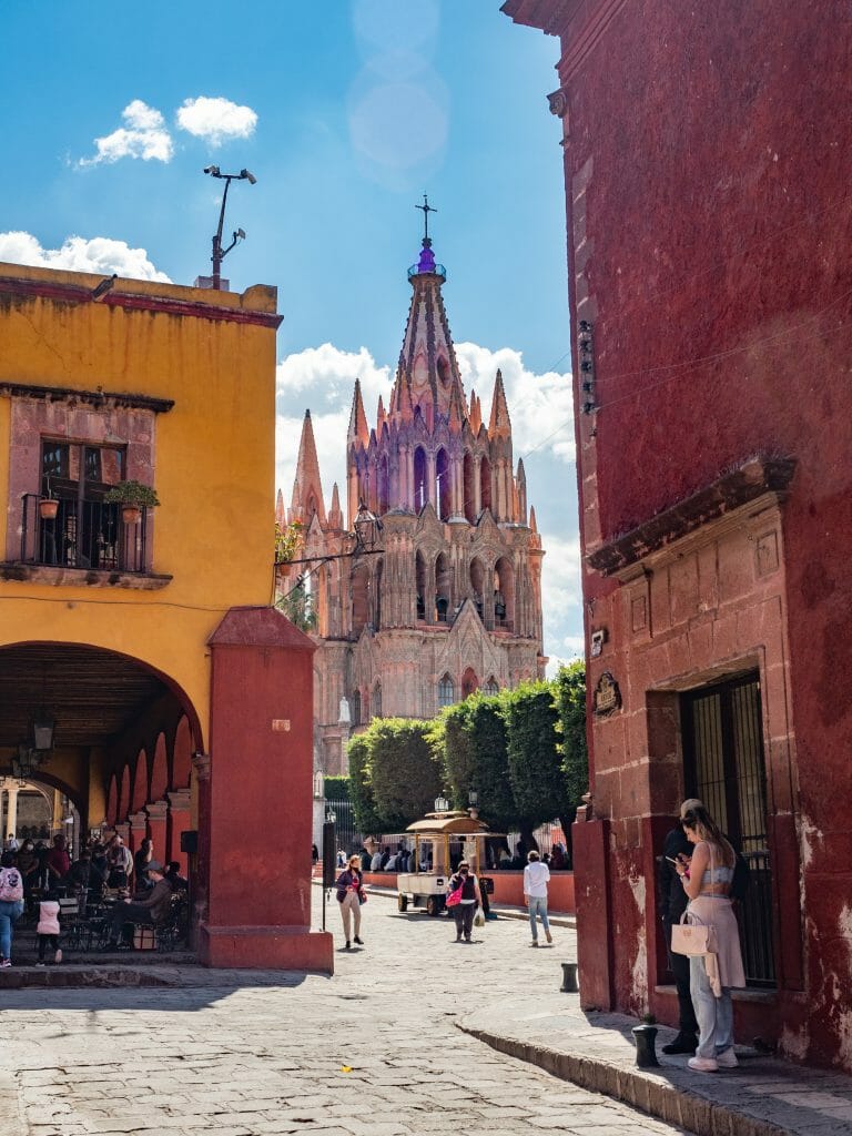
La Parroquia de San Miguel Arcángel, the iconic pink-hued church that dominates the central plaza and much of the surrounding skyline, was even more impressive in person.

And despite being midweek, the central plaza and surrounding gardens buzzed with a palpable energy as mariachi bands serenaded eager onlookers and all cameras pointed to the Parroquia.

San Miguel de Allende Guanajuato Mexico
La Parroquia de San Miguel Arcángel
San Miguel de Allende Guanajuato Mexico
La Parroquia visible from San Miguel’s colourful laneways

Unlike so many of the places we’ve travelled in Mexico thus far, SMA was notably full of gringos, a majority of whom are expats or retirees who’ve chosen to make their home in this colourful Mexican town.

The prices are somewhat reflective of that— substantially higher than nearby Guanajuato, but still very low compared to the US or Australia, hence the appeal. And what you’re paying for is one of the cleanest, safest, most international pueblos in Mexico, which to many is worth a few extra pesos and the sacrifice of a truly authentic local experience.

San Miguel de Allende Guanajuato Mexico
San Miguel de Allende
San Miguel de Allende Guanajuato Mexico
View from the incredible Luna Tapas Bar

With that in mind, we indulged in an incredible Lebanese lunch from Fenicia (the town is renowned for its varied worldwide cuisine) and cocktails from one of the city’s many rooftop bars.

As the sun descended over the colourful churches and leafy laneways, I couldn’t deny the beauty and oft-cited magic of San Miguel de Allende, but part of me also longed for the rough charm and grittiness that is characteristic of Mexico and yet notably absent from SMA. 

This was a wonderful visit, and I’m sure there will be many people hot on my heels for this, but I think we actually preferred the effortless charm of Guanajuato to the pristine beauty of San Miguel de Allende.

San Miguel de Allende Guanajuato Mexico

Where we stayed this week

Just to keep nearby destinations together within a single post, this weekly update runs from Tuesday to Tuesday:

  • Street parking in Tlaquepaque, Jalisco (free; 8 Feb)
  • Secure parking in the centre of Guadalajara, Jalisco (266p for 44hrs; 9-10 Feb)
  • Boondocking on a hill overlooking all of Guanajuato city, Guanajuato (free; 11 Feb)
  • Street parking on the shores of Presa de La Olla in Guanajuato, Guanajuato (free; 12 Feb)
  • MX Hotel in San Miguel de Allende, Guanajuato ($32USD per night; 13-14 Feb)
Guanajuato Mexico vanlife
Pipila Monument
TAGS:vanlifevanlife mexico
4 Comments
Share
brooke beyond

Hey, I'm Brooke and I'm obsessed with getting off the beaten path, exploring backcountry gems & travelling beyond the ordinary! I left Australia 5 years ago after finishing a PhD in Biomechanics & have been travelling the world full-time ever since (joined by my life/climbing partner, James). Whether it’s road-tripping through Mexico, climbing alpine peaks in the Andes, scuba diving in the Red Sea, or tackling epic via ferrata in the Dolomites, I hope this blog will inspire your future adventures & help you find wonder in every corner of the globe. xx bb

Leave a Comment Cancel Comment

The Comments

  • Michelle
    12 December 2023

    Would you prefer Tlaquepaque or SM de Allende?

    Reply
    • brooke brisbine
      Michelle
      15 December 2023

      Hi Michelle, that’s a seriously tough question!!

      I think I personally like Tlaquepaque a little more than San Miguel because the latter is a bit more upscale– it’s popular with retirees and expats, which makes the prices a little higher. But both are incredibly beautiful, full of amazing things to do, safe, clean, and in close proximity to fantastic larger cities. Tlaquepaque, for its part, is part of the greater city of Guadalajara, which is perhaps another benefit; San Miguel de Allende is 1hr from Guanajuato, one of my favourite cities in all of Mexico.

      Hope that helps a little!
      xx bb

      Reply
  • Gilberto M. Garcia
    12 April 2022

    Good morning Brooke, this is Gilbert Garcia, from tlaquepaque, I am reading your post from tlaquepaque right now, very nice, thanks for all your beautiful comments from mexico 🇲🇽, how Dan is doing, say hi for me, hope you guys are doing well, me and Julie are back in the states, for a while, we’ll be back in October, anyway enjoy your traveling wherever you guys are, be safe and God bless you and Don. This is my email, gilbertomgarcia@q.com, and 575 544 8037 thanks.

    Reply
    • brooke
      Gilberto M. Garcia
      20 April 2022

      Gilbert, I am SO happy you found my site! My phone still isn’t receiving text messages in Mexico for some unknown reason, but we wanted to thank you again for such a lovely afternoon in Tlaquepaque. We are currently in Chiapas and loving the jungle, although we’ll be glad to soon escape the heat 🙂

      Wishing you and Julie all the best, stay in touch
      xx Brooke + Dan

      Reply

You May Also Like

9 May 2025

Complete Salkantay Trek packing list: what to pack for hiking to Machu Picchu

8 March 2020

Absolutely everything you need to know about a land-based trip to the Galápagos (without a cruise)

5 April 2022

Vanlife diaries #56: Playa San Diego, Oaxaca to El Aguacero & Chiapa de Corzo, Chiapas Mexico

hi, I’m brooke!

I'm obsessed with getting off the beaten path, exploring backcountry gems & travelling beyond the ordinary! I left Australia 5 years ago after finishing a PhD in Biomechanics & have been travelling the world full-time ever since (now joined by my life/climbing partner, James). I hope this blog will inspire your future adventures & help you find wonder in every corner of the globe. xx bb

read my story
currently exploring

currently exploring

mexico

read our gear guides

🥾 hiking boots

🎒 hiking backpacks

🌨️ cold-weather layers

⛺️ backpacking & alpine tents

🛌 sleeping bag & pads

🍪 backcountry food

📸 travel camera gear

✈️ travel clothing

trail guides

summit guides

itineraries

outdoor gear

GPS maps

recent posts

  • Climbing Iztaccíhuatl volcano

    2-week Mexico volcanoes itinerary: climbing Pico de Orizaba, Izta, Malinche & Toluca

    3 June 2025
  • Mexico City: the perfect 5-day itinerary for CDMX

    31 May 2025
  • Climbing Iztaccíhuatl volcano

    Driving in Mexico: essential road trip guide for foreigners

    28 May 2025
  • 10-day Rwanda road trip itinerary: gorillas, volcanoes & Lake Kivu

    25 May 2025
  • 2-week Patagonia itinerary: best of Torres del Paine & Los Glaciares/El Chaltén

    22 May 2025

@brookebeyond_
brooke ✨travel & mountain gal

@brookebeyond_

  • NEW CUSTOM GPS MAPS!!

✨ shop.brookebeyond.com ✨

Before every single backpacking trip, hut-to-hut & alpine expedition, I spend dozens of hours on @caltopo building a GPS track to help me navigate along the route confidently, especially when venturing off the standard trail (which I nearly always do) 🗺️

And after MANY requests to share my custom routes, I now have 8 super detailed JSON/GPX files that you can use to plan your own epic adventure off the beaten path— navigating right off your smartphone!!!

Available maps:
🇮🇹 Alta Via 2
🇮🇹 Alta Via 4
🇫🇷 Mont Blanc Summit
🇵🇪 Huayhuash Circuit
🇦🇷 Aconcagua Summit
🇺🇸 Teton Crest Trail
🇨🇱 O-Circuit
🇦🇷 Fitz Roy Loop
+ more coming soon!

These maps include detailed route beta with hundreds of waypoints, essential trail stats, alternatives & bailouts, side-trips & summits, all based on my adventurous modifications to these amazing routes! 

They’ve been heavily tested by friends & readers, and I’m confident you won’t find another resource like them 🗺️

✨ shop.brookebeyond.com ✨

ps. If you’ve bought one of my maps this summer (AV2 + AV4 have been SO popular!), I’d love to hear from you!!
  • We took our own engagement photos in the Swiss Alps this summer and here’s how it went 👉🏼

(#8 might just be my personal fave 😂)

ALSO this post is for anyone who’s gotten the (woefully mistaken) impression that I am “naturally photogenic”
  • absolutely one of the most amazing little hikes we did in Switzerlnad this summer (& the competition was stiff) 🤩🏔️🌞🌸

📍Saxer Lücke

GETTING THERE: catch the Frümsen gondola to Staubernkanzel

HIKE: 1hr (2.5km, 250m gain) to this amazing viewpoint

WHEN TO GO: the best lighting is in the afternoon, these photos were taken around 4pm and it just kept getting better!
.
.
.
.
.
#swissalps #switzerland #saxerlücke #swisssummer #alpstein
  • the BEST easy hike in Zermatt 🏔️🥾✨

For spectacular views of the Matterhorn, the enormous Monte Rosa massif, and the Gorner Glacier (as well as 29 peaks over 4,000m!), there’s no better EASY hike than Riffelberg to Gornergrat, accessible via the Gornergrat Railway in Zermatt. 

The hike only takes about 2hrs at a leisurely pace (I did it 7 weeks after knee surgery!), so it’s suitable for families and non-hikers with even a basic level of fitness 🏃🏻‍♀️

🇨🇭 START FROM ZERMATT
- purchase tickets (day-of is fine) from Gornergrat Railway, right across from Zermatt train station

🚞 GORNERGRAT RAILWAY
- tickets from Zermatt to Riffelberg cost 42CHF ($50USD)— there’s no discount for return, so keep it flexible by purchasing one-way
- the train takes the about 25min, sit on the right side for best views!
- when you finish the hike at Gornergrat, buy a one-way ticket back to Zermatt for 66CHF ($80USD)
- save 50% on tickets with the Swiss Half Fare Card— the pass costs 120CHF ($150USD) and lasts for a whole month, it’s almost always worth it!) 

🥾 HIKE DETAILS: RIFFELSEE TO GORNERGRAT
- the route is 5km with 560m elevation gain (entirely uphill)
- the best views of the Matterhorn are around Riffelsee, where several small lakes offer perfect reflections
- near Rotenboden (the train station in between Riffelberg & Gornergrat), there are excellent rocky viewpoints of both Matterhorn and Monta Rosa— it’s easy to find quiet views if you hike around a bit!
- as you get closer to Gornergrat, Monte Rosa and the Gorner Glacier are right in your face
- almost everyone does this hike in reverse (Gornergrat to Riffelberg), I just personally hate hiking downhill— but you can swap if you’d rather descend the entire way!
  • 2 months after knee surgery and barely a week after I stopped walking with a knee brace and cane, I was honestly so proud to be able to do this (objectively very easy) 5km hike with 250m gain— it may not seem like much, but for me, this was a HUGE step forward 🥹

📍 Saxer Lücke, Switzerland 

it’s been an extremely challenging recovery, both physically and mentally… but the milestone moments always fill me with hope that things are indeed getting better ❤️‍🩹

special shoutout to my fiancé/hiking partner/personal cheering squad @slatojc for slowing down with me on the trail and always offering a hand down slippery rocks before I even have to ask
  • it’s another “if it wasn’t so stupid beautiful, I’d never set foot in this country again because it’s bleeding me dry” kinda summer 🇨🇭🌸☀️🏔️🦋✨

(hands up if you feel personally victimised by Swiss prices but you can’t stay away because MOUNTAINS 😭😭)
  • magical summer sunsets in Switzerland ✨
.
.
.
.
#swissalps #stoosridge #swisssummer #sunset
  • BEST EASY HIKES IN SWITZERLAND 🇨🇭❤️‍🩹

just 2 months after knee surgery, I found myself travelling through Switzerland— in search of easy hikes that were actually accessible post-op 🩼 

luckily, there’s hardly a better place in the world for easy hiking than the Swiss Alps!!

so whether you’re recovering from an injury, hiking with older parents/young children, or just a non-hiker who loves an epic view, this short list of HIGH VALUE viewpoints & hikes offer the most spectacular mountain scenery with minimal challenge

💸 BUDGET TIP: buy the Swiss Half Fare Card to save 50% all these gondolas and trains, which can seriously add up!!

- Stoos Ridge: take the Stoosbahn to the little village of Stoos + walk about 15min to the chairlift that can take you all the way up to Fronalpstock— you can walk as little or as much as you want up here, the views are amazing right away
- Riffelsee: take the Gornergrat Railway from Zermatt to Riffelsee + hike 20min to the 2 beautiful alpine lakes (then either hike 1hr up to Gornergrat or catch the train)
- Saxer Lücke: catch a gondola + hike 1hr (2.5km, 250m gain) to this amazing viewpoint— hardest on this list and not suitable for those with extremely limited mobility 
- Kleine Scheidegg: take the train or the gondola from Grindelwald + hike about 20min uphill to the lake
- Jungfraujoch: from Kleine Scheidegg, take the gondola to Jungfraujoch + walk around the viewing platforms
- Trockener Steg: take the gondola from Zermatt + walk 10min from the top of the cable car to the lake for incredible Matterhorn views
- Oeschinensee: 20min walk from the top of the Kandersteg cable car to the lake (bus also available), then you can walk as little or as much as you want around the lake or on the famous Panorama Trail
.
.
.
.
.
#easyhikes #swissalps #matterhorn #jungfraujoch #oeschinensee #stoos #switzerland
  • This is my 2nd summer back in Zermatt to climb the Matterhorn— and my 2nd summer NOT climbing the Matterhorn 😑

In 2023, a wicked snow storm blew through the night before my planned ascent and grounded all climbing parties… and then I had knee surgery less than 2 months before our repeat trip to Zermatt this year. I won’t lie, it’s been extremely disappointing to spend nearly 2 weeks in one of the most expensive places in the world, and STILL not do the thing I came here to do 😅

But alas, here we are in Zermatt again! (and apparently not for the last time)

Even though we are slowly going bankrupt, it’s a gorgeous place to be in the summer with no shortage of amazing trails!

Can’t wait to share some of what we’ve been up to— my first little hikes since surgery 🤩
follow @brookebeyond_

travel beyond the ordinary

Explore my travel guides, custom itineraries & blog posts with an interactive world map ✨

all destinations

  • NEW CUSTOM GPS MAPS!!

✨ shop.brookebeyond.com ✨

Before every single backpacking trip, hut-to-hut & alpine expedition, I spend dozens of hours on @caltopo building a GPS track to help me navigate along the route confidently, especially when venturing off the standard trail (which I nearly always do) 🗺️

And after MANY requests to share my custom routes, I now have 8 super detailed JSON/GPX files that you can use to plan your own epic adventure off the beaten path— navigating right off your smartphone!!!

Available maps:
🇮🇹 Alta Via 2
🇮🇹 Alta Via 4
🇫🇷 Mont Blanc Summit
🇵🇪 Huayhuash Circuit
🇦🇷 Aconcagua Summit
🇺🇸 Teton Crest Trail
🇨🇱 O-Circuit
🇦🇷 Fitz Roy Loop
+ more coming soon!

These maps include detailed route beta with hundreds of waypoints, essential trail stats, alternatives & bailouts, side-trips & summits, all based on my adventurous modifications to these amazing routes! 

They’ve been heavily tested by friends & readers, and I’m confident you won’t find another resource like them 🗺️

✨ shop.brookebeyond.com ✨

ps. If you’ve bought one of my maps this summer (AV2 + AV4 have been SO popular!), I’d love to hear from you!!
  • We took our own engagement photos in the Swiss Alps this summer and here’s how it went 👉🏼

(#8 might just be my personal fave 😂)

ALSO this post is for anyone who’s gotten the (woefully mistaken) impression that I am “naturally photogenic”
  • absolutely one of the most amazing little hikes we did in Switzerlnad this summer (& the competition was stiff) 🤩🏔️🌞🌸

📍Saxer Lücke

GETTING THERE: catch the Frümsen gondola to Staubernkanzel

HIKE: 1hr (2.5km, 250m gain) to this amazing viewpoint

WHEN TO GO: the best lighting is in the afternoon, these photos were taken around 4pm and it just kept getting better!
.
.
.
.
.
#swissalps #switzerland #saxerlücke #swisssummer #alpstein
  • the BEST easy hike in Zermatt 🏔️🥾✨

For spectacular views of the Matterhorn, the enormous Monte Rosa massif, and the Gorner Glacier (as well as 29 peaks over 4,000m!), there’s no better EASY hike than Riffelberg to Gornergrat, accessible via the Gornergrat Railway in Zermatt. 

The hike only takes about 2hrs at a leisurely pace (I did it 7 weeks after knee surgery!), so it’s suitable for families and non-hikers with even a basic level of fitness 🏃🏻‍♀️

🇨🇭 START FROM ZERMATT
- purchase tickets (day-of is fine) from Gornergrat Railway, right across from Zermatt train station

🚞 GORNERGRAT RAILWAY
- tickets from Zermatt to Riffelberg cost 42CHF ($50USD)— there’s no discount for return, so keep it flexible by purchasing one-way
- the train takes the about 25min, sit on the right side for best views!
- when you finish the hike at Gornergrat, buy a one-way ticket back to Zermatt for 66CHF ($80USD)
- save 50% on tickets with the Swiss Half Fare Card— the pass costs 120CHF ($150USD) and lasts for a whole month, it’s almost always worth it!) 

🥾 HIKE DETAILS: RIFFELSEE TO GORNERGRAT
- the route is 5km with 560m elevation gain (entirely uphill)
- the best views of the Matterhorn are around Riffelsee, where several small lakes offer perfect reflections
- near Rotenboden (the train station in between Riffelberg & Gornergrat), there are excellent rocky viewpoints of both Matterhorn and Monta Rosa— it’s easy to find quiet views if you hike around a bit!
- as you get closer to Gornergrat, Monte Rosa and the Gorner Glacier are right in your face
- almost everyone does this hike in reverse (Gornergrat to Riffelberg), I just personally hate hiking downhill— but you can swap if you’d rather descend the entire way!
  • 2 months after knee surgery and barely a week after I stopped walking with a knee brace and cane, I was honestly so proud to be able to do this (objectively very easy) 5km hike with 250m gain— it may not seem like much, but for me, this was a HUGE step forward 🥹

📍 Saxer Lücke, Switzerland 

it’s been an extremely challenging recovery, both physically and mentally… but the milestone moments always fill me with hope that things are indeed getting better ❤️‍🩹

special shoutout to my fiancé/hiking partner/personal cheering squad @slatojc for slowing down with me on the trail and always offering a hand down slippery rocks before I even have to ask
NEW CUSTOM GPS MAPS!!

✨ shop.brookebeyond.com ✨

Before every single backpacking trip, hut-to-hut & alpine expedition, I spend dozens of hours on @caltopo building a GPS track to help me navigate along the route confidently, especially when venturing off the standard trail (which I nearly always do) 🗺️

And after MANY requests to share my custom routes, I now have 8 super detailed JSON/GPX files that you can use to plan your own epic adventure off the beaten path— navigating right off your smartphone!!!

Available maps:
🇮🇹 Alta Via 2
🇮🇹 Alta Via 4
🇫🇷 Mont Blanc Summit
🇵🇪 Huayhuash Circuit
🇦🇷 Aconcagua Summit
🇺🇸 Teton Crest Trail
🇨🇱 O-Circuit
🇦🇷 Fitz Roy Loop
+ more coming soon!

These maps include detailed route beta with hundreds of waypoints, essential trail stats, alternatives & bailouts, side-trips & summits, all based on my adventurous modifications to these amazing routes! 

They’ve been heavily tested by friends & readers, and I’m confident you won’t find another resource like them 🗺️

✨ shop.brookebeyond.com ✨

ps. If you’ve bought one of my maps this summer (AV2 + AV4 have been SO popular!), I’d love to hear from you!!
@brookebeyond_
@brookebeyond_
•
Follow
NEW CUSTOM GPS MAPS!! ✨ shop.brookebeyond.com ✨ Before every single backpacking trip, hut-to-hut & alpine expedition, I spend dozens of hours on @caltopo building a GPS track to help me navigate along the route confidently, especially when venturing off the standard trail (which I nearly always do) 🗺️ And after MANY requests to share my custom routes, I now have 8 super detailed JSON/GPX files that you can use to plan your own epic adventure off the beaten path— navigating right off your smartphone!!! Available maps: 🇮🇹 Alta Via 2 🇮🇹 Alta Via 4 🇫🇷 Mont Blanc Summit 🇵🇪 Huayhuash Circuit 🇦🇷 Aconcagua Summit 🇺🇸 Teton Crest Trail 🇨🇱 O-Circuit 🇦🇷 Fitz Roy Loop + more coming soon! These maps include detailed route beta with hundreds of waypoints, essential trail stats, alternatives & bailouts, side-trips & summits, all based on my adventurous modifications to these amazing routes! They’ve been heavily tested by friends & readers, and I’m confident you won’t find another resource like them 🗺️ ✨ shop.brookebeyond.com ✨ ps. If you’ve bought one of my maps this summer (AV2 + AV4 have been SO popular!), I’d love to hear from you!!
1 day ago
View on Instagram |
1/5
We took our own engagement photos in the Swiss Alps this summer and here’s how it went 👉🏼

(#8 might just be my personal fave 😂)

ALSO this post is for anyone who’s gotten the (woefully mistaken) impression that I am “naturally photogenic”
We took our own engagement photos in the Swiss Alps this summer and here’s how it went 👉🏼

(#8 might just be my personal fave 😂)

ALSO this post is for anyone who’s gotten the (woefully mistaken) impression that I am “naturally photogenic”
We took our own engagement photos in the Swiss Alps this summer and here’s how it went 👉🏼

(#8 might just be my personal fave 😂)

ALSO this post is for anyone who’s gotten the (woefully mistaken) impression that I am “naturally photogenic”
We took our own engagement photos in the Swiss Alps this summer and here’s how it went 👉🏼

(#8 might just be my personal fave 😂)

ALSO this post is for anyone who’s gotten the (woefully mistaken) impression that I am “naturally photogenic”
We took our own engagement photos in the Swiss Alps this summer and here’s how it went 👉🏼

(#8 might just be my personal fave 😂)

ALSO this post is for anyone who’s gotten the (woefully mistaken) impression that I am “naturally photogenic”
We took our own engagement photos in the Swiss Alps this summer and here’s how it went 👉🏼

(#8 might just be my personal fave 😂)

ALSO this post is for anyone who’s gotten the (woefully mistaken) impression that I am “naturally photogenic”
We took our own engagement photos in the Swiss Alps this summer and here’s how it went 👉🏼

(#8 might just be my personal fave 😂)

ALSO this post is for anyone who’s gotten the (woefully mistaken) impression that I am “naturally photogenic”
We took our own engagement photos in the Swiss Alps this summer and here’s how it went 👉🏼

(#8 might just be my personal fave 😂)

ALSO this post is for anyone who’s gotten the (woefully mistaken) impression that I am “naturally photogenic”
We took our own engagement photos in the Swiss Alps this summer and here’s how it went 👉🏼

(#8 might just be my personal fave 😂)

ALSO this post is for anyone who’s gotten the (woefully mistaken) impression that I am “naturally photogenic”
We took our own engagement photos in the Swiss Alps this summer and here’s how it went 👉🏼

(#8 might just be my personal fave 😂)

ALSO this post is for anyone who’s gotten the (woefully mistaken) impression that I am “naturally photogenic”
@brookebeyond_
@brookebeyond_
•
Follow
We took our own engagement photos in the Swiss Alps this summer and here’s how it went 👉🏼 (#8 might just be my personal fave 😂) ALSO this post is for anyone who’s gotten the (woefully mistaken) impression that I am “naturally photogenic”
4 days ago
View on Instagram |
2/5
@brookebeyond_
@brookebeyond_
•
Follow
absolutely one of the most amazing little hikes we did in Switzerlnad this summer (& the competition was stiff) 🤩🏔️🌞🌸 📍Saxer Lücke GETTING THERE: catch the Frümsen gondola to Staubernkanzel HIKE: 1hr (2.5km, 250m gain) to this amazing viewpoint WHEN TO GO: the best lighting is in the afternoon, these photos were taken around 4pm and it just kept getting better! . . . . . #swissalps #switzerland #saxerlücke #swisssummer #alpstein
5 days ago
View on Instagram |
3/5
the BEST easy hike in Zermatt 🏔️🥾✨

For spectacular views of the Matterhorn, the enormous Monte Rosa massif, and the Gorner Glacier (as well as 29 peaks over 4,000m!), there’s no better EASY hike than Riffelberg to Gornergrat, accessible via the Gornergrat Railway in Zermatt. 

The hike only takes about 2hrs at a leisurely pace (I did it 7 weeks after knee surgery!), so it’s suitable for families and non-hikers with even a basic level of fitness 🏃🏻‍♀️

🇨🇭 START FROM ZERMATT
- purchase tickets (day-of is fine) from Gornergrat Railway, right across from Zermatt train station

🚞 GORNERGRAT RAILWAY
- tickets from Zermatt to Riffelberg cost 42CHF ($50USD)— there’s no discount for return, so keep it flexible by purchasing one-way
- the train takes the about 25min, sit on the right side for best views!
- when you finish the hike at Gornergrat, buy a one-way ticket back to Zermatt for 66CHF ($80USD)
- save 50% on tickets with the Swiss Half Fare Card— the pass costs 120CHF ($150USD) and lasts for a whole month, it’s almost always worth it!) 

🥾 HIKE DETAILS: RIFFELSEE TO GORNERGRAT
- the route is 5km with 560m elevation gain (entirely uphill)
- the best views of the Matterhorn are around Riffelsee, where several small lakes offer perfect reflections
- near Rotenboden (the train station in between Riffelberg & Gornergrat), there are excellent rocky viewpoints of both Matterhorn and Monta Rosa— it’s easy to find quiet views if you hike around a bit!
- as you get closer to Gornergrat, Monte Rosa and the Gorner Glacier are right in your face
- almost everyone does this hike in reverse (Gornergrat to Riffelberg), I just personally hate hiking downhill— but you can swap if you’d rather descend the entire way!
@brookebeyond_
@brookebeyond_
•
Follow
the BEST easy hike in Zermatt 🏔️🥾✨ For spectacular views of the Matterhorn, the enormous Monte Rosa massif, and the Gorner Glacier (as well as 29 peaks over 4,000m!), there’s no better EASY hike than Riffelberg to Gornergrat, accessible via the Gornergrat Railway in Zermatt. The hike only takes about 2hrs at a leisurely pace (I did it 7 weeks after knee surgery!), so it’s suitable for families and non-hikers with even a basic level of fitness 🏃🏻‍♀️ 🇨🇭 START FROM ZERMATT - purchase tickets (day-of is fine) from Gornergrat Railway, right across from Zermatt train station 🚞 GORNERGRAT RAILWAY - tickets from Zermatt to Riffelberg cost 42CHF ($50USD)— there’s no discount for return, so keep it flexible by purchasing one-way - the train takes the about 25min, sit on the right side for best views! - when you finish the hike at Gornergrat, buy a one-way ticket back to Zermatt for 66CHF ($80USD) - save 50% on tickets with the Swiss Half Fare Card— the pass costs 120CHF ($150USD) and lasts for a whole month, it’s almost always worth it!) 🥾 HIKE DETAILS: RIFFELSEE TO GORNERGRAT - the route is 5km with 560m elevation gain (entirely uphill) - the best views of the Matterhorn are around Riffelsee, where several small lakes offer perfect reflections - near Rotenboden (the train station in between Riffelberg & Gornergrat), there are excellent rocky viewpoints of both Matterhorn and Monta Rosa— it’s easy to find quiet views if you hike around a bit! - as you get closer to Gornergrat, Monte Rosa and the Gorner Glacier are right in your face - almost everyone does this hike in reverse (Gornergrat to Riffelberg), I just personally hate hiking downhill— but you can swap if you’d rather descend the entire way!
2 weeks ago
View on Instagram |
4/5
2 months after knee surgery and barely a week after I stopped walking with a knee brace and cane, I was honestly so proud to be able to do this (objectively very easy) 5km hike with 250m gain— it may not seem like much, but for me, this was a HUGE step forward 🥹

📍 Saxer Lücke, Switzerland 

it’s been an extremely challenging recovery, both physically and mentally… but the milestone moments always fill me with hope that things are indeed getting better ❤️‍🩹

special shoutout to my fiancé/hiking partner/personal cheering squad @slatojc for slowing down with me on the trail and always offering a hand down slippery rocks before I even have to ask
@brookebeyond_
@brookebeyond_
•
Follow
2 months after knee surgery and barely a week after I stopped walking with a knee brace and cane, I was honestly so proud to be able to do this (objectively very easy) 5km hike with 250m gain— it may not seem like much, but for me, this was a HUGE step forward 🥹 📍 Saxer Lücke, Switzerland it’s been an extremely challenging recovery, both physically and mentally… but the milestone moments always fill me with hope that things are indeed getting better ❤️‍🩹 special shoutout to my fiancé/hiking partner/personal cheering squad @slatojc for slowing down with me on the trail and always offering a hand down slippery rocks before I even have to ask
3 weeks ago
View on Instagram |
5/5

  • start here
  • about
  • group trips
  • destinations
  • hiking guides
  • outdoor gear
  • custom GPS maps
  • privacy
  • contact

COPYRIGHT © 2025 BROOKE BEYOND. TRAVEL BEYOND THE ORDINARY. Site Powered by Pix & Hue.


Loading Comments...