• start here
  • about
  • group trips
  • brooke beyond

  • hiking guides
  • outdoor gear
    • hiking boots
    • hiking backpacks
    • cold-weather layers
    • backpacking tent
    • outdoor sleep system
    • backcountry food
    • day-hike packing list
    • hut-to-hut packing list
    • via ferrata packing list
    • backpacking packing list
    • mountaineering packing list

brooke beyond

Zion National Park itinerary best hikes Subway
USA / Utah

Everything you need to know about hiking the Subway (bottom up) in Zion National Park

24 May 2021

Last Updated on 27 November 2023

Of all the incredible hikes within Zion National Park, the Subway, a hollowed-out sandstone gorge resembling an underground tunnel, is one of the most spectacular— and also one of the most highly sought-after.

Elusive wilderness permits greatly restrict visitors to the canyon, and technical terrain further limits who can experience the otherworldly splendour of this remote cave and its emerald pools. As tricky as it is to access, though, the Subway is all the more magical for being off the beaten path and far from the crowds of Zion Canyon.

In addition to a highly technical canyoneering route that approaches the Subway from above, those lucky enough to score a permit also have the option of a challenging but non-technical 9.5mi hike to reach the Subway. Here’s absolutely everything you need to know about hiking the Subway “bottom up”, including how to get to the trailhead, what to wear for your hike, and insider tips on getting a permit!

What's in this guide

Toggle
  • About Zion National Park
    • Getting to Zion National Park
    • Getting to the Left Fork (Subway)
    • Entrance fees for Zion National Park
  • Preparing for the Subway (bottom up) hike
    • How to get a Left Fork (Subway) Permit
    • Tips for getting a last-minute permit
    • What to wear for hiking the Subway
    • Other important things to know about the Subway
  • Hiking the Subway (bottom up) in Zion National Park

About Zion National Park

Getting to Zion National Park

Located in southern Utah near the Arizona border, Zion National Park is within easy reach of several major cities and their airports, including Las Vegas (3hrs) and Salt Lake City (5hrs).

The park is also 1hr from Bryce Canyon and 30min from Kanab, Utah (via the east entrance), which together with Page, Arizona forms the southwest’s major adventure hub! In short, Zion is incredibly accessible and not to be missed.

Zion National Park itinerary best hikes Angel's Landing
The easy section of the hike to Angel’s Landing

Getting to the Left Fork (Subway)

Access to hike the Subway (bottom up) is from the Left Fork trailhead on Kolob Terrace Road, around the west side of the park near Virgin, Utah (30min from the Visitor Centre).

The excellent news is that you won’t have to fight for a carpark or worry about shuttle tickets, since the Subway is outside of Zion Canyon and therefore off the main tourist path! Limited daily permits (80 people max) also ensure that this is a far more backcountry adventure than other popular hikes in Zion, like Angel’s Landing and the Narrows.

Zion National Park itinerary best hikes biking Zion Canyon
Biking over the river on Pa’rus Trail

Entrance fees for Zion National Park

As with the entire NPS network, there are fees associated with visiting Zion National Park. If you are only exploring the park for a single week and not planning to visit any other national parks in the next year, you can purchase a 7-day access pass for $35USD at either the south or east entrance stations.

If you plan on visiting more than 3 US national sites in the next 12 months, it’s actually cheaper to get an annual parks pass for $80USD, accepted at all 63 national parks and thousands of other national monuments and forests around the country.

Purchase your America the Beautiful Pass at the visitor centres and entrance stations (south and east entrance), at Recreation.gov, or even in-store or online from outdoor retailers like REI.

Zion National Park itinerary best hikes Subway
The Subway

Preparing for the Subway (bottom up) hike

How to get a Left Fork (Subway) Permit

Getting a permit is 90% of the struggle when it comes to hiking the Subway, and therefore this is probably the MOST important section of this entire post.

There are 80 total spots available each day to access Left Fork (Subway); 60 of these spots are available in advance and 20 become available in the days leading up to a given trip date. Multiple people can be on the same permit, but the allocation is based on total hikers (max 80) rather than a set number of permits (i.e. the park will continue issuing permits until they reach 80 people).

Theoretically, there are 4 ways you can obtain a Wilderness Permit for the Subway, and these are the same regardless of whether you’re hiking “bottom up” or canyoneering “top down”:

1. Advance Lottery (2 months prior to your trip): You can apply online for one of 60 available Left Fork (Subway) permits for trips in April to October, providing 3 date options in order of preference. By the 5th of the following month, you should hear back as to whether your application was successful.

2. Calendar Reservations (1 month prior to your trip): In the event that there are permits remaining after the Advance Lottery, you can directly reserve dates for the upcoming month starting on the 5th of each month at 10am MT and continuing until all 60 advance permits are exhausted.

3. Last-Minute Drawing (7-2 days prior to your trip): 7 days ahead of any given trip date, 20 additional last-minute permits become available for the Left Fork (Subway), which you can enter to win up until 2 days prior (by 12pm MT) as part of an online lottery system. Winners are announced 2 days prior at 1pm MT (1hr after the lottery closes).

4. Walk-up Permits (2-0 days prior to your trip): As soon as the Last-Minute Drawing concludes, any remaining or cancelled permits will be accessible by walking up to the Wilderness Desk (right next to the Zion Visitor Centre; hours 7am-5pm). This is usually a good bet, since permits do get cancelled when multiple people in the same group win (e.g. Dan and I both enter for 2 people, we both win, 1 of us “returns” 2 spots for use on another permit).

With the exception of Walk-up Permits (#4 above), all other methods of applying for a permit involve a non-refundable $5 fee, 100% of which stays within Zion (and therefore you can think of this as a donation rather than a waste of money if you’re unsuccessful).

If you ARE successful, the permit also costs $15 (1-2 people), $20 (up to 7 people), or $25 (up to 12 people), payable at the Wilderness Desk upon collection of your permit.

Zion National Park itinerary best hikes Subway
Hiking to the Subway

Tips for getting a last-minute permit

For those trying to get a Left Fork (Subway) permit closer to their trip dates, your only 2 options are the Last-Minute Drawing or Walk-Up.

We entered the Last-Minute Drawing five times, believing this was our best chance at securing a permit, and lost every single time— there were usually 150+ people vying for the 20 remaining spots, and it’s not to say that the lottery is a waste of time, but it helps to have realistic expectations. This is VERY competitive!

After speaking to multiple Zion rangers, we eventually learned that there are almost always last-minute cancellations that result in additional permits being made available as a Walk-Up. You’ll definitely still need luck to score one of these permits, as there’s no set release time— I might cancel a permit at 11pm, and therefore 2 spots become available to the first person at the Wilderness Desk at 7am the following day, but I also might cancel a permit at 4pm, and therefore 2 spots become available after 4pm (that weren’t available at 7am).

Walk-Up is a massive gamble and there’s no way to predict when people are going to cancel, BUT this is how we finally got our permit:

Dan got in line at 630am and talked to the group just behind him, who were decreasing the number of people on their permit due to friends bailing— if he hadn’t let them go first to make the cancellation, we wouldn’t have been able to snag 2 of the newly-available spots for that day!

Key things to consider:

  • Being there early doesn’t guarantee you’re going to get a permit, since groups cancel all throughout the day. Talk to people in line and be prepared to wait several hours if no one has cancelled yet that day.
  • You can get a permit for the day OF or the day PRIOR to your trip (anytime after the Last-Minute Lottery, which draws 2 days prior at 1pm MT), so it’s good to keep your schedule open.
  • If you do enter the Last-Minute Lottery, every person in your party is allowed to submit an application, thereby increasing your chance of winning (e.g. Dan and I both submitted applications for 2 people; had both of us won, we would have “returned” 2 spots). Again, think of the $5 fee as a donation to the park!
Zion National Park itinerary best hikes Subway
Left Fork of North Creek

What to wear for hiking the Subway

In addition to comfortable athletic clothes, your footwear is pretty crucial when hiking the Subway. While you can definitely complete the trail in regular hiking boots and rock-hop across the creek to stay dry, there are sections (right as you approach the Subway, specifically) where it’s truly impossible NOT to get wet.

Consequently, I’d recommend either wearing a pair of neoprene socks under your hiking boots OR renting canyoneering gear from Zion Outfitter, just outside the South Entrance of the park in Springdale.

Again, you don’t have to wear specialised boots for this hike, but I think it made the experience a lot more fun to be able to romp through the water and swim around at the Subway in boots designed to handle slippery rocks.

The “warm weather” rental package from Zion Outfitter is $29 for neoprene socks and boots, and we were honestly SO happy to have the grip (these boots have an astounding amount of traction, even when wet!) and the ankle support, as well as sparing our own hiking boots the trauma of walking through the sandy creek all day.

Zion National Park itinerary best hikes Subway
Canyoneering boots were a good choice!

Other important things to know about the Subway

  • BOTTOM UP VS TOP DOWN: In addition to the “bottom up” route described here, which is a non-technical hike to reach the Subway, you can also access the sandstone gorge via a classic “top down” canyoneering route. This technical option requires significantly more time, energy, and equipment, so only attempt if you have prior canyoneering experience!
  • FACILITIES: There are toilets at the Left Fork trailhead, but no water— come prepared with at least 4L per person!
  • CYANOBACTERIA: In late 2020, Zion National Park issued a Danger Advisory for the North Fork of the Virgin River, North Creek, and La Verkin Creek due to the presence of harmful cyanobacteria and cyanotoxins in these three major tributaries of the Virgin River. This doesn’t mean you can’t hike to the Subway, but you should shower after contact with the water, take care not to submerge your head, and avoid ingesting any river water, even after filtration.
  • LEAVE NO TRACE: 84% of Zion National Park is designated as Wilderness, the highest level of protection for public land, which is why the permitting system is so incredibly tight. As with every outdoor adventure, and particularly those within protected Wilderness areas, it is critical that you take steps to reduce human impact on the environment. This includes packing out all of your rubbish and being mindful of where you go off-trail— it’s absolutely part of the adventure, but not at the expense of delicate plantlife, so be sure to get your off-route kicks on the rocks or other durable surfaces.
Zion National Park itinerary best hikes Subway
The Subway

Hiking the Subway (bottom up) in Zion National Park

At 9.1 miles and 1305ft of elevation gain, the Subway isn’t an overly long or steep hike, but it still takes the better part of a day, thanks to the terrain (heaps of creek crossings and narrow, rocky trails along the bank) and the beautiful scenery (which will have you stopping every few minutes to take photos).

The Alltrails map below is a useful reference to download for your hike, but the trail follows North Creek the entire way into the Subway, so it would be nearly impossible to get lost or off-route— when in doubt, just hop into the water and head upstream!

Setting off from the Left Fork trailhead on Kolob Terrace Road, the trail begins with a steep, rocky descent to North Creek.

This is the most challenging part of the hike, in my opinion, with loose stones making it tricky to get good footing— still, it’s a relatively quick drop into the creek, where the going gets much easier!

Zion National Park itinerary best hikes Subway
Descending towards the Left Fork of North Creek

At the end of the steep trail leading down to North Creek, you’ll see a sign indicating the Left Fork Trailhead back up the way you came— turn left here to walk along the riverbank and begin your Subway hike in earnest.

Zion National Park itinerary best hikes Subway

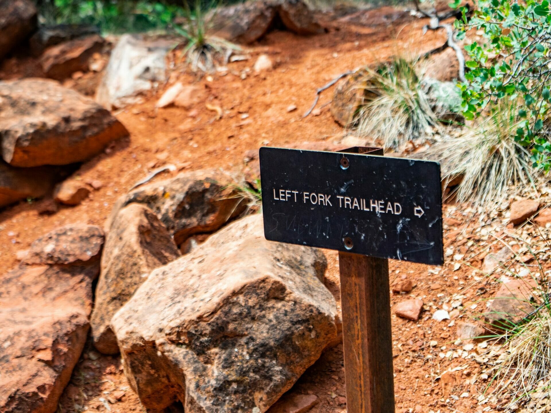
I’ve read a few different accounts of the Subway where people said this sign (pictured above) was easy to miss on the return journey, but we didn’t have any trouble spotting our trail, nor did we think the route was confusing.

As long as you’re paying a tiny bit of attention when you near the junction, you should have absolutely no issue making your way back to the trailhead at the end of the day.

Zion National Park itinerary best hikes Subway

From here, faint trails zigzag along both sides of North Creek, heading upstream towards the Subway.

There’s not really one “right” route, but try to walk on worn paths and avoid any sections that have been blocked off by branches, thus minimising side trails and allowing for restoration of trampled plantlife.

Zion National Park itinerary best hikes Subway

During the first three-quarters of the hike, it’s possible to stay dry by rock-hopping across the creek and opting for paths along the bank, but I actually found it far more fun to walk through the water and explore this incredible riparian ecosystem— the entire journey is punctuated by vibrant wildflowers, golden frogs, small fish, and an explosion of green foliage, all best enjoyed from the creek itself.

Hardly a minute went by that we weren’t admiring some rare bird or splashing through a beautiful waterfall, and all the while, we saw only a few other groups of hikers headed back from the Subway, enjoying rare solitude in the country’s third-busiest national park.

Zion National Park itinerary best hikes Subway
Entrance to the Subway

After several hours of enjoyable hiking along (and through) North Creek, you’ll eventually notice the canyon walls begin to narrow overhead and the trail incline slightly towards the base of the canyon wall.

A series of wide, flat waterfalls announce the entrance to the Subway, and before you know it, you’re entering the namesake feature, which is even more spectacular than it’s possible to describe.

Zion National Park itinerary best hikes Subway

True to its name, this cylindrical sandstone gorge bears a striking resemblance to a subway tunnel— and with wind rushing through, it even feels like you’re waiting for an underground train.

In addition to the semi-circular canyon wall and the warm glow of light that filters through, almost like the beam of a Subway approaching, deep pools cut into the rock slab make for a truly otherworldly scene.

Zion National Park itinerary best hikes Subway
Exploring the Subway

This is the kind of place that’s immediately worth any trouble it took to reach.

And for all the times we cursed the permitting limits, you wouldn’t want one extra person here— the opportunity to explore without other hikers on your heels is a big part of what makes the Subway so impressive.

Zion National Park itinerary best hikes Subway
Swimming through the Subway in Zion

For those who want to wring every ounce of fun out of the Subway, hop into the pools at the back of the canyon and scramble/swim through the narrow walls and around the bend, where a hidden waterfall greets only the most eager of explorers.

Although cold, it’s VERY worth getting wet and seeing the Subway in its entirety, something usually reserved for canyoneering groups. The only hard part will be leaving for the return hike!

Zion National Park itinerary best hikes Subway
Me and Dan at the Subway

Read more about Utah

THE ULTIMATE 1-DAY ZION NATIONAL PARK ITINERARY: 9 BEST HIKES & VIEWPOINTS (POST-COVID)

5 INCREDIBLE WAYS TO EXPLORE ZION NATIONAL PARK

8 AMAZING HIKES IN ZION NATIONAL PARK

THE ULTIMATE 1-DAY CANYONLANDS NATIONAL PARK ITINERARY: DRUID ARCH HIKE & BEST VIEWPOINTS (POST-COVID)

THE ULTIMATE 1-DAY ARCHES NATIONAL PARK ITINERARY: 17 BEST VIEWPOINTS & HIKES (POST-COVID)

THE BEST HALF-DAY CANYONEERING TOUR WITH EAST ZION EXPERIENCES

AN EPIC AFTERNOON OF CLIMBING AT LAMBS KNOLL WITH ROCK ODYSSEYS

TAGS:trail guidestravel guidesUS national parks
2 Comments
Share
brooke beyond

Hey, I'm Brooke and I'm obsessed with getting off the beaten path, exploring backcountry gems & travelling beyond the ordinary! I left Australia 5 years ago after finishing a PhD in Biomechanics & have been travelling the world full-time ever since (joined by my life/climbing partner, James). Whether it’s road-tripping through Mexico, climbing alpine peaks in the Andes, scuba diving in the Red Sea, or tackling epic via ferrata in the Dolomites, I hope this blog will inspire your future adventures & help you find wonder in every corner of the globe. xx bb

Leave a Comment Cancel Comment

The Comments

  • Tarsha Cheek
    7 October 2023

    When did you go? It looks hot by the way that you are dressed. And was the water frigid or just cold?

    Reply
    • brooke brisbine
      Tarsha Cheek
      16 November 2023

      Thanks for reading, Marsha!

      It was definitely hot in May, a great time to go– since the water was indeed freezing!

      Happy trails,
      xx bb

      Reply

You May Also Like

7 May 2021

Vanlife diaries #8: Saguaro National Park East & the Superstitions

3 August 2021

15 best hikes in the Sawtooth National Forest (+ an extensive guide to Stanley, Idaho)

12 April 2021

8 awesome day hikes in Joshua Tree National Park

hi, I’m brooke!

I'm obsessed with getting off the beaten path, exploring backcountry gems & travelling beyond the ordinary! I left Australia 5 years ago after finishing a PhD in Biomechanics & have been travelling the world full-time ever since (now joined by my life/climbing partner, James). I hope this blog will inspire your future adventures & help you find wonder in every corner of the globe. xx bb

read my story
currently exploring

currently exploring

mexico

read our gear guides

🥾 hiking boots

🎒 hiking backpacks

🌨️ cold-weather layers

⛺️ backpacking & alpine tents

🛌 sleeping bag & pads

🍪 backcountry food

📸 travel camera gear

✈️ travel clothing

trail guides

summit guides

itineraries

outdoor gear

GPS maps

recent posts

  • Climbing Iztaccíhuatl volcano

    2-week Mexico volcanoes itinerary: climbing Pico de Orizaba, Izta, Malinche & Toluca

    3 June 2025
  • Mexico City: the perfect 5-day itinerary for CDMX

    31 May 2025
  • Climbing Iztaccíhuatl volcano

    Driving in Mexico: essential road trip guide for foreigners

    28 May 2025
  • 10-day Rwanda road trip itinerary: gorillas, volcanoes & Lake Kivu

    25 May 2025
  • 2-week Patagonia itinerary: best of Torres del Paine & Los Glaciares/El Chaltén

    22 May 2025

@brookebeyond_
brooke ✨travel & mountain gal

@brookebeyond_

  • magical moments in the swiss alps 🐄🇨🇭🧀🫐🌺
.
.
.
.
.
#swissalps #switzerland #matterhorn #zermatt #oeschinensee #lucerne #jungfraujoch #grindelwald #swisssummer
  • NEW CUSTOM GPS MAPS!!

✨ shop.brookebeyond.com ✨

Before every single backpacking trip, hut-to-hut & alpine expedition, I spend dozens of hours on @caltopo building a GPS track to help me navigate along the route confidently, especially when venturing off the standard trail (which I nearly always do) 🗺️

And after MANY requests to share my custom routes, I now have 8 super detailed JSON/GPX files that you can use to plan your own epic adventure off the beaten path— navigating right off your smartphone!!!

Available maps:
🇮🇹 Alta Via 2
🇮🇹 Alta Via 4
🇫🇷 Mont Blanc Summit
🇵🇪 Huayhuash Circuit
🇦🇷 Aconcagua Summit
🇺🇸 Teton Crest Trail
🇨🇱 O-Circuit
🇦🇷 Fitz Roy Loop
+ more coming soon!

These maps include detailed route beta with hundreds of waypoints, essential trail stats, alternatives & bailouts, side-trips & summits, all based on my adventurous modifications to these amazing routes! 

They’ve been heavily tested by friends & readers, and I’m confident you won’t find another resource like them 🗺️

✨ shop.brookebeyond.com ✨

ps. If you’ve bought one of my maps this summer (AV2 + AV4 have been SO popular!), I’d love to hear from you!!
  • We took our own engagement photos in the Swiss Alps this summer and here’s how it went 👉🏼

(#8 might just be my personal fave 😂)

ALSO this post is for anyone who’s gotten the (woefully mistaken) impression that I am “naturally photogenic”
  • absolutely one of the most amazing little hikes we did in Switzerlnad this summer (& the competition was stiff) 🤩🏔️🌞🌸

📍Saxer Lücke

GETTING THERE: catch the Frümsen gondola to Staubernkanzel

HIKE: 1hr (2.5km, 250m gain) to this amazing viewpoint

WHEN TO GO: the best lighting is in the afternoon, these photos were taken around 4pm and it just kept getting better!
.
.
.
.
.
#swissalps #switzerland #saxerlücke #swisssummer #alpstein
  • the BEST easy hike in Zermatt 🏔️🥾✨

For spectacular views of the Matterhorn, the enormous Monte Rosa massif, and the Gorner Glacier (as well as 29 peaks over 4,000m!), there’s no better EASY hike than Riffelberg to Gornergrat, accessible via the Gornergrat Railway in Zermatt. 

The hike only takes about 2hrs at a leisurely pace (I did it 7 weeks after knee surgery!), so it’s suitable for families and non-hikers with even a basic level of fitness 🏃🏻‍♀️

🇨🇭 START FROM ZERMATT
- purchase tickets (day-of is fine) from Gornergrat Railway, right across from Zermatt train station

🚞 GORNERGRAT RAILWAY
- tickets from Zermatt to Riffelberg cost 42CHF ($50USD)— there’s no discount for return, so keep it flexible by purchasing one-way
- the train takes the about 25min, sit on the right side for best views!
- when you finish the hike at Gornergrat, buy a one-way ticket back to Zermatt for 66CHF ($80USD)
- save 50% on tickets with the Swiss Half Fare Card— the pass costs 120CHF ($150USD) and lasts for a whole month, it’s almost always worth it!) 

🥾 HIKE DETAILS: RIFFELSEE TO GORNERGRAT
- the route is 5km with 560m elevation gain (entirely uphill)
- the best views of the Matterhorn are around Riffelsee, where several small lakes offer perfect reflections
- near Rotenboden (the train station in between Riffelberg & Gornergrat), there are excellent rocky viewpoints of both Matterhorn and Monta Rosa— it’s easy to find quiet views if you hike around a bit!
- as you get closer to Gornergrat, Monte Rosa and the Gorner Glacier are right in your face
- almost everyone does this hike in reverse (Gornergrat to Riffelberg), I just personally hate hiking downhill— but you can swap if you’d rather descend the entire way!
  • 2 months after knee surgery and barely a week after I stopped walking with a knee brace and cane, I was honestly so proud to be able to do this (objectively very easy) 5km hike with 250m gain— it may not seem like much, but for me, this was a HUGE step forward 🥹

📍 Saxer Lücke, Switzerland 

it’s been an extremely challenging recovery, both physically and mentally… but the milestone moments always fill me with hope that things are indeed getting better ❤️‍🩹

special shoutout to my fiancé/hiking partner/personal cheering squad @slatojc for slowing down with me on the trail and always offering a hand down slippery rocks before I even have to ask
  • it’s another “if it wasn’t so stupid beautiful, I’d never set foot in this country again because it’s bleeding me dry” kinda summer 🇨🇭🌸☀️🏔️🦋✨

(hands up if you feel personally victimised by Swiss prices but you can’t stay away because MOUNTAINS 😭😭)
  • magical summer sunsets in Switzerland ✨
.
.
.
.
#swissalps #stoosridge #swisssummer #sunset
  • BEST EASY HIKES IN SWITZERLAND 🇨🇭❤️‍🩹

just 2 months after knee surgery, I found myself travelling through Switzerland— in search of easy hikes that were actually accessible post-op 🩼 

luckily, there’s hardly a better place in the world for easy hiking than the Swiss Alps!!

so whether you’re recovering from an injury, hiking with older parents/young children, or just a non-hiker who loves an epic view, this short list of HIGH VALUE viewpoints & hikes offer the most spectacular mountain scenery with minimal challenge

💸 BUDGET TIP: buy the Swiss Half Fare Card to save 50% all these gondolas and trains, which can seriously add up!!

- Stoos Ridge: take the Stoosbahn to the little village of Stoos + walk about 15min to the chairlift that can take you all the way up to Fronalpstock— you can walk as little or as much as you want up here, the views are amazing right away
- Riffelsee: take the Gornergrat Railway from Zermatt to Riffelsee + hike 20min to the 2 beautiful alpine lakes (then either hike 1hr up to Gornergrat or catch the train)
- Saxer Lücke: catch a gondola + hike 1hr (2.5km, 250m gain) to this amazing viewpoint— hardest on this list and not suitable for those with extremely limited mobility 
- Kleine Scheidegg: take the train or the gondola from Grindelwald + hike about 20min uphill to the lake
- Jungfraujoch: from Kleine Scheidegg, take the gondola to Jungfraujoch + walk around the viewing platforms
- Trockener Steg: take the gondola from Zermatt + walk 10min from the top of the cable car to the lake for incredible Matterhorn views
- Oeschinensee: 20min walk from the top of the Kandersteg cable car to the lake (bus also available), then you can walk as little or as much as you want around the lake or on the famous Panorama Trail
.
.
.
.
.
#easyhikes #swissalps #matterhorn #jungfraujoch #oeschinensee #stoos #switzerland
follow @brookebeyond_

travel beyond the ordinary

Explore my travel guides, custom itineraries & blog posts with an interactive world map ✨

all destinations

  • magical moments in the swiss alps 🐄🇨🇭🧀🫐🌺
.
.
.
.
.
#swissalps #switzerland #matterhorn #zermatt #oeschinensee #lucerne #jungfraujoch #grindelwald #swisssummer
  • NEW CUSTOM GPS MAPS!!

✨ shop.brookebeyond.com ✨

Before every single backpacking trip, hut-to-hut & alpine expedition, I spend dozens of hours on @caltopo building a GPS track to help me navigate along the route confidently, especially when venturing off the standard trail (which I nearly always do) 🗺️

And after MANY requests to share my custom routes, I now have 8 super detailed JSON/GPX files that you can use to plan your own epic adventure off the beaten path— navigating right off your smartphone!!!

Available maps:
🇮🇹 Alta Via 2
🇮🇹 Alta Via 4
🇫🇷 Mont Blanc Summit
🇵🇪 Huayhuash Circuit
🇦🇷 Aconcagua Summit
🇺🇸 Teton Crest Trail
🇨🇱 O-Circuit
🇦🇷 Fitz Roy Loop
+ more coming soon!

These maps include detailed route beta with hundreds of waypoints, essential trail stats, alternatives & bailouts, side-trips & summits, all based on my adventurous modifications to these amazing routes! 

They’ve been heavily tested by friends & readers, and I’m confident you won’t find another resource like them 🗺️

✨ shop.brookebeyond.com ✨

ps. If you’ve bought one of my maps this summer (AV2 + AV4 have been SO popular!), I’d love to hear from you!!
  • We took our own engagement photos in the Swiss Alps this summer and here’s how it went 👉🏼

(#8 might just be my personal fave 😂)

ALSO this post is for anyone who’s gotten the (woefully mistaken) impression that I am “naturally photogenic”
  • absolutely one of the most amazing little hikes we did in Switzerlnad this summer (& the competition was stiff) 🤩🏔️🌞🌸

📍Saxer Lücke

GETTING THERE: catch the Frümsen gondola to Staubernkanzel

HIKE: 1hr (2.5km, 250m gain) to this amazing viewpoint

WHEN TO GO: the best lighting is in the afternoon, these photos were taken around 4pm and it just kept getting better!
.
.
.
.
.
#swissalps #switzerland #saxerlücke #swisssummer #alpstein
  • the BEST easy hike in Zermatt 🏔️🥾✨

For spectacular views of the Matterhorn, the enormous Monte Rosa massif, and the Gorner Glacier (as well as 29 peaks over 4,000m!), there’s no better EASY hike than Riffelberg to Gornergrat, accessible via the Gornergrat Railway in Zermatt. 

The hike only takes about 2hrs at a leisurely pace (I did it 7 weeks after knee surgery!), so it’s suitable for families and non-hikers with even a basic level of fitness 🏃🏻‍♀️

🇨🇭 START FROM ZERMATT
- purchase tickets (day-of is fine) from Gornergrat Railway, right across from Zermatt train station

🚞 GORNERGRAT RAILWAY
- tickets from Zermatt to Riffelberg cost 42CHF ($50USD)— there’s no discount for return, so keep it flexible by purchasing one-way
- the train takes the about 25min, sit on the right side for best views!
- when you finish the hike at Gornergrat, buy a one-way ticket back to Zermatt for 66CHF ($80USD)
- save 50% on tickets with the Swiss Half Fare Card— the pass costs 120CHF ($150USD) and lasts for a whole month, it’s almost always worth it!) 

🥾 HIKE DETAILS: RIFFELSEE TO GORNERGRAT
- the route is 5km with 560m elevation gain (entirely uphill)
- the best views of the Matterhorn are around Riffelsee, where several small lakes offer perfect reflections
- near Rotenboden (the train station in between Riffelberg & Gornergrat), there are excellent rocky viewpoints of both Matterhorn and Monta Rosa— it’s easy to find quiet views if you hike around a bit!
- as you get closer to Gornergrat, Monte Rosa and the Gorner Glacier are right in your face
- almost everyone does this hike in reverse (Gornergrat to Riffelberg), I just personally hate hiking downhill— but you can swap if you’d rather descend the entire way!
magical moments in the swiss alps 🐄🇨🇭🧀🫐🌺
.
.
.
.
.
#swissalps #switzerland #matterhorn #zermatt #oeschinensee #lucerne #jungfraujoch #grindelwald #swisssummer
magical moments in the swiss alps 🐄🇨🇭🧀🫐🌺
.
.
.
.
.
#swissalps #switzerland #matterhorn #zermatt #oeschinensee #lucerne #jungfraujoch #grindelwald #swisssummer
magical moments in the swiss alps 🐄🇨🇭🧀🫐🌺
.
.
.
.
.
#swissalps #switzerland #matterhorn #zermatt #oeschinensee #lucerne #jungfraujoch #grindelwald #swisssummer
magical moments in the swiss alps 🐄🇨🇭🧀🫐🌺
.
.
.
.
.
#swissalps #switzerland #matterhorn #zermatt #oeschinensee #lucerne #jungfraujoch #grindelwald #swisssummer
magical moments in the swiss alps 🐄🇨🇭🧀🫐🌺
.
.
.
.
.
#swissalps #switzerland #matterhorn #zermatt #oeschinensee #lucerne #jungfraujoch #grindelwald #swisssummer
magical moments in the swiss alps 🐄🇨🇭🧀🫐🌺
.
.
.
.
.
#swissalps #switzerland #matterhorn #zermatt #oeschinensee #lucerne #jungfraujoch #grindelwald #swisssummer
magical moments in the swiss alps 🐄🇨🇭🧀🫐🌺
.
.
.
.
.
#swissalps #switzerland #matterhorn #zermatt #oeschinensee #lucerne #jungfraujoch #grindelwald #swisssummer
magical moments in the swiss alps 🐄🇨🇭🧀🫐🌺
.
.
.
.
.
#swissalps #switzerland #matterhorn #zermatt #oeschinensee #lucerne #jungfraujoch #grindelwald #swisssummer
magical moments in the swiss alps 🐄🇨🇭🧀🫐🌺
.
.
.
.
.
#swissalps #switzerland #matterhorn #zermatt #oeschinensee #lucerne #jungfraujoch #grindelwald #swisssummer
magical moments in the swiss alps 🐄🇨🇭🧀🫐🌺
.
.
.
.
.
#swissalps #switzerland #matterhorn #zermatt #oeschinensee #lucerne #jungfraujoch #grindelwald #swisssummer
magical moments in the swiss alps 🐄🇨🇭🧀🫐🌺
.
.
.
.
.
#swissalps #switzerland #matterhorn #zermatt #oeschinensee #lucerne #jungfraujoch #grindelwald #swisssummer
magical moments in the swiss alps 🐄🇨🇭🧀🫐🌺
.
.
.
.
.
#swissalps #switzerland #matterhorn #zermatt #oeschinensee #lucerne #jungfraujoch #grindelwald #swisssummer
magical moments in the swiss alps 🐄🇨🇭🧀🫐🌺
.
.
.
.
.
#swissalps #switzerland #matterhorn #zermatt #oeschinensee #lucerne #jungfraujoch #grindelwald #swisssummer
@brookebeyond_
@brookebeyond_
•
Follow
magical moments in the swiss alps 🐄🇨🇭🧀🫐🌺 . . . . . #swissalps #switzerland #matterhorn #zermatt #oeschinensee #lucerne #jungfraujoch #grindelwald #swisssummer
1 day ago
View on Instagram |
1/5
NEW CUSTOM GPS MAPS!!

✨ shop.brookebeyond.com ✨

Before every single backpacking trip, hut-to-hut & alpine expedition, I spend dozens of hours on @caltopo building a GPS track to help me navigate along the route confidently, especially when venturing off the standard trail (which I nearly always do) 🗺️

And after MANY requests to share my custom routes, I now have 8 super detailed JSON/GPX files that you can use to plan your own epic adventure off the beaten path— navigating right off your smartphone!!!

Available maps:
🇮🇹 Alta Via 2
🇮🇹 Alta Via 4
🇫🇷 Mont Blanc Summit
🇵🇪 Huayhuash Circuit
🇦🇷 Aconcagua Summit
🇺🇸 Teton Crest Trail
🇨🇱 O-Circuit
🇦🇷 Fitz Roy Loop
+ more coming soon!

These maps include detailed route beta with hundreds of waypoints, essential trail stats, alternatives & bailouts, side-trips & summits, all based on my adventurous modifications to these amazing routes! 

They’ve been heavily tested by friends & readers, and I’m confident you won’t find another resource like them 🗺️

✨ shop.brookebeyond.com ✨

ps. If you’ve bought one of my maps this summer (AV2 + AV4 have been SO popular!), I’d love to hear from you!!
@brookebeyond_
@brookebeyond_
•
Follow
NEW CUSTOM GPS MAPS!! ✨ shop.brookebeyond.com ✨ Before every single backpacking trip, hut-to-hut & alpine expedition, I spend dozens of hours on @caltopo building a GPS track to help me navigate along the route confidently, especially when venturing off the standard trail (which I nearly always do) 🗺️ And after MANY requests to share my custom routes, I now have 8 super detailed JSON/GPX files that you can use to plan your own epic adventure off the beaten path— navigating right off your smartphone!!! Available maps: 🇮🇹 Alta Via 2 🇮🇹 Alta Via 4 🇫🇷 Mont Blanc Summit 🇵🇪 Huayhuash Circuit 🇦🇷 Aconcagua Summit 🇺🇸 Teton Crest Trail 🇨🇱 O-Circuit 🇦🇷 Fitz Roy Loop + more coming soon! These maps include detailed route beta with hundreds of waypoints, essential trail stats, alternatives & bailouts, side-trips & summits, all based on my adventurous modifications to these amazing routes! They’ve been heavily tested by friends & readers, and I’m confident you won’t find another resource like them 🗺️ ✨ shop.brookebeyond.com ✨ ps. If you’ve bought one of my maps this summer (AV2 + AV4 have been SO popular!), I’d love to hear from you!!
3 days ago
View on Instagram |
2/5
We took our own engagement photos in the Swiss Alps this summer and here’s how it went 👉🏼

(#8 might just be my personal fave 😂)

ALSO this post is for anyone who’s gotten the (woefully mistaken) impression that I am “naturally photogenic”
We took our own engagement photos in the Swiss Alps this summer and here’s how it went 👉🏼

(#8 might just be my personal fave 😂)

ALSO this post is for anyone who’s gotten the (woefully mistaken) impression that I am “naturally photogenic”
We took our own engagement photos in the Swiss Alps this summer and here’s how it went 👉🏼

(#8 might just be my personal fave 😂)

ALSO this post is for anyone who’s gotten the (woefully mistaken) impression that I am “naturally photogenic”
We took our own engagement photos in the Swiss Alps this summer and here’s how it went 👉🏼

(#8 might just be my personal fave 😂)

ALSO this post is for anyone who’s gotten the (woefully mistaken) impression that I am “naturally photogenic”
We took our own engagement photos in the Swiss Alps this summer and here’s how it went 👉🏼

(#8 might just be my personal fave 😂)

ALSO this post is for anyone who’s gotten the (woefully mistaken) impression that I am “naturally photogenic”
We took our own engagement photos in the Swiss Alps this summer and here’s how it went 👉🏼

(#8 might just be my personal fave 😂)

ALSO this post is for anyone who’s gotten the (woefully mistaken) impression that I am “naturally photogenic”
We took our own engagement photos in the Swiss Alps this summer and here’s how it went 👉🏼

(#8 might just be my personal fave 😂)

ALSO this post is for anyone who’s gotten the (woefully mistaken) impression that I am “naturally photogenic”
We took our own engagement photos in the Swiss Alps this summer and here’s how it went 👉🏼

(#8 might just be my personal fave 😂)

ALSO this post is for anyone who’s gotten the (woefully mistaken) impression that I am “naturally photogenic”
We took our own engagement photos in the Swiss Alps this summer and here’s how it went 👉🏼

(#8 might just be my personal fave 😂)

ALSO this post is for anyone who’s gotten the (woefully mistaken) impression that I am “naturally photogenic”
We took our own engagement photos in the Swiss Alps this summer and here’s how it went 👉🏼

(#8 might just be my personal fave 😂)

ALSO this post is for anyone who’s gotten the (woefully mistaken) impression that I am “naturally photogenic”
@brookebeyond_
@brookebeyond_
•
Follow
We took our own engagement photos in the Swiss Alps this summer and here’s how it went 👉🏼 (#8 might just be my personal fave 😂) ALSO this post is for anyone who’s gotten the (woefully mistaken) impression that I am “naturally photogenic”
6 days ago
View on Instagram |
3/5
@brookebeyond_
@brookebeyond_
•
Follow
absolutely one of the most amazing little hikes we did in Switzerlnad this summer (& the competition was stiff) 🤩🏔️🌞🌸 📍Saxer Lücke GETTING THERE: catch the Frümsen gondola to Staubernkanzel HIKE: 1hr (2.5km, 250m gain) to this amazing viewpoint WHEN TO GO: the best lighting is in the afternoon, these photos were taken around 4pm and it just kept getting better! . . . . . #swissalps #switzerland #saxerlücke #swisssummer #alpstein
1 week ago
View on Instagram |
4/5
the BEST easy hike in Zermatt 🏔️🥾✨

For spectacular views of the Matterhorn, the enormous Monte Rosa massif, and the Gorner Glacier (as well as 29 peaks over 4,000m!), there’s no better EASY hike than Riffelberg to Gornergrat, accessible via the Gornergrat Railway in Zermatt. 

The hike only takes about 2hrs at a leisurely pace (I did it 7 weeks after knee surgery!), so it’s suitable for families and non-hikers with even a basic level of fitness 🏃🏻‍♀️

🇨🇭 START FROM ZERMATT
- purchase tickets (day-of is fine) from Gornergrat Railway, right across from Zermatt train station

🚞 GORNERGRAT RAILWAY
- tickets from Zermatt to Riffelberg cost 42CHF ($50USD)— there’s no discount for return, so keep it flexible by purchasing one-way
- the train takes the about 25min, sit on the right side for best views!
- when you finish the hike at Gornergrat, buy a one-way ticket back to Zermatt for 66CHF ($80USD)
- save 50% on tickets with the Swiss Half Fare Card— the pass costs 120CHF ($150USD) and lasts for a whole month, it’s almost always worth it!) 

🥾 HIKE DETAILS: RIFFELSEE TO GORNERGRAT
- the route is 5km with 560m elevation gain (entirely uphill)
- the best views of the Matterhorn are around Riffelsee, where several small lakes offer perfect reflections
- near Rotenboden (the train station in between Riffelberg & Gornergrat), there are excellent rocky viewpoints of both Matterhorn and Monta Rosa— it’s easy to find quiet views if you hike around a bit!
- as you get closer to Gornergrat, Monte Rosa and the Gorner Glacier are right in your face
- almost everyone does this hike in reverse (Gornergrat to Riffelberg), I just personally hate hiking downhill— but you can swap if you’d rather descend the entire way!
@brookebeyond_
@brookebeyond_
•
Follow
the BEST easy hike in Zermatt 🏔️🥾✨ For spectacular views of the Matterhorn, the enormous Monte Rosa massif, and the Gorner Glacier (as well as 29 peaks over 4,000m!), there’s no better EASY hike than Riffelberg to Gornergrat, accessible via the Gornergrat Railway in Zermatt. The hike only takes about 2hrs at a leisurely pace (I did it 7 weeks after knee surgery!), so it’s suitable for families and non-hikers with even a basic level of fitness 🏃🏻‍♀️ 🇨🇭 START FROM ZERMATT - purchase tickets (day-of is fine) from Gornergrat Railway, right across from Zermatt train station 🚞 GORNERGRAT RAILWAY - tickets from Zermatt to Riffelberg cost 42CHF ($50USD)— there’s no discount for return, so keep it flexible by purchasing one-way - the train takes the about 25min, sit on the right side for best views! - when you finish the hike at Gornergrat, buy a one-way ticket back to Zermatt for 66CHF ($80USD) - save 50% on tickets with the Swiss Half Fare Card— the pass costs 120CHF ($150USD) and lasts for a whole month, it’s almost always worth it!) 🥾 HIKE DETAILS: RIFFELSEE TO GORNERGRAT - the route is 5km with 560m elevation gain (entirely uphill) - the best views of the Matterhorn are around Riffelsee, where several small lakes offer perfect reflections - near Rotenboden (the train station in between Riffelberg & Gornergrat), there are excellent rocky viewpoints of both Matterhorn and Monta Rosa— it’s easy to find quiet views if you hike around a bit! - as you get closer to Gornergrat, Monte Rosa and the Gorner Glacier are right in your face - almost everyone does this hike in reverse (Gornergrat to Riffelberg), I just personally hate hiking downhill— but you can swap if you’d rather descend the entire way!
2 weeks ago
View on Instagram |
5/5

  • start here
  • about
  • group trips
  • destinations
  • hiking guides
  • outdoor gear
  • custom GPS maps
  • privacy
  • contact

COPYRIGHT © 2025 BROOKE BEYOND. TRAVEL BEYOND THE ORDINARY. Site Powered by Pix & Hue.


Loading Comments...