• start here
  • about
  • group trips
  • brooke beyond

  • hiking guides
  • outdoor gear
    • hiking boots
    • hiking backpacks
    • cold-weather layers
    • backpacking tent
    • outdoor sleep system
    • backcountry food
    • day-hike packing list
    • hut-to-hut packing list
    • via ferrata packing list
    • backpacking packing list
    • mountaineering packing list

brooke beyond

Latin America / Peru

Highlights from 10 days on the Huayhuash Circuit

1 December 2019

Last Updated on 22 October 2021

There is absolutely no high like coming off the trail after a long hike— dead-tired, covered in dirt, but with a feeling of accomplishment that almost makes you savour the pain of aching muscles and bleeding feet, as if they are some sort of hard-earned badge.

The Huayhuash Circuit pushed me well beyond the limits of what I thought I could do, but I’ve also never seen rugged natural beauty quite like the Cordillera Huayhuash. I was obsessed with making it over the next mountain pass just to see what alpine lake or dramatic peak was waiting for me, even if it felt like I would collapse from sheer exhaustion. I battled constantly for these views, which only made them that much sweeter. Out of a million incredible moments, here are my absolute favourite highlights from independently hiking the Huayhuash Circuit this August.

Planning your own independent Huayhuash Circuit trek without a guide or tour? Check out my comprehensive guide: THE ULTIMATE GUIDE TO INDEPENDENT & SOLO HIKING THE HUAYHUASH CIRCUIT IN PERU

Scenic camping on the shores of Laguna Mitucocha

Wild camping at Laguna Mitucocha

Our first night on the Huayhuash Circuit was spent in one of the most memorable spots, wild camping on the shores of Laguna Mitucocha. The day had been a bit unruly and insanely windy as we crested over Cacananpunta, the first high mountain pass of the trip, but as we descended into the valley, everything was instantly peaceful— no howling wind, no stormy weather swirling overhead, not another soul in sight, just a glassy lake and an equally polished blue sky over the dramatic summit of Jirishanca. The perfect spot to set up camp.

Amazing texture above Laguna Mitucocha

Ruta alpina from Mitucocha

Although we’d taken our first trail variation on the previous day, the ruta alpina from Mitucocha to Carhuacocha was a much longer and more challenging deviation from the traditional Huayhuash Circuit track, and probably a lot more representative of a true “high route”. We spent about 95% of the day looking for the trail (ANY trail), even getting so lost that we had to climb up the side of the mountain— which is no easy task with a full pack.

Our route was convoluted and messy and definitely not direct (or even correct), but there was no denying that it had been worth it when we got to the top of the ridgeline and looked back over the valley. The smooth blue of Laguna Mitucocha stretched out between the rippled andesite cliffs and their yellow alpine tundra, making for the most incredible sea of texture. I could hardly decide where to look.

Laguna Carchuacocha camp

The view from Laguna Carhuacocha

Plagued with afternoon clouds, we arrived into camp on the shore of Laguna Carhuacocha to see a whole lot of … nothing. This was meant to be one of the most scenic campsites, but the view of Siula Grande and Yerupajá, two of the Huayhuash’s most spectacular peaks, was entirely obstructed by thick, grey clouds at the end of the lake.

A trekking guide from the neighbouring guided group befriended our family as we were setting up camp, inviting us to join him in their large communal tent for some afternoon tea and mountain stories. Just as I was walking over to the tent with Marco, I turned around to see the clouds parting with incredible speed, revealing more of Siula Grande and Yerupajá with every second.

I had no idea how long I’d have to enjoy the scene, so I legged it back to our tent, littering the campsite with my belongings as I went, and grabbed dad just in time to get a photo. Only moments later, the clouds swirled back in and hid the mountains once more, but I felt like Pachamama had called off the bad weather, if even just for a moment, so that I could get this view. The dramatic reveal was pretty spectacular.

Tres Lagunas

Clouds lifting from Siula Grande

Mirador Tres Lagunas

Mirador Tres Lagunas was such an incredible highlight of the Huayhuash Circuit, it was a view I’d been dreaming of since I first started planning this trek— but I woke up this morning to find that low-hanging clouds, the same that had appeared yesterday afternoon, were still blocking all mountain views. I hung around camp at Laguna Carhuacocha for hours hoping things would clear, very fittingly reading Touching the Void as I looked out over the water, silently begging for wind that would lift the fog and sun that could burn off the clouds. By 9am, things hadn’t moved at all and I couldn’t delay my departure any longer.

The parents opted to take a lower route since dad was feeling unwell, so I set off around the lake by myself. No sooner had I started moving, though, than a small hole of blue sky appeared in what had previously been a solid sheet of dark, fluffy clouds. Slowly but increasing with every step, the summit of Yerupajá and Siula Grande were revealed. Exactly like last night, it felt as if this was nature turning it on just for me.

The climb to this mirador was unrelenting and my heavy pack did not help matters, but I raced up and managed to enjoy a small window of reasonable weather at the top. By the time I got to Siula Pass another few hundred metres above, the moment had already passed and clouds were rolling in again, but I was BEYOND excited to have gotten this view. It may not have been the perfect sunny conditions I was dreaming of, but it was almost more spectacular watching these peaks appear out of the clouds.

Frolicking below Nevado Carnicero

Running around beneath Punta Carnicero

Any time I took my backpack off on the trail, it felt like I was almost weightless, like I might just float away now that my pack wasn’t there to anchor my feet firmly to the dirt. Even at a breathless 5,000m pass, I couldn’t suppress the urge to ditch the pack and run whenever I saw something wonderful, suddenly full of energy regardless of how exhausting the previous hours had been.

The temptation was rarely greater than when I saw these giant spongy tufts of grass scattered beneath Carnicero— I was overcome with the need to jump on them, and I needed to get there 5 seconds ago to do it. So off I went.

Viconga hot springs

One of the hardest parts of spending 10 days on the trail, possibly even harder than carrying an 18kg backpack or getting a second degree sunburn on the backs of my hands, was not showering for a week and a half. By the end of the trip, I didn’t even want to touch my own hair because it felt like a slimy dead animal..

But on day 4, I got to practically boil the layers of dirt and grime off myself in a steamy hot spring and it was the best feeling in the world. I spent hours soaking in the water, even returning after dinner to enjoy good conversation and a cold Cusqueño in the pools under a spectacularly clear sky and more stars than I’d ever seen in my life. Everything about this night reminded me of how special the mountains are, but also left me with a lot of big questions about my next move. Staring up at the Milky Way made me feel like anything was possible, though, and like I still have the capacity to completely surprise myself.

Punta Cuyoc

Punta Cuyoc

On a day where the highlight was, in my mind, not to come until much later, I was amazed to crest over Punta Cuyoc and find a hulking glacier that felt close enough to touch. The conditions couldn’t have been more perfect, and the feeling of discovering great beauty in an unexpected place left me overflowing. This was a reminder that there is so much more to every trip than the “highlights” you read about beforehand and the spots you build up in your mind— often the best and most memorable moments are born from a complete lack of expectation.

A challenging climb to San Antonio Pass

Paso San Antonio

Climbing Paso San Antonio

After a reasonably full day on the trail, no one at camp was keen to spend several hours side-tripping to 5,050m Paso San Antonio with me— except Marco, the trekking guide we’d met previously, whose clients were all happily napping in their tents. We smashed out the agonisingly steep climb to the pass in good time, even if it did feel like I had to pull myself up the final 100m using nothing but my trekking poles (had my legs finally ceased to function?).

But reaching the top of the pass wasn’t enough. Marco led me onwards, climbing and scrambling up the rocks to an even higher point over the pass— and then we just sat. For what felt like hours, I looked out at Siula Grande, Yerupajá, and Laguna Jaraucocha below. Save for the gentle rush of wind over the pass and the slow, steady drift of clouds in the distance, everything was completely silent and perfectly still.

It’s pretty rare that anyone just sits these days, not listening to music or looking at a phone or doing something, but I felt entirely consumed by the view, like I couldn’t have possibly done anything else in that moment but sit and try to take it all in.

Everything about the scene felt completely raw and wild, and I was overcome by the power of nature to create things that could make “real life” feel so far away. In actual fact, though, this IS real life, more real than my routines or insecurities or closets full of stuff back home. All these things seemed to fade into the background, dwarfed by the fierce, powerful peaks stretched out around me. The ultimate reminder of how small our problems really are.

Descending Paso San Antonio in the snow

A snowy morning at Cuyoc

Not satisfied with just one transformative experience atop Paso San Antonio, I woke in the freezing cold and pitch black of the following morning to climb the pass again for sunrise. The view was every bit as magical as the previous day, but this time, after tearing away from the incredible scenery, we descended through falling snow and little flurries towards a camp blanketed in white.

From above, the brightly coloured tents looked like props in a snow globe, almost absurdly tiny nestled below the tall, powder-dusted mountains that flanked the valley. The campsite was entirely transformed from yesterday, and even though snow might not make for the best trekking conditions, its unexpected appearance made me feel like a kid who’d just woken up to a snow day.

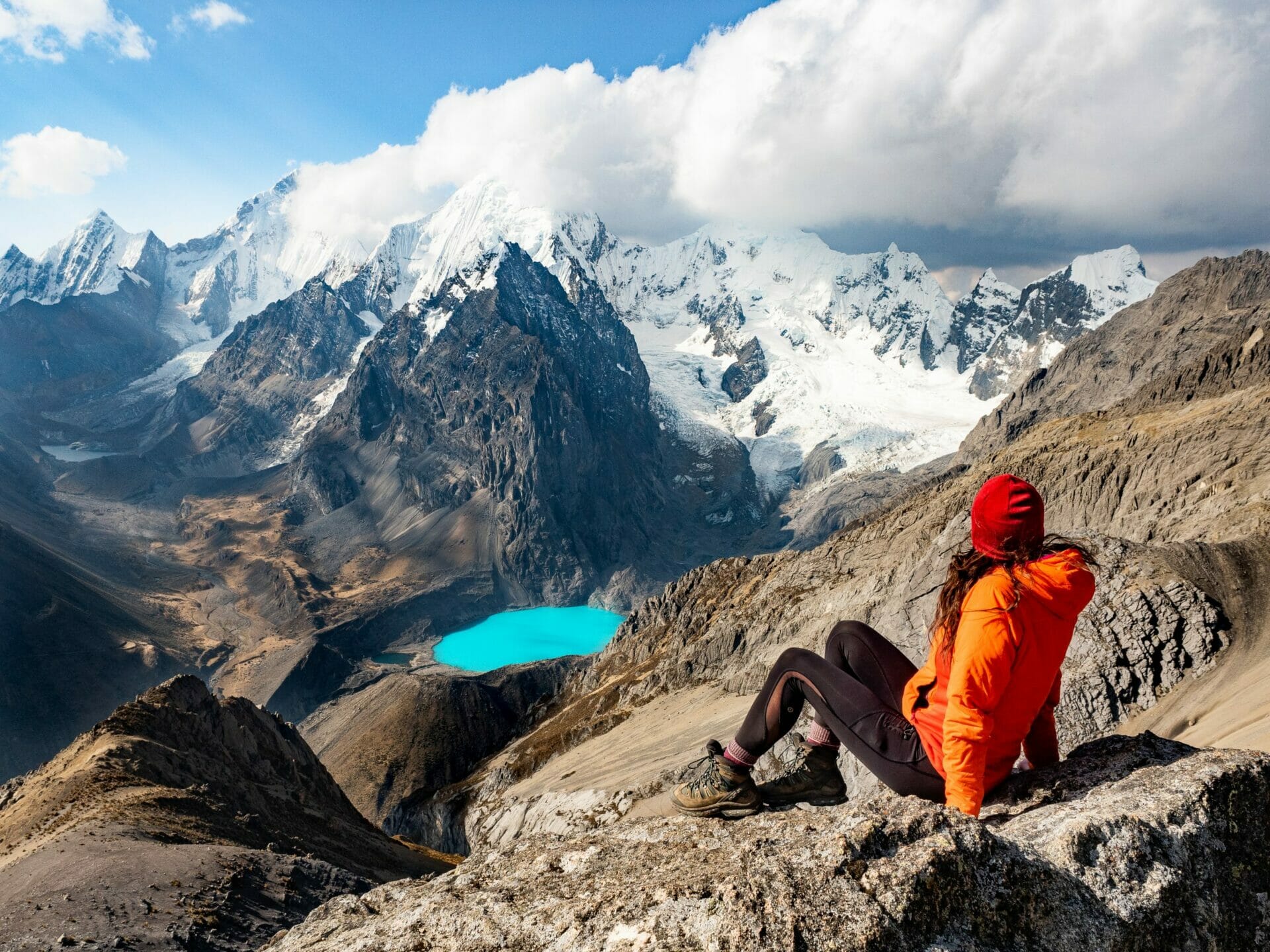
Me, dad and Eileen at Paso Santa Rosa


Paso Santa Rosa

Paso Santa Rosa

The snow this morning certainly threw a spanner in the works— surely it wouldn’t be safe to cross a 5,060m pass in blizzard conditions. Huddled in our tent as all the independent trekkers and the guided group bailed towards the nearby town of Huayllapa, dad, Eileen, and I considered our options carefully. In the end, we set off towards Santa Rosa anyway.

After several hours of what could only be described as wandering aimlessly along a snow-covered moraine in search of the route, the clouds finally let up enough for us to see a faint trail in the distance. The climb to Paso Santa Rosa was seemingly never-ending, but the reward from the top was a surprisingly blue sky and sprawling views, the morning’s snow seeming to disappear as quickly as it had appeared in the first place.

…Only to be replaced by wind, some of the wildest I’ve ever experienced. I was nearly bowled over during the last breathless steps up to the pass, cresting excitedly over the rocks only to be slammed by an enormous wall of wind that threatened to return me all the way back down to the valley floor. Still, I sat directly in the centre of the pass, letting the icy air tear through my jacket and blow my hair into a bird’s nest.

The whip of the wind against my cheeks felt fresh and sharp, but I wanted to savour the feeling of being here. Until dad and Eileen arrived a little later, the only sound was the wild howl of the wind up the pass, an intense noise that completely stripped away all other thoughts— it was impossible to think of anything but this view or to imagine myself anywhere other than on this pass.

Laguna Sarapococha


Laguna Santa Rosa

A rainbow of colours in Quebrada Sarapococha

Even though it’s somewhat famous as the base camp from which Joe Simpson and Simon Yates made a first ascent of Siula Grande’s west face (disaster ensuing), this is still a lesser-explored corner of the Huayhuash Circuit, a remote valley full of ice blue lakes just below the range’s tallest peaks. It’s a fair trek off the main trail (there’s essentially no “trail” to speak of out here), but Quebrada Sarapococha possesses a rugged, dramatic beauty that really is beyond compare— jagged peaks that have claimed many lives contrasting wildly with the dreamy blue of perfectly polished lakes.

There’s a distinct serenity to this place, the silence disturbed only by wind that howls over the mountains, and yet the grey clouds that swirl over the tempestuous summits of Siula Grande and Yerupajá are distinctly forbidding. It’s easy to see what draws climbers to the Cordillera Huayhuash, why young adventurers feel entranced by its dangerous beauty. I feel it myself.

Amidst it all: the deep blue of the lagunas ringed by green algae that almost seems to glow like a neon sign, set against the deep red of the moraines and the brilliant white of the glaciers. Exploring this part of the Cordillera Huayhuash feels like walking through an entire rainbow of colours that shouldn’t exist together, but somehow do. Nature is pure magic.

Camping beneath Rasac

Waking up beneath Rasac

Memorable for a whole host of reasons (not the least of which being a missing stepmum and a nearly hypothermic dad), waking up beneath Rasac on day 8 will still stand out in my mind as the most scenic of all our mornings on the Huayhuash Circuit.

Even with all the drama of the previous day and a lot of uncertainty still hanging overhead, poking my nose out of the tent to see blue skies and bright sun flaring across the glacier seemed like as clear an indication as any that everything was going to work out just fine. And it did.

Condors at Cerro Huacrish


Cairns at Cerro Huacrish

Golden morning at Cerro Huacrish

We fell behind schedule towards the end of the trip, to the point where we seriously had to consider taking a shortcut in order to meet our shuttle on time. With the 3pm deadline looming large overhead, dad and Eileen were forced to change their plans and hike out to Llamac, a small town where most people start and end the trek, but I just couldn’t bear the idea of missing a single mountain pass (and certainly not two). I would hike out over Sambuya and Rondoy Puntas alone.

Still, I had been feeling a lot of uncertainty about navigating this final stretch of trail, a variation from the traditional route. Nestled in my sleeping bag the night before, I just kept thinking what if I can’t find the way, what if I don’t make it in time, what if I end up incredibly lost and I can’t get back on route?!

But that morning, I set off under clear skies, a woman on a mission. With some difficulty, I found the trail from the pass and followed it up towards the ridgeline, confidence building with each step. And when I crested over the hill and looked back at camp, out at the Cordillera Huayhuash glowing in the early morning light, up at the enormous condors circling overhead, all of those worries suddenly melted away and I felt on top of the world. Strong and capable and sure that I’d be able to get wherever I needed to go. Ready to embrace the day and savour the challenge.

Ending the Huayhuash Circuit back in Quartelhuain

Closing the circuit

Arriving at the campsite where I first put my pack on and set off 10 whole days ago brought such an enormous sense of closure to this trip. I chucked my pack to the ground, pulled off my boots for the last time, and then sat admiring my grimy hands and dirt-streaked legs, evidence of the many kilometres walked and all the wild adventures had since I was last here. I felt changed in a million small ways.

Read more about the Huayhuash Circuit

THE ULTIMATE GUIDE TO INDEPENDENT & SOLO HIKING THE HUAYHUASH CIRCUIT IN PERU

SOLO HUAYHUASH CIRCUIT PACKING LIST: WHAT TO PACK FOR 10 DAYS WITHOUT A GUIDE

HUAYHUASH CIRCUIT (DAY 1): QUARTELHUAIN TO LAGUNA MITUCOCHA

HUAYHUASH CIRCUIT (DAY 2): LAGUNA MITUCOCHA TO LAGUNA CARHUACOCHA

HUAYHUASH CIRCUIT (DAY 3): LAGUNA CARHUACOCHA TO HUAYHUASH

HUAYHUASH CIRCUIT (DAY 4): HUAYHUASH TO VICONGA

HUAYHUASH CIRCUIT (DAY 5): VICONGA TO CUYOC & PASO SAN ANTONIO

HUAYHUASH CIRCUIT (DAY 6): CUYOC & PASO SAN ANTONIO TO LAGUNA JURAUCOCHA

HUAYHUASH CIRCUIT (DAY 7): LAGUNA JURAUCOCHA TO RASAC VIA LAGUNA SANTA ROSA & PASO ROSARIO

HUAYHUASH CIRCUIT (DAY 8): RASAC TO HUAYLLAPA

HUAYHUASH CIRCUIT (DAY 9): HUAYLLAPA TO YAUCHA PUNTA

HUAYHUASH CIRCUIT (DAY 10): YAUCHA PUNTA TO QUARTELHUAIN VIA RONDOY PUNTA

TAGS:trail guides
2 Comments
Share
brooke beyond

Hey, I'm Brooke and I'm obsessed with getting off the beaten path, exploring backcountry gems & travelling beyond the ordinary! I left Australia 5 years ago after finishing a PhD in Biomechanics & have been travelling the world full-time ever since (joined by my life/climbing partner, James). Whether it’s road-tripping through Mexico, climbing alpine peaks in the Andes, scuba diving in the Red Sea, or tackling epic via ferrata in the Dolomites, I hope this blog will inspire your future adventures & help you find wonder in every corner of the globe. xx bb

Leave a Comment Cancel Comment

The Comments

  • Joe Schaeffer
    28 October 2021

    Thanks so much for these awesome posts and pictures. I think your post answered my question, but I’ll ask anyway. Was the Cordillera Huayhuash that much more spectacular than Ausungate? (Looks like yes!) I wanted to follow up Salkantay with another trek, but was trying to weigh whether it was worth the extra time and effort to go all the way to Huaraz, or if my experience on the Ausangate would be equally fulfilling.
    Thanks again, and keep posting!

    Reply
    • brooke brisbine
      Joe Schaeffer
      29 October 2021

      Hi Joe, thanks for reading!

      It’s hard to say that the Huayhuash is “more spectacular” than Ausangate, which is also an incredible trekking route with heaps of amazing scenery, but I will say that the Huayhuash is twice as long, which means twice the views and half the people. If time allows, I don’t think you’ll be disappointed, even with the extra effort of getting from Cusco back to Lima and up to Huaraz!

      Happy trails,
      Brooke

      Reply

You May Also Like

31 August 2020

A delicious DIY street food tour of Cartagena for under $10

26 October 2019

Travelling with Peru Hop vs public buses: An honest comparison

11 February 2022

Vanlife diaries #48: Mazamitla, Jocotopec & Ajijic, Jalisco Mexico

hi, I’m brooke!

I'm obsessed with getting off the beaten path, exploring backcountry gems & travelling beyond the ordinary! I left Australia 5 years ago after finishing a PhD in Biomechanics & have been travelling the world full-time ever since (now joined by my life/climbing partner, James). I hope this blog will inspire your future adventures & help you find wonder in every corner of the globe. xx bb

read my story
currently exploring

currently exploring

mexico

read our gear guides

🥾 hiking boots

🎒 hiking backpacks

🌨️ cold-weather layers

⛺️ backpacking & alpine tents

🛌 sleeping bag & pads

🍪 backcountry food

📸 travel camera gear

✈️ travel clothing

trail guides

summit guides

itineraries

outdoor gear

GPS maps

recent posts

  • Climbing Iztaccíhuatl volcano

    2-week Mexico volcanoes itinerary: climbing Pico de Orizaba, Izta, Malinche & Toluca

    3 June 2025
  • Mexico City: the perfect 5-day itinerary for CDMX

    31 May 2025
  • Climbing Iztaccíhuatl volcano

    Driving in Mexico: essential road trip guide for foreigners

    28 May 2025
  • 10-day Rwanda road trip itinerary: gorillas, volcanoes & Lake Kivu

    25 May 2025
  • 2-week Patagonia itinerary: best of Torres del Paine & Los Glaciares/El Chaltén

    22 May 2025

@brookebeyond_
brooke ✨travel & mountain gal

@brookebeyond_

  • magical moments in the swiss alps 🐄🇨🇭🧀🫐🌺
.
.
.
.
.
#swissalps #switzerland #matterhorn #zermatt #oeschinensee #lucerne #jungfraujoch #grindelwald #swisssummer
  • NEW CUSTOM GPS MAPS!!

✨ shop.brookebeyond.com ✨

Before every single backpacking trip, hut-to-hut & alpine expedition, I spend dozens of hours on @caltopo building a GPS track to help me navigate along the route confidently, especially when venturing off the standard trail (which I nearly always do) 🗺️

And after MANY requests to share my custom routes, I now have 8 super detailed JSON/GPX files that you can use to plan your own epic adventure off the beaten path— navigating right off your smartphone!!!

Available maps:
🇮🇹 Alta Via 2
🇮🇹 Alta Via 4
🇫🇷 Mont Blanc Summit
🇵🇪 Huayhuash Circuit
🇦🇷 Aconcagua Summit
🇺🇸 Teton Crest Trail
🇨🇱 O-Circuit
🇦🇷 Fitz Roy Loop
+ more coming soon!

These maps include detailed route beta with hundreds of waypoints, essential trail stats, alternatives & bailouts, side-trips & summits, all based on my adventurous modifications to these amazing routes! 

They’ve been heavily tested by friends & readers, and I’m confident you won’t find another resource like them 🗺️

✨ shop.brookebeyond.com ✨

ps. If you’ve bought one of my maps this summer (AV2 + AV4 have been SO popular!), I’d love to hear from you!!
  • We took our own engagement photos in the Swiss Alps this summer and here’s how it went 👉🏼

(#8 might just be my personal fave 😂)

ALSO this post is for anyone who’s gotten the (woefully mistaken) impression that I am “naturally photogenic”
  • absolutely one of the most amazing little hikes we did in Switzerlnad this summer (& the competition was stiff) 🤩🏔️🌞🌸

📍Saxer Lücke

GETTING THERE: catch the Frümsen gondola to Staubernkanzel

HIKE: 1hr (2.5km, 250m gain) to this amazing viewpoint

WHEN TO GO: the best lighting is in the afternoon, these photos were taken around 4pm and it just kept getting better!
.
.
.
.
.
#swissalps #switzerland #saxerlücke #swisssummer #alpstein
  • the BEST easy hike in Zermatt 🏔️🥾✨

For spectacular views of the Matterhorn, the enormous Monte Rosa massif, and the Gorner Glacier (as well as 29 peaks over 4,000m!), there’s no better EASY hike than Riffelberg to Gornergrat, accessible via the Gornergrat Railway in Zermatt. 

The hike only takes about 2hrs at a leisurely pace (I did it 7 weeks after knee surgery!), so it’s suitable for families and non-hikers with even a basic level of fitness 🏃🏻‍♀️

🇨🇭 START FROM ZERMATT
- purchase tickets (day-of is fine) from Gornergrat Railway, right across from Zermatt train station

🚞 GORNERGRAT RAILWAY
- tickets from Zermatt to Riffelberg cost 42CHF ($50USD)— there’s no discount for return, so keep it flexible by purchasing one-way
- the train takes the about 25min, sit on the right side for best views!
- when you finish the hike at Gornergrat, buy a one-way ticket back to Zermatt for 66CHF ($80USD)
- save 50% on tickets with the Swiss Half Fare Card— the pass costs 120CHF ($150USD) and lasts for a whole month, it’s almost always worth it!) 

🥾 HIKE DETAILS: RIFFELSEE TO GORNERGRAT
- the route is 5km with 560m elevation gain (entirely uphill)
- the best views of the Matterhorn are around Riffelsee, where several small lakes offer perfect reflections
- near Rotenboden (the train station in between Riffelberg & Gornergrat), there are excellent rocky viewpoints of both Matterhorn and Monta Rosa— it’s easy to find quiet views if you hike around a bit!
- as you get closer to Gornergrat, Monte Rosa and the Gorner Glacier are right in your face
- almost everyone does this hike in reverse (Gornergrat to Riffelberg), I just personally hate hiking downhill— but you can swap if you’d rather descend the entire way!
  • 2 months after knee surgery and barely a week after I stopped walking with a knee brace and cane, I was honestly so proud to be able to do this (objectively very easy) 5km hike with 250m gain— it may not seem like much, but for me, this was a HUGE step forward 🥹

📍 Saxer Lücke, Switzerland 

it’s been an extremely challenging recovery, both physically and mentally… but the milestone moments always fill me with hope that things are indeed getting better ❤️‍🩹

special shoutout to my fiancé/hiking partner/personal cheering squad @slatojc for slowing down with me on the trail and always offering a hand down slippery rocks before I even have to ask
  • it’s another “if it wasn’t so stupid beautiful, I’d never set foot in this country again because it’s bleeding me dry” kinda summer 🇨🇭🌸☀️🏔️🦋✨

(hands up if you feel personally victimised by Swiss prices but you can’t stay away because MOUNTAINS 😭😭)
  • magical summer sunsets in Switzerland ✨
.
.
.
.
#swissalps #stoosridge #swisssummer #sunset
  • BEST EASY HIKES IN SWITZERLAND 🇨🇭❤️‍🩹

just 2 months after knee surgery, I found myself travelling through Switzerland— in search of easy hikes that were actually accessible post-op 🩼 

luckily, there’s hardly a better place in the world for easy hiking than the Swiss Alps!!

so whether you’re recovering from an injury, hiking with older parents/young children, or just a non-hiker who loves an epic view, this short list of HIGH VALUE viewpoints & hikes offer the most spectacular mountain scenery with minimal challenge

💸 BUDGET TIP: buy the Swiss Half Fare Card to save 50% all these gondolas and trains, which can seriously add up!!

- Stoos Ridge: take the Stoosbahn to the little village of Stoos + walk about 15min to the chairlift that can take you all the way up to Fronalpstock— you can walk as little or as much as you want up here, the views are amazing right away
- Riffelsee: take the Gornergrat Railway from Zermatt to Riffelsee + hike 20min to the 2 beautiful alpine lakes (then either hike 1hr up to Gornergrat or catch the train)
- Saxer Lücke: catch a gondola + hike 1hr (2.5km, 250m gain) to this amazing viewpoint— hardest on this list and not suitable for those with extremely limited mobility 
- Kleine Scheidegg: take the train or the gondola from Grindelwald + hike about 20min uphill to the lake
- Jungfraujoch: from Kleine Scheidegg, take the gondola to Jungfraujoch + walk around the viewing platforms
- Trockener Steg: take the gondola from Zermatt + walk 10min from the top of the cable car to the lake for incredible Matterhorn views
- Oeschinensee: 20min walk from the top of the Kandersteg cable car to the lake (bus also available), then you can walk as little or as much as you want around the lake or on the famous Panorama Trail
.
.
.
.
.
#easyhikes #swissalps #matterhorn #jungfraujoch #oeschinensee #stoos #switzerland
follow @brookebeyond_

travel beyond the ordinary

Explore my travel guides, custom itineraries & blog posts with an interactive world map ✨

all destinations

  • magical moments in the swiss alps 🐄🇨🇭🧀🫐🌺
.
.
.
.
.
#swissalps #switzerland #matterhorn #zermatt #oeschinensee #lucerne #jungfraujoch #grindelwald #swisssummer
  • NEW CUSTOM GPS MAPS!!

✨ shop.brookebeyond.com ✨

Before every single backpacking trip, hut-to-hut & alpine expedition, I spend dozens of hours on @caltopo building a GPS track to help me navigate along the route confidently, especially when venturing off the standard trail (which I nearly always do) 🗺️

And after MANY requests to share my custom routes, I now have 8 super detailed JSON/GPX files that you can use to plan your own epic adventure off the beaten path— navigating right off your smartphone!!!

Available maps:
🇮🇹 Alta Via 2
🇮🇹 Alta Via 4
🇫🇷 Mont Blanc Summit
🇵🇪 Huayhuash Circuit
🇦🇷 Aconcagua Summit
🇺🇸 Teton Crest Trail
🇨🇱 O-Circuit
🇦🇷 Fitz Roy Loop
+ more coming soon!

These maps include detailed route beta with hundreds of waypoints, essential trail stats, alternatives & bailouts, side-trips & summits, all based on my adventurous modifications to these amazing routes! 

They’ve been heavily tested by friends & readers, and I’m confident you won’t find another resource like them 🗺️

✨ shop.brookebeyond.com ✨

ps. If you’ve bought one of my maps this summer (AV2 + AV4 have been SO popular!), I’d love to hear from you!!
  • We took our own engagement photos in the Swiss Alps this summer and here’s how it went 👉🏼

(#8 might just be my personal fave 😂)

ALSO this post is for anyone who’s gotten the (woefully mistaken) impression that I am “naturally photogenic”
  • absolutely one of the most amazing little hikes we did in Switzerlnad this summer (& the competition was stiff) 🤩🏔️🌞🌸

📍Saxer Lücke

GETTING THERE: catch the Frümsen gondola to Staubernkanzel

HIKE: 1hr (2.5km, 250m gain) to this amazing viewpoint

WHEN TO GO: the best lighting is in the afternoon, these photos were taken around 4pm and it just kept getting better!
.
.
.
.
.
#swissalps #switzerland #saxerlücke #swisssummer #alpstein
  • the BEST easy hike in Zermatt 🏔️🥾✨

For spectacular views of the Matterhorn, the enormous Monte Rosa massif, and the Gorner Glacier (as well as 29 peaks over 4,000m!), there’s no better EASY hike than Riffelberg to Gornergrat, accessible via the Gornergrat Railway in Zermatt. 

The hike only takes about 2hrs at a leisurely pace (I did it 7 weeks after knee surgery!), so it’s suitable for families and non-hikers with even a basic level of fitness 🏃🏻‍♀️

🇨🇭 START FROM ZERMATT
- purchase tickets (day-of is fine) from Gornergrat Railway, right across from Zermatt train station

🚞 GORNERGRAT RAILWAY
- tickets from Zermatt to Riffelberg cost 42CHF ($50USD)— there’s no discount for return, so keep it flexible by purchasing one-way
- the train takes the about 25min, sit on the right side for best views!
- when you finish the hike at Gornergrat, buy a one-way ticket back to Zermatt for 66CHF ($80USD)
- save 50% on tickets with the Swiss Half Fare Card— the pass costs 120CHF ($150USD) and lasts for a whole month, it’s almost always worth it!) 

🥾 HIKE DETAILS: RIFFELSEE TO GORNERGRAT
- the route is 5km with 560m elevation gain (entirely uphill)
- the best views of the Matterhorn are around Riffelsee, where several small lakes offer perfect reflections
- near Rotenboden (the train station in between Riffelberg & Gornergrat), there are excellent rocky viewpoints of both Matterhorn and Monta Rosa— it’s easy to find quiet views if you hike around a bit!
- as you get closer to Gornergrat, Monte Rosa and the Gorner Glacier are right in your face
- almost everyone does this hike in reverse (Gornergrat to Riffelberg), I just personally hate hiking downhill— but you can swap if you’d rather descend the entire way!
magical moments in the swiss alps 🐄🇨🇭🧀🫐🌺
.
.
.
.
.
#swissalps #switzerland #matterhorn #zermatt #oeschinensee #lucerne #jungfraujoch #grindelwald #swisssummer
magical moments in the swiss alps 🐄🇨🇭🧀🫐🌺
.
.
.
.
.
#swissalps #switzerland #matterhorn #zermatt #oeschinensee #lucerne #jungfraujoch #grindelwald #swisssummer
magical moments in the swiss alps 🐄🇨🇭🧀🫐🌺
.
.
.
.
.
#swissalps #switzerland #matterhorn #zermatt #oeschinensee #lucerne #jungfraujoch #grindelwald #swisssummer
magical moments in the swiss alps 🐄🇨🇭🧀🫐🌺
.
.
.
.
.
#swissalps #switzerland #matterhorn #zermatt #oeschinensee #lucerne #jungfraujoch #grindelwald #swisssummer
magical moments in the swiss alps 🐄🇨🇭🧀🫐🌺
.
.
.
.
.
#swissalps #switzerland #matterhorn #zermatt #oeschinensee #lucerne #jungfraujoch #grindelwald #swisssummer
magical moments in the swiss alps 🐄🇨🇭🧀🫐🌺
.
.
.
.
.
#swissalps #switzerland #matterhorn #zermatt #oeschinensee #lucerne #jungfraujoch #grindelwald #swisssummer
magical moments in the swiss alps 🐄🇨🇭🧀🫐🌺
.
.
.
.
.
#swissalps #switzerland #matterhorn #zermatt #oeschinensee #lucerne #jungfraujoch #grindelwald #swisssummer
magical moments in the swiss alps 🐄🇨🇭🧀🫐🌺
.
.
.
.
.
#swissalps #switzerland #matterhorn #zermatt #oeschinensee #lucerne #jungfraujoch #grindelwald #swisssummer
magical moments in the swiss alps 🐄🇨🇭🧀🫐🌺
.
.
.
.
.
#swissalps #switzerland #matterhorn #zermatt #oeschinensee #lucerne #jungfraujoch #grindelwald #swisssummer
magical moments in the swiss alps 🐄🇨🇭🧀🫐🌺
.
.
.
.
.
#swissalps #switzerland #matterhorn #zermatt #oeschinensee #lucerne #jungfraujoch #grindelwald #swisssummer
magical moments in the swiss alps 🐄🇨🇭🧀🫐🌺
.
.
.
.
.
#swissalps #switzerland #matterhorn #zermatt #oeschinensee #lucerne #jungfraujoch #grindelwald #swisssummer
magical moments in the swiss alps 🐄🇨🇭🧀🫐🌺
.
.
.
.
.
#swissalps #switzerland #matterhorn #zermatt #oeschinensee #lucerne #jungfraujoch #grindelwald #swisssummer
magical moments in the swiss alps 🐄🇨🇭🧀🫐🌺
.
.
.
.
.
#swissalps #switzerland #matterhorn #zermatt #oeschinensee #lucerne #jungfraujoch #grindelwald #swisssummer
@brookebeyond_
@brookebeyond_
•
Follow
magical moments in the swiss alps 🐄🇨🇭🧀🫐🌺 . . . . . #swissalps #switzerland #matterhorn #zermatt #oeschinensee #lucerne #jungfraujoch #grindelwald #swisssummer
1 day ago
View on Instagram |
1/5
NEW CUSTOM GPS MAPS!!

✨ shop.brookebeyond.com ✨

Before every single backpacking trip, hut-to-hut & alpine expedition, I spend dozens of hours on @caltopo building a GPS track to help me navigate along the route confidently, especially when venturing off the standard trail (which I nearly always do) 🗺️

And after MANY requests to share my custom routes, I now have 8 super detailed JSON/GPX files that you can use to plan your own epic adventure off the beaten path— navigating right off your smartphone!!!

Available maps:
🇮🇹 Alta Via 2
🇮🇹 Alta Via 4
🇫🇷 Mont Blanc Summit
🇵🇪 Huayhuash Circuit
🇦🇷 Aconcagua Summit
🇺🇸 Teton Crest Trail
🇨🇱 O-Circuit
🇦🇷 Fitz Roy Loop
+ more coming soon!

These maps include detailed route beta with hundreds of waypoints, essential trail stats, alternatives & bailouts, side-trips & summits, all based on my adventurous modifications to these amazing routes! 

They’ve been heavily tested by friends & readers, and I’m confident you won’t find another resource like them 🗺️

✨ shop.brookebeyond.com ✨

ps. If you’ve bought one of my maps this summer (AV2 + AV4 have been SO popular!), I’d love to hear from you!!
@brookebeyond_
@brookebeyond_
•
Follow
NEW CUSTOM GPS MAPS!! ✨ shop.brookebeyond.com ✨ Before every single backpacking trip, hut-to-hut & alpine expedition, I spend dozens of hours on @caltopo building a GPS track to help me navigate along the route confidently, especially when venturing off the standard trail (which I nearly always do) 🗺️ And after MANY requests to share my custom routes, I now have 8 super detailed JSON/GPX files that you can use to plan your own epic adventure off the beaten path— navigating right off your smartphone!!! Available maps: 🇮🇹 Alta Via 2 🇮🇹 Alta Via 4 🇫🇷 Mont Blanc Summit 🇵🇪 Huayhuash Circuit 🇦🇷 Aconcagua Summit 🇺🇸 Teton Crest Trail 🇨🇱 O-Circuit 🇦🇷 Fitz Roy Loop + more coming soon! These maps include detailed route beta with hundreds of waypoints, essential trail stats, alternatives & bailouts, side-trips & summits, all based on my adventurous modifications to these amazing routes! They’ve been heavily tested by friends & readers, and I’m confident you won’t find another resource like them 🗺️ ✨ shop.brookebeyond.com ✨ ps. If you’ve bought one of my maps this summer (AV2 + AV4 have been SO popular!), I’d love to hear from you!!
3 days ago
View on Instagram |
2/5
We took our own engagement photos in the Swiss Alps this summer and here’s how it went 👉🏼

(#8 might just be my personal fave 😂)

ALSO this post is for anyone who’s gotten the (woefully mistaken) impression that I am “naturally photogenic”
We took our own engagement photos in the Swiss Alps this summer and here’s how it went 👉🏼

(#8 might just be my personal fave 😂)

ALSO this post is for anyone who’s gotten the (woefully mistaken) impression that I am “naturally photogenic”
We took our own engagement photos in the Swiss Alps this summer and here’s how it went 👉🏼

(#8 might just be my personal fave 😂)

ALSO this post is for anyone who’s gotten the (woefully mistaken) impression that I am “naturally photogenic”
We took our own engagement photos in the Swiss Alps this summer and here’s how it went 👉🏼

(#8 might just be my personal fave 😂)

ALSO this post is for anyone who’s gotten the (woefully mistaken) impression that I am “naturally photogenic”
We took our own engagement photos in the Swiss Alps this summer and here’s how it went 👉🏼

(#8 might just be my personal fave 😂)

ALSO this post is for anyone who’s gotten the (woefully mistaken) impression that I am “naturally photogenic”
We took our own engagement photos in the Swiss Alps this summer and here’s how it went 👉🏼

(#8 might just be my personal fave 😂)

ALSO this post is for anyone who’s gotten the (woefully mistaken) impression that I am “naturally photogenic”
We took our own engagement photos in the Swiss Alps this summer and here’s how it went 👉🏼

(#8 might just be my personal fave 😂)

ALSO this post is for anyone who’s gotten the (woefully mistaken) impression that I am “naturally photogenic”
We took our own engagement photos in the Swiss Alps this summer and here’s how it went 👉🏼

(#8 might just be my personal fave 😂)

ALSO this post is for anyone who’s gotten the (woefully mistaken) impression that I am “naturally photogenic”
We took our own engagement photos in the Swiss Alps this summer and here’s how it went 👉🏼

(#8 might just be my personal fave 😂)

ALSO this post is for anyone who’s gotten the (woefully mistaken) impression that I am “naturally photogenic”
We took our own engagement photos in the Swiss Alps this summer and here’s how it went 👉🏼

(#8 might just be my personal fave 😂)

ALSO this post is for anyone who’s gotten the (woefully mistaken) impression that I am “naturally photogenic”
@brookebeyond_
@brookebeyond_
•
Follow
We took our own engagement photos in the Swiss Alps this summer and here’s how it went 👉🏼 (#8 might just be my personal fave 😂) ALSO this post is for anyone who’s gotten the (woefully mistaken) impression that I am “naturally photogenic”
6 days ago
View on Instagram |
3/5
@brookebeyond_
@brookebeyond_
•
Follow
absolutely one of the most amazing little hikes we did in Switzerlnad this summer (& the competition was stiff) 🤩🏔️🌞🌸 📍Saxer Lücke GETTING THERE: catch the Frümsen gondola to Staubernkanzel HIKE: 1hr (2.5km, 250m gain) to this amazing viewpoint WHEN TO GO: the best lighting is in the afternoon, these photos were taken around 4pm and it just kept getting better! . . . . . #swissalps #switzerland #saxerlücke #swisssummer #alpstein
7 days ago
View on Instagram |
4/5
the BEST easy hike in Zermatt 🏔️🥾✨

For spectacular views of the Matterhorn, the enormous Monte Rosa massif, and the Gorner Glacier (as well as 29 peaks over 4,000m!), there’s no better EASY hike than Riffelberg to Gornergrat, accessible via the Gornergrat Railway in Zermatt. 

The hike only takes about 2hrs at a leisurely pace (I did it 7 weeks after knee surgery!), so it’s suitable for families and non-hikers with even a basic level of fitness 🏃🏻‍♀️

🇨🇭 START FROM ZERMATT
- purchase tickets (day-of is fine) from Gornergrat Railway, right across from Zermatt train station

🚞 GORNERGRAT RAILWAY
- tickets from Zermatt to Riffelberg cost 42CHF ($50USD)— there’s no discount for return, so keep it flexible by purchasing one-way
- the train takes the about 25min, sit on the right side for best views!
- when you finish the hike at Gornergrat, buy a one-way ticket back to Zermatt for 66CHF ($80USD)
- save 50% on tickets with the Swiss Half Fare Card— the pass costs 120CHF ($150USD) and lasts for a whole month, it’s almost always worth it!) 

🥾 HIKE DETAILS: RIFFELSEE TO GORNERGRAT
- the route is 5km with 560m elevation gain (entirely uphill)
- the best views of the Matterhorn are around Riffelsee, where several small lakes offer perfect reflections
- near Rotenboden (the train station in between Riffelberg & Gornergrat), there are excellent rocky viewpoints of both Matterhorn and Monta Rosa— it’s easy to find quiet views if you hike around a bit!
- as you get closer to Gornergrat, Monte Rosa and the Gorner Glacier are right in your face
- almost everyone does this hike in reverse (Gornergrat to Riffelberg), I just personally hate hiking downhill— but you can swap if you’d rather descend the entire way!
@brookebeyond_
@brookebeyond_
•
Follow
the BEST easy hike in Zermatt 🏔️🥾✨ For spectacular views of the Matterhorn, the enormous Monte Rosa massif, and the Gorner Glacier (as well as 29 peaks over 4,000m!), there’s no better EASY hike than Riffelberg to Gornergrat, accessible via the Gornergrat Railway in Zermatt. The hike only takes about 2hrs at a leisurely pace (I did it 7 weeks after knee surgery!), so it’s suitable for families and non-hikers with even a basic level of fitness 🏃🏻‍♀️ 🇨🇭 START FROM ZERMATT - purchase tickets (day-of is fine) from Gornergrat Railway, right across from Zermatt train station 🚞 GORNERGRAT RAILWAY - tickets from Zermatt to Riffelberg cost 42CHF ($50USD)— there’s no discount for return, so keep it flexible by purchasing one-way - the train takes the about 25min, sit on the right side for best views! - when you finish the hike at Gornergrat, buy a one-way ticket back to Zermatt for 66CHF ($80USD) - save 50% on tickets with the Swiss Half Fare Card— the pass costs 120CHF ($150USD) and lasts for a whole month, it’s almost always worth it!) 🥾 HIKE DETAILS: RIFFELSEE TO GORNERGRAT - the route is 5km with 560m elevation gain (entirely uphill) - the best views of the Matterhorn are around Riffelsee, where several small lakes offer perfect reflections - near Rotenboden (the train station in between Riffelberg & Gornergrat), there are excellent rocky viewpoints of both Matterhorn and Monta Rosa— it’s easy to find quiet views if you hike around a bit! - as you get closer to Gornergrat, Monte Rosa and the Gorner Glacier are right in your face - almost everyone does this hike in reverse (Gornergrat to Riffelberg), I just personally hate hiking downhill— but you can swap if you’d rather descend the entire way!
2 weeks ago
View on Instagram |
5/5

  • start here
  • about
  • group trips
  • destinations
  • hiking guides
  • outdoor gear
  • custom GPS maps
  • privacy
  • contact

COPYRIGHT © 2025 BROOKE BEYOND. TRAVEL BEYOND THE ORDINARY. Site Powered by Pix & Hue.


Loading Comments...