
Last Updated on 12 April 2026
Among the most popular photo vantage points in the entire North Cascades, Sahale Glacier Camp is simply breathtaking. After hiking an incredibly gentle trail to Cascade Pass and then continuing through the heather to ascend a much steeper, rockier route to Sahale Arm, the entirety of the range seems to stretch before you, Doubtful Lake acting as a sparkling sapphire centrepiece to the dark granite and bright snowy slopes. One look and I was hooked— I HAD to get here.
Unsurprisingly, permits for Sahale Arm are now insanely hard to come by, so when dad and Eileen managed to secure spots at not only Sahale Arm but also Boston Basin this summer, it didn’t take much convincing for me to drop everything and hop onto what would be a spectacular 5-day adventure (and my first real foray) into North Cascades National Park. Tossing in a few challenging summits and a new climbing partner, the week delivered even more than promised.

Day 1: Cascade River Road to Cascade Pass TH
Cruising along Cascade River Road towards the Cascade Pass TH on Wednesday afternoon, we were stopped around mile 18 due to road damage from a recent storm— we had expected this, but it didn’t make the 5.5mi hike on mixed gravel and pavement any more appealing.
There was a massive string of cars already parked along the shoulder, but we slotted ourselves in right at the roadblock and were joined by Kellie moments after we pulled packs from the car.


The next 2hrs passed as pleasantly as road hiking can ever pass, all exchanging excited chatter as we all looked forward to the week’s adventure.
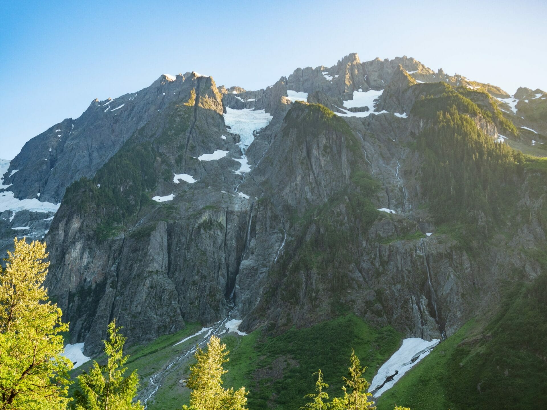
By the time we did reach the Cascade Pass Trailhead that evening, a spectacular destination in its own right with the glaciated Johannesburg lurking overhead, we pitched tents directly in the parking lot and launched into a luxurious dinner on the picnic table— the last seat we’d be seeing for a while.

Day 2: Cascade Pass TH to Sahale Arm
The following day, we woke to partial sun and eagerly hit the trail up towards Cascade Pass, one of the most popular day hiking destinations in the entire state.
On a Thursday morning with the road closes 5.5mi from the trailhead, though, we had the path to ourselves, save for one other group of backpackers who’d also camped in the parking lot.
Beautifully graded and impossibly gentle, we arrived to Cascade Pass 2hrs later without having hardly broken a sweat, ready to enjoy a prolonged lunch break in the sun and sweeping view of the Cascades. It was easily an hour before we saddled back up and continued the ascent to Sahale Arm, our camp for the night.


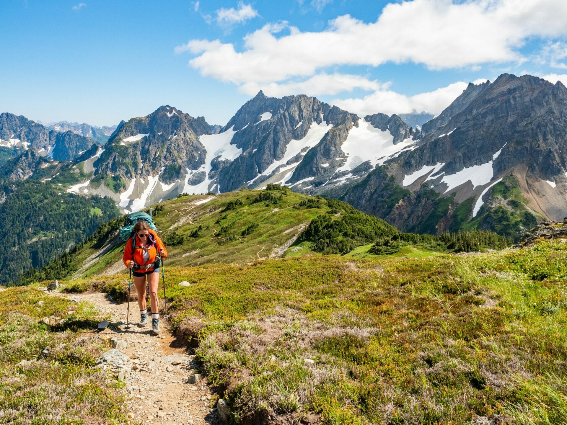
Treating the hike as if we had all the time in the world (which, in truth, we did), the group set a leisurely pace up the trail towards Sahale— allowing ample time for me to run around photographing the swathe of colourful wildflowers and all the sparkling alpine lakes coming into view.
Cascade Pass is certainly beautiful, but it just can’t compare to the views afforded another hour up the trail towards Sahale Arm, where the mountains loom taller, the marmots run wilder, and the wildflowers are an explosion of texture in the foreground of every shot.
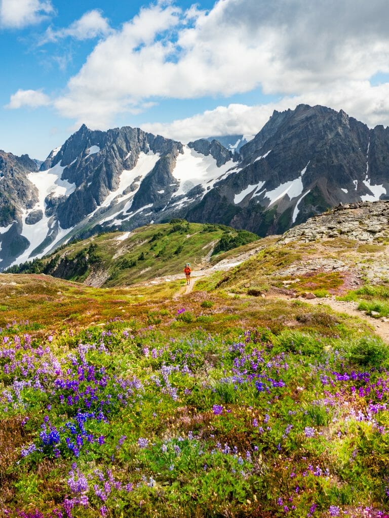


Something about the narrow boot path winding and weaving through a sea of rough heather and scattered granite made the entire scene feel like a painting, distinctly set in the North Cascades. For my first true foray into the National park, we couldn’t have chosen a better spot.


No sooner had we arrived to our camp at the base of the Sahale Glacier, one of the most coveted sites in the North Cascade (with a permitting system to match), than an enormous fog bank rolled in and blanketed our beautiful view in white.
The only thing that spared us great disappointment was the fact that we’d have this site a second night and therefore that there would be innumerable opportunities to photograph the dramatic view.


An abundance of very friendly mountain goats also provided an excellent consolation, and I spent the better part of an hour photographing them in various locations around camp before I learned that all I really needed to do to secure a quality goat photo was pee near the tent and wait for them to come eat it up (strange, but true).
We fell asleep to wicked wind and the sound of goats munching nearby, which incidentally is pretty much how we woke up the following morning.

Day 3: Sahale Arm to Buckner Mountain & return
Poised for a lengthy day, we set out around 7.30am to tackle our first climbing objective of the trip, Mt Buckner.
Despite appearing only a few miles beyond our camp at Sahale Arm, dad estimated that we’d need 12hrs to summit via the SW face and return to the tents— a timeframe that seemed overly conservative at the time, but ended up being several hours short of the truly massive day we had in front of us.


We began the journey by descending on mixed snow and dirt outcroppings, soon reaching a mess of rock that required methodical down climbing, and finally arriving at a steep snow chute where we donned crampons and palmed ice axes in anticipation of a very hairy descent.


After carefully finding our way into the side of an ice moat about an hour after leaving camp, we just as carefully ascended a vertical edge onto the frozen snow finger above and contoured across a gradual slope above the basin.
Still unroped and far from high alert, I took my first slide of the day mere seconds after dad called out that this would be an excellent place to fall since the runout made serious injury very unlikely— the timing was so uncanny that Eileen genuinely thought I’d taken the fall on purpose, just to practice.
Thankfully, the slide ended up being a bit of a shortcut towards our route and I didn’t bring anyone down with me (being unroped), but it was also a very valuable learning experience— the thick and very wet gloves I was wearing could hardly get purchase on my axe and it took me far longer to arrest than I would have liked. As soon as I was back on two feet, I changed into different gloves and vowed to keep my guard up.


Over the next several hours, we ascended increasingly steep snow slopes in an effort to reach the 45 degree wall beneath Buckner and scramble up to the summit.
It was incredibly tedious, the peak barely appearing any closer with each passing hour, but it was also incredibly exhilarating to meet the challenges laid before me, gaining confidence with every step. When dad called down to me that this was “no mistakes territory”, I felt fully capable of executing a considered, methodical route up the peak.

After taking off crampons and ascending a treacherous slope of loose dirt and scree, we finally reached the summit block and made quick work of the final ascent all the way to the top.
Climbing Buckner was no insignificant feat (a full 7hrs had elapsed since we left camp), but all were in high spirits as we enjoyed a boots-off break and an extended lunch on the summit.


Those high spirits were quickly squashed by our return journey. Down climbing the summit block was no particular challenge, but descending over the loose dirt and scree was positively miserable— and it only got worse from here.
The exciting unroped climb we’d enjoyed up Buckner’s steep snow chute under pleasant morning conditions was a distant memory as we roped together and descended 1500ft of melting snow, every second step collapsing beneath our crampons as we all tried desperately to stay on the mountain, gripping axes with white knuckles as we slid pickets forward along our rope to be placed as protection.
A fall here, if not immediately arrested, could mean all four of us falling to some terrible fate below— this was not lost on anyone.

It was here that I took my second fall of the trip, and it was genuinely rattling to feel the snow give way beneath me and to then look up from my arrest and find that I’d yanked our entire rope team off their feet before I could get my axe dug into the snow.
Possibly worse was the realisation that we were still so far from easier terrain. It took us several hours to descend what had hardly taken one to climb, and every move felt precarious as we continued to place pickets and even front-point down— no sooner would I turn around to finally resume careful plunge steps than I’d slide and find myself hanging two-handed off the head of my axe.
I could have cried at several points along that descent, frustrated by my own inability to stay upright on the soggy snow beneath us, and that’s to say nothing of the enormous spider that ran across the snow or the ice burns on my arm or the heat-related headache or the fact that every single person had run out of drinking water under the scorching sun.
When we did finally drop onto rock and briefly de-cramp, I could have kissed the ground. And yet, we weren’t even halfway back to camp.

Over the next several hours, we put crampons on and took crampons off so many times that I couldn’t possibly count.
The looming marine layer had finally settled into the basin and blocked out all light (the only silver lining was that I no longer felt at risk of heat stroke), and we struggled to navigate through thick clouds that obscured most of our route.

By 8pm, we’d climbed up the snow finger and circumvented the moat, but the rock climbing gave us significant pause as we once again struggled to identify our original route. I was acutely aware of every single minute out in the cold night, nothing passing quickly or easily or pleasantly, and I started to seriously question my sanity in having chosen mountaineering as an outdoor pursuit. Surely there’s more fun to be had, I don’t know, gardening or something.
It was nearly dark by the time we finally FINALLY arrived back at Sahale Arm, collapsing into exhausted heaps as the freezing wind whipped around our tents and opting to eat a quick dinner inside before we all passed out.
The day had been never-ending and I needed to be on the other side of it to actually appreciate what we’d done rather than just wince— but as with all epic adventures, the mental anguish fades and we’re back to plotting the next excursion before physical wounds have even fully healed. By morning, I was ready to do it again.

Day 4: Sahale Arm to Sahale Peak to Boston Basin
We awoke late in the morning to clear skies and sunny weather, finally getting that perfect view from Sahale Arm that we’d been so eagerly awaiting.
The goats were out, Doubtful Lake was shining, and Sahale Peak looked incredibly close compared to Buckner— all signs pointed to this being a delightful day.
We set off around 11am and made quick work of the steep ascent to Sahale, roping for the final section but never approaching anything I deemed to be overly challenging. Even as dad set pickets across steep snow, the day didn’t seem to possess any of the gravity or tension of our previous climb, for which I was very grateful.


Once at the base of Sahale (thankfully without incident), we removed our crampons and slowly climbed as a rope team towards the rock summit. By early afternoon, we were all happily perched atop the summit and smiling at a genuinely fun ascent.
The first of our complications came when we decided to rappel off the backside of the summit rather than retracing our steps, but it only cost about 30min for dad to rap down to his pack and climb back up to the summit while Kellie, Eileen, and I waited (having brought our full packs up to begin with).


Rappelling down the backside of the mountain with a full pack was interesting, but with my growing climbing experience and brief foray into canyoneering earlier this year, it wasn’t anything unmanageable and actually proved rather fun.
The second and most significant complication came immediately after the rap, as we peered over the opposite side of Sahale, down a glacier none of us had experience with, and saw only a heavy blanket of fog— the dreaded marine layer was back.

What followed was every bit as stressful as the descent of Buckner, only for a different reason: we couldn’t see ANYTHING.
We roped together, stepped into crampons, and piled on layers, but apprehension hung heavy in the air as we all hesitated to make the first step. We could go back the way we’d just come and descend the Sahale Glacier— although as steep as the terrible Buckner chute, at least we’d be able to see— or we could drop blindly over the ridgeline and hope for the best.


After much nervous discussion and consideration of the gps, Eileen blazed down into the fog, pulling each of us along on the rope with dad acting as “stopper” in the rear.
We had several false starts, reaching a rock ledge with no apparent exit route and having to climb straight back up again, but finally we connected with the glacier in earnest and I forced my anxiety to trust in the process.
Had we been able to see, it wouldn’t have been a very remarkable descent at all— the glacier wasn’t terribly steep and the snow was in pretty solid condition, both true blessings, but our path was completely littered with gaping crevasses that we couldn’t see until we were nearly on top of them and the visibility never really improved. We had no way of knowing whether we were slowly approaching a drop-off or if we were threading dangerously between crevasses.
Fear of the unknown kept us all on high alert until we finally stepped off the snow onto rock around 8pm and decided that we’d had enough for the day— this slab would have to suffice as camp.

By the time we’d pitched tents, the marine layer had completely lifted and we were able to see our final climbing objective above, Shark Fin Tower; it took only a few seconds to decide that this would be saved for another trip.
Instead, we whipped up margaritas and toasted the end to another challenging but ultimately successful day in the mountains.

Day 5: Boston Basin to Cascade Pass TH to Cascade River Road
From our makeshift camp at the top of Boston Basin, we dropped about an hour down to the established campsites and then followed one of the worst trails I’ve ever seen in my life all the way out to Cascade River Road, popping out half a mile closer to our car than the Cascade Pass Trailhead.
The bushwhacking had been terrible, the humidity was mounting, horse flies were hosting an all-you-can-eat buffet on my legs, but I was feeling pretty bloody pleased to have survived the most harrowing mountaineering trip of my admittedly short career (soon to be outshone by an ill-fated Ptarmigan Traverse).


When we reached a busy string of parked cars only a short distance down the road around mile 21, I even managed to score a lift back to our car at mile 18 and return to collect everyone, saving several sweaty miles that no one was particularly looking forward to.
It was just the boost we needed to end the trip on a high note and, over burgers and beers at Mondo’s in Marblemount, we laughed away all memory of the low notes.

Read more Washington trip reports
CLIMBING MT RAINIER VIA CAMP SCHURMAN & THE EMMONS GLACIER
FROZEN LARCH HIKE: INGALLS LAKE & SOUTH INGALLS PEAK
CHELAN SUMMIT TRAIL (DAYS 1 & 2): PRINCE CREEK TO STAR LAKE VIA STAR & COURTNEY PEAK
MAPLE PASS LOOP & BLACK PEAK (DAYS 2 & 3): LEWIS LAKE TO WING LAKE & BLACK PEAK SUMMIT
The Comments
Ritvik Solanki
Wow! A truly epic adventure with breathtaking photos! Which days did you complete this hike? Thank you! Feel like I found a treasure chest with this blog!
brooke brisbine
Ritvik SolankiHi Ritvik, thanks so much for reading! I did this hike in August and it was amazing, obviously conditions vary year to year, but the summer/later summer season is a good bet 🙂
Happy trails!
xx bb