
7 iconic backpacking & mountaineering routes in the Washington Cascades
Last Updated on 12 April 2026
Stretching 700 miles from southern British Columbia to northern California and comprising more than 3,750 named peaks, the Cascades are undoubtedly one of the continent’s most spectacular mountain ranges— and Washington’s Cascades are the very pinnacle. The summits are taller, the lakes are bluer, the ascents are longer, the glaciers are bigger (the largest outside of Alaska, in fact), and the mountains are just wilder out here; it’s possible to spend 9 days in the backcountry without so much as glimpsing another human, and that’s all within a few hours of Seattle.
To say that Washington represents the country’s best hiking and climbing is absolutely no exaggeration. Between glaciated stratovolcanos like Mt Rainier, classic mountaineering routes like the Ptarmigan Traverse, and ambitious thru-hikes like the Pacific Crest Trail, there’s more outdoor adventure in the Cascades than even professional climbers could exhaust in a lifetime— the rest of us hardly skim the surface. And so, here are 7 of the most iconic backpacking and mountaineering trips in Washington’s Cascades that belong at the very top of your bucketlist!


1 | Ptarmigan Traverse
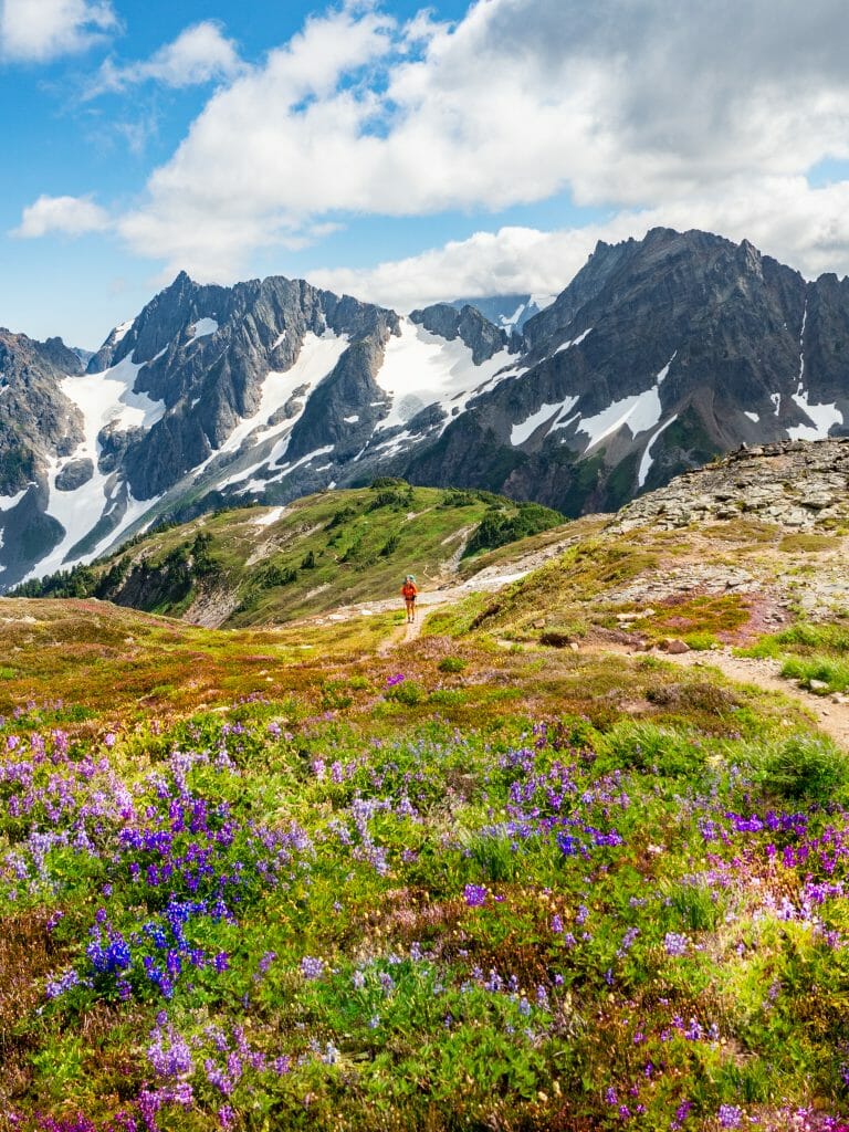
Pioneered in 1938 by the Ptarmigan Climbing Club, a group of 4 climbers out of Seattle who climbed 12 peaks and put up half as many first assents over just 13 days, the iconic Ptarmigan Traverse represents Washington mountaineering at its very finest. Each day brings high passes, steep glaciers, windy summits, and sparkling lakes, all set against the impossibly picturesque backdrop of the snow-capped North Cascades.
Although you could theoretically power through the 35mi traverse from Cascade Pass to Suiattle River Road in just 3 days, it would be doing the region a major disservice— allow at least a week to incorporate some of the many scenic detours and lofty climbing objectives along the way.
It’s worth noting that conditions along the Ptarmigan have changed dramatically over the years, and by the time I completed this trip in early August of 2021, the glaciers were almost unrecognisable from a previous trip dad had made in early August of 2012— we struggled to even get onto the glaciers, the transition from rock to snow a terrible mess, and then spent hours clawing our way up blue ice only to descend for several more hours over exposed talus that had completely melted out. Supposedly easy days were incredibly difficult, so perhaps the best advice is to tackle the traverse early season and come prepared for poor conditions that might delay progress.
Highlights from our 9-day trip were ascending the hulking LeConte Glacier, scrambling to the summit of Dome Peak, camping at the impossibly scenic White Rock Lakes, and watching the sunset from the Dana-Dome Glacier. Whatever your exact itinerary, though, this promises to be a challenging and completely exhilarating route with all the intrigue of a full-blown expedition.
Read more: WHAT FRESH HELL IS THIS?: PTARMIGAN TRAVERSE 2021
Protectorate: North Cascades National Park (trailhead to Cache Col) & then Glacier Peak Wilderness (Cache Col onwards)
Permits & fees: None (not required to display a pass at Cascade Pass TH, even though it’s technically in the NP)
Trailhead: Cascade Pass TH
Trail time: 3-12+ days (average 5 days, add time for more climbing objectives and side-trips)
Distance: 35mi+ / 56km+
Elevation gain: 14,000ft+ / 4,270m+ (depending on climbing objectives)
Technical difficulty: Hard, but depends on exact route (roped glacier travel, class 3-4 scrambling, very challenging route-finding)


2 | Mt. Rainier (via Emmons Glacier)
Proudly bearing the title of Washington’s highest mountain at 14,411ft, as well as being the most glaciated Peak in the continental US, Mt Rainier has earned a practically automatic spot on every West Coast mountaineer’s bucketlist. There’s hardly a more impressive or imposing volcano in the country, and certainly none so instantly recognisable as Rainier, rising dramatically behind the Seattle skyline in every depiction of the city and visible from far corners of the state in clear weather.
Although far from the most technical mountain, climbing Mt Rainier still requires a great deal of mental and physical effort— it’s more than 10,000ft from the trailhead to the summit, complicated by high altitude, ever-changing glacier features, and the mountain’s characteristically unpredictable weather conditions, which can take snow to ice and back to slush in a matter of hours.
There are heaps of routes up the mountain, but we particularly enjoyed the Emmons Glacier, which is typically among the easier summit options (if conditions cooperate) and yet sees relatively few climbers compared to the more popular DC route.
The approach begins from White River to Glacier Basin (3.5mi; 1280ft gain) before ascending 2000ft up the Inter Glacier to the loose ash and rock of Camp Curtis (8,685ft) and then continuing 700ft (vertical) to Camp Schurman (9,400ft), the true base camp for climbing up the Emmons Glacier. Most climbing parties depart around midnight and climb through the night to gain the summit in the early hours of the morning— the whole ordeal can be as quick as 8hrs and as long as 24hrs to and from Schurman, depending on conditions and the experience level of the group. It’s a major climb and one of the most memorable experiences I’ve ever had on a mountain!
Read more: CLIMBING MT RAINIER VIA CAMP SCHURMAN & THE EMMONS GLACIER
Protectorate: Mt Rainier National Park
Permits & fees: National Parks Pass ($30 for 7-day or $80 for annual); permit for site at Camp Schurman (hard to get!); climbing permit (issued at the ranger station, no reservation needed); and pay Climber Recovery Fee ($55; required prior to collecting your climbing permit)
Trailhead: White River TH (or via Sunrise for a longer approach)
Trail time: 2-4 days (from Camp Schurman, the climb took 14hrs + another 4hrs back to White River TH, but highly variable based on conditions)
Distance: 10mi+ / 16.1km+
Elevation gain: 10,300ft / 3,140m
Technical difficulty: Hard, but depends on conditions (roped glacier travel, constant use of ice axe and crampons, high altitude)


3 | The Enchantments
The aptly named Enchantments is one of the most unbelievably spectacular and highly coveted areas within the Alpine Lakes Wilderness of Eastern Washington, providing major draws for hikers, backpackers, trail runners, and climbers alike. Not only does it feature dozens of pristine mountain lakes and more aesthetic appeal than is possible to capture in any photo— it also hosts some of the most scenic, well-appointed campsites and unparalleled access to a number of impressive peaks, including Prusik, McClellan, and Dragontail.
It’s virtually impossible to score a backpacking permit these days, but you can also complete the entire 20+ mile trail in a single day without any permit, which opens up many possibilities for last-minute adventures. This is how we did the trail and, over the course of 12hrs, fell completely in love with the Enchantments— if you do score a camping permit, though, you’ll have so much more time to lounge at the lakes, bag peaks, and just generally soak in the views!
I’d recommend parking your vehicle at the Snow Lakes TH and then hitchhiking up the road to the Stuart Lake TH to begin the hike (it took us about 3min to get picked up and then we ended the hike already back at our van!). This will also bring you up Aasgard Pass and then down to Snow Lakes, tackling the steepest part of the hike as an ascent and the more gradual part as a descent, as well as squeezing the best views into the first 2/3rds (where day hikers will get to enjoy the lakes in the morning/afternoon).
From Stuart Lake, the hike is fairly gradual to Colchuck Lake, a gorgeous but overcrowded spot popular among day hikers, and then climbs much more dramatically (but truly not as bad as people would have you believe) to the trail’s high point, where the crowds immediately thin to a handful of backpackers and a few eager fast-packers. Once up Aasgard Pass, the core Enchantments unfurls before you, dozens of crystalline lakes shining beneath rugged peaks, waterfalls gushing in every direction, and adorable families of mountain goats frolicking around amongst it all. It’s hours of non-stop scenery all the way to Snow Lake, where the landscape eventually becomes somewhat unremarkable as you trudge the final miles to Snow Lakes TH. For all of the hype, The Enchantments really do deliver something special.
Protectorate: Alpine Lakes Wilderness
Permits & fees: Advance camping permit required for overnight trips (very hard to get!), but none required for a 1-day (self-issued at TH); NW Forest Pass to display on your car at the TH ($5 for day-pass or $30 annual)
Trailhead: Stuart Lake TH (recommended) or Snow Lakes TH
Trail time: 1-4 days (we completed the entire trail in 12hrs, but there’s heaps more to explore with additional time)
Distance: 20mi+ / 32km+
Elevation gain: 4,820ft / 1,470m
Technical difficulty: Easy (trail hike with no technical experience required)


4 | Sawtooth Summit Trail
Although the trail itself may not be well-known enough to be considered iconic, its main feature certainly is— there’s hardly a better place in the entire state to see golden larches.
For the uninitiated, larch season occurs every autumn, when the otherwise unremarkable alpine larch trees in the Pacific Northwest turn a vibrant gold before dropping all of their needles for the winter.
It’s the small geographical window, as well as the very narrow timeframe (and unpredictable weather this time of year), that makes golden larch season somewhat elusive and therefore incredibly captivating—if you know where to look and manage to time the season *just right*, it’s truly incredible to witness the deep green forests of the Cascades transition into an ethereal sea of gold.
Coupled with heather & huckleberry bushes that burn red in autumn and oak & maple leaves also in the midst of their fall change, there is no better time to tackle the Sawtooth Summit Trail, an exciting traverse from Prince Creek on Lake Chelan up into the Sawtooth Range and back down to Stehekin. En route there are several worthwhile summits, including the undemanding but spectacular Star and Courtney Peaks— this may just be one of the most underrated trails in Washington!
Read more: CHELAN SUMMIT TRAIL (DAYS 1 & 2): PRINCE CREEK TO STAR LAKE VIA STAR & COURTNEY PEAK
CHELAN SUMMIT TRAIL (DAYS 3 & 4): STAR LAKE TO STEHEKIN VIA BOULDER BUTTE & PURPLE PASS
Protectorate: Lake Chelan-Sawtooth Wilderness (first 2/3rds) & then Lake Chelan National Recreation Area (dropping into Lake Juanita)
Permits & fees: None (although camping permits are technically required once in the NRA)
Trailhead: Prince Creek TH (accessible via the Lady of the Lake)
Trail time: 3-4 days
Distance: 41mi / 66km
Elevation gain: 13,450ft / 4,100m
Technical difficulty: Easy-Moderate, depending on climbing objectives (Star is Class 3 and Courtney is Class 2, mostly trail hiking otherwise)


5 | Sahale Arm to Boston Basin via Mt Buckner & Sahale Peak
Among the most popular photo vantage points in the entire North Cascades, Sahale Glacier Camp is simply breathtaking. After hiking an incredibly gentle trail to Cascade Pass and then continuing through the heather to ascend a much steeper, rockier route to Sahale Arm, the entirety of the range seems to stretch before you, Doubtful Lake acting as a sparkling sapphire centrepiece to the dark granite and bright snowy slopes. You’d be hard-pressed to find a more impressive or commanding view without leaving a maintained trail, and only a matter of hours from the trailhead, to boot!
Unsurprisingly, Sahale Glacier Camp is a highly sought-after backpacking destination with a challenging permit lottery to match, but it’s also perfectly positioned to act as base camp for climbing Mt Buckner, Sahale Peak, and Shark Fin Tower, all worthwhile objectives in the immediate vicinity.
From Sahale Arm, we day-tripped the SW face of Buckner in a brutal 14hr day that was wildly complicated by changing conditions and an incredibly steep descent on soft snow, but the view from the summit was worth every ounce of effort. Sahale Peak is a much shorter and easier climb, with a quick snowfield ascent and Class 4 scramble, but both are highly recommended.
Descending from Sahale Peak via the Quien Sabe Glacier and dropping steadily into Boston Basin, an equally coveted area in the Cascades for hikers and climbers, will eventually connect you to a rough bushwhacking “path” through the trees that pops out just beneath the Cascade Pass TH on Cascade River Road. It’s a brilliant loop showcasing many of the region’s best features and most staggering views— but even if all you manage is a day hike into Sahale Arm or up Sahale Peak, it’s sure to be a highlight.
Read more: SAHALE ARM TO BOSTON BASIN VIA MT BUCKNER & SAHALE PEAK
Protectorate: North Cascades National Park
Permits & fees: Advance camping permit required for Sahale Arm and Boston Basin (very hard to get!)
Trailhead: Cascade Pass TH
Trail time: 3-4 days
Distance: 23mi / 37km (including peaks)
Elevation gain: 11,600ft / 3,535m
Technical difficulty: Hard (trail to Sahale Arm, but Class 4 up Sahale Peak and Class 3 up Buckner with challenging snow/glacier travel)


6 | Maple Pass Loop + Black Peak
Hardly any list of “best day hikes in the North Cascades” will overlook Maple Pass Loop, a very manageable, well-maintained trail wrapping around countless lakes and beneath innumerable peaks in the Wenatchee National Forest. The route particularly comes to life during the autumn months, when all the leaves have turned varying shades of red and orange and yellow, providing a striking contrast to the characteristic blue-green of the North Cascades.
You’ll never want for company on Maple Pass— I’d estimate there were 300 hikers on the September weekend we set out, but thankfully it’s possible to completely escape the crowds and extend your outing into a 2-3 night mountaineering adventure by detouring to climb nearby Black Peak.
Just beyond Heather Pass, you can deviate from the main trail (which has already started to drop from the high point at Maple Pass) and ascend a short distance to Lewis and Wing Lakes. As beautiful as Maple Pass may be, it’s truly no match for the scenery at Wing Lake, which, under ideal autumn conditions, is fully ringed by ethereal golden larches that seem to glow against the brilliant blue of the water and the soft blanket of early season snow.
It’s a scene nothing short of jaw-dropping, as well as the perfect camp for a leisurely ascent of Black Peak, one of the most enjoyable climbs around 9000ft and a route that doesn’t really require much snow experience. The following day, it’s a quick return to Heather Pass and an easy descent back to the trailhead, all the while feeling like you experienced a side of Maple Pass that few day hikers can even imagine.
Read more: MAPLE PASS LOOP & BLACK PEAK (DAY 1): RAINY PASS TO LEWIS LAKE VIA HEATHER PASS
MAPLE PASS LOOP & BLACK PEAK (DAYS 2 & 3): LEWIS LAKE TO WING LAKE & BLACK PEAK SUMMIT
Protectorate: Okanogan-Wenatchee National Forest
Permits & fees: None
Trailhead: Maple Pass TH
Trail time: 2-3 days (Maple Pass Loop can be completed in 1 day)
Distance: 13mi / 21km
Elevation gain: 6,500ft / 1,980m
Technical difficulty: Moderate (trail hike along Maple Pass, but Black Peak involves a short section of Class 4 right below the summit)


7 | Pacific Crest Trail
Stretching an incomprehensible 2,650 miles from Mexico to Canada through California, Oregon, and Washington, there’s no doubt that the Pacific Crest Trail is the West Coast’s most iconic thru-hike. Every April, several thousand hikers depart the Mexican border with alarmingly small packs chocked full of ultra light-weight gear, and by September, a few hundred of those hikers reach the Canadian border— but for about 6 weeks in between, PCTers are treated to all the splendour of the Washington Cascades.
It should go without saying that the PCT is a truly massive undertaking, and that’s whether you’re speed-hiking 45mi a day or taking the entire 6 months to complete. Even among avid hikers and experienced backpackers, it’s a real accomplishment— but not one that interests everyone.
For those of us who can’t quite justify spending half a year on just one outing, there are still some phenomenal stretches of the PCT that make for excellent backpacking trips. Among the best of these section hikes are Snoqualmie Pass to Stevens Pass (75mi); White Pass to Chinook Pass via Goat Rocks (28mi); and Stevens Pass to Rainy Pass (117mi).
I particularly recommend the hike from Stevens Pass to Chain Lakes, which passes through some of the most beautiful scenery in the Alpine Lakes Wilderness and traverses just beneath the Bull’s Tooth, a very entertaining crag climb to overlook the region’s many nearby peaks. We tackled the 32mi route in 3 days and felt like we’d experienced a beautiful slice of the PCT— and with time left over to hike and climb through dozens of other locations in the coming months.
Read more: BULLSEYE TRAVERSE (DAY 1): STEVENS PASS TO CHAIN LAKES VIA JOSEPHINE LAKE
BULLSEYE TRAVERSE (DAY 2): CHAIN LAKES TO FROSTY PASS VIA BULL’S TOOTH SUMMIT
Protectorate: Too many to name!
Permits & fees: See the PCTA for current permit info
Trailhead: PCT Southern Terminus
Trail time: up to 6 months
Distance: 2,650mi / 4,265km
Elevation gain: 315,000ft / 96,012m
Technical difficulty: Easy (although not an easy undertaking by any stretch of the imagination, no technical mountaineering experience required)
