
Last Updated on 22 April 2026
Described by many as the lovechild of Australia and New Zealand, Tasmania boasts some of our country’s most striking landscapes, greatest natural diversity, and finest bushwalking, all crammed onto a wonderfully wild and easily navigable island between Melbourne and Antarctica.
Whether it’s coastal scenery or vibrant beaches that strike your fancy, sub-alpine landscapes or jagged mountain peaks, unique geological phenomena or rare endemic species, remote excursions or quick afternoon escapes, it is literally ALL waiting for you in Tassie! Here’s everything you need to know about 8 of my favourite bushwalks— hopefully this post will inspire you to visit Tasmania’s truly magical outdoor paradise and discover why everyone is just so bananas about our little island state.


1 | Overland Track
- Trail time: 6 days
- Distance: 65-80km, depending on side-trips
- Getting there: Cradle Mountain-Lake St Clair National Park is a 2.5hr drive from Launceston airport or a 1.5hr drive from the Spirit of Tasmania ferry in Devonport
- Read my detailed planning guide for the Overland Track!
Meandering nearly 70km from Cradle Mountain to Lake St Clair along well-maintained natural trails and stretches of elevated boardwalk, Australia’s most iconic long-distance hike is nothing short of breathtaking.
Spend a week exploring lush forests, summiting jagged alpine peaks (including the iconic Cradle Mountain and Mt Ossa, Tassie’s highest!), watching the sunset over mountain tarns, and admiring the vast expanse of Tasmanian wilderness from rocky outcrops. You’re likely to meet wallabies, Tasmanian Devils, echidnas, and snakes on the trail, the full gambit of Aussie wildlife.
The best thing about this trek is its accessibility to hikers of all fitness levels: the walk is flat and fairly undemanding, save for a few steeper side-trips, and is truly a social experience. Stay in warm huts or on tent platforms, but either way, enjoy meeting people from all over Australia and learning something new on each day’s walk!


2 | Mt Amos Summit
- Trail time: 2hrs
- Distance: 4km return
- Getting there: Drive 2.5hrs from Hobart to reach Wineglass Bay walk carpark in Freycinet National Park
- Read my quick trail guide on summiting Mt Amos!
The immensely popular Wineglass Bay Lookout walk may be shorter and less strenuous, but the sweaty climb up Mt Amos offers indisputably better views of the brilliant aquamarine bay framed by powder-fine white sand.
Start from Freycinet National Park’s main carpark and head uphill, avoiding the milky sections of pink granite that have been polished to a practically frictionless surface by thousands of footsteps. This hike is a short but challenging ascent, but once at the top, it’s impossible not to gasp at the view over Wineglass Bay.
>>> Check out my day-hike packing list for all your Mt Amos trail essentials

3 | Cape Queen Elizabeth Track
- Trail time: 2hrs at high tide, 1.25hrs at low tide
- Distance: 6-7km return
- Getting there: Drive 30min from Hobart to Kettering and catch the Sealink across to Bruny Island, then drive to the Cape Queen Elizabeth trailhead on Bruny Island Main Road
- Read my quick trail guide on hiking to Cape Queen Elizabeth!
A short and undemanding walk from the Main Road of Bruny Island out to a sprawling (but surprisingly secluded) golden beach, the Cape Queen Elizabeth walk is one of the most stunning trails on this little island off an island off an island.
As beautiful as the beach vistas may be, though, it is the intriguing Mars Bluff Arch that really steals the show, wind-whipped and chiseled over thousands of years into fascinating geometric patterns. In low tide, it’s possible to walk a shorter and more direct route to the Arch, but even in high tide, this natural rock formation is impossibly photogenic, offering a window over the always-pumping Tasman Sea.
This is truly one of the most unique spots in Tasmania, and possibly even the world, so it is absolutely not to be missed when on Bruny Island!


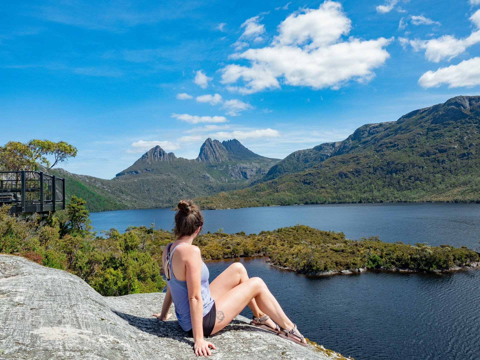
4 | Cradle Mountain Summit
- Trail time: 8hrs
- Distance: 13km
- Getting there: shuttle from Cradle Mountain Visitor Centre to Ronny Creek
It may not be the state’s highest mountain, but it is far and away the most iconic— its instantly recognisable swathe of jagged peaks gracing the cover of thousands of books, brochures, and blogs about Tasmania.
The summit of Cradle Mountain is every bit as stunning as the mountain itself, offering sprawling views over the textured landscape below, nearby Barn Bluff, and several dozen lakes and tarns. You can tack an ascent of this legendary mountain onto your Overland Track itinerary in about 2hrs, but it’s also possible as a long day hike from Dove Lake, taking in some of the surrounding scenery before starting the climb.
The first section is on a switch-backing trail, which gradually gives way to large dolerite boulders, and eventually becomes all-out scrambling for the remainder of the journey to the summit. Given the haphazard track and fairly steep ascent, this is a reasonably difficult hike only to be undertaken by those with appropriate gear and experience.
>>> Check out my day-hike packing list for all your Cradle Mountain essentials


5 | Three Capes Track
- Trail time: 4 days
- Distance: 48km
- Getting there: Drive about 1.5hrs from Hobart to Port Arthur, where a shuttle boat departs from the jetty
- Read my detailed planning guide for the Three Capes Track!
After more than 10 years of conceptualisation, design and rigorous construction, the incredible and highly anticipated Three Capes Track was opened to the public in late 2015. Now regarded as one of the best bushwalks in the entire country, experience otherworldly dolerite pillars and rugged coastal scenery that are entirely unique to the Capes, fall in love with the romantic desolation of the landscape, and immerse yourself in nature— all before retiring to a public hut that could be straight out of Architecture Australia.
This is the most expensive independent hike you can undertake in Tasmania, but the surreal beauty and immersive nature of this walk make it well-worth the price tag. Forty beautifully crafted seats along the trail correspond to stories in a booklet you’re handed upon check-in, providing depth and context to every step of your journey.
Forget about Point A to Point B— the Three Capes Track is all about the experience, so slow down and look at your surroundings, connect with the rich culture and history of the area, and be present in nature from start to finish!
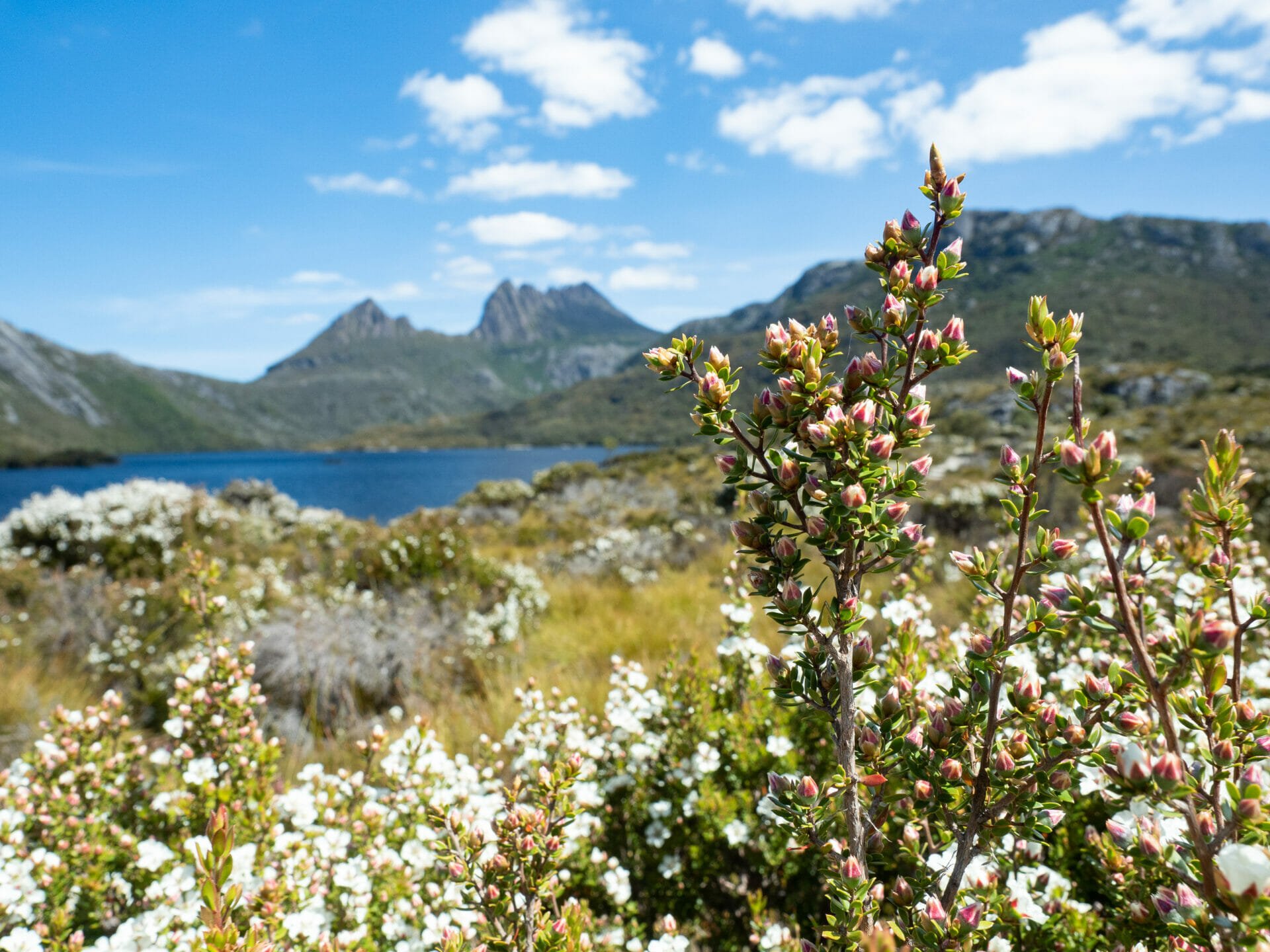
6 | Dove Lake Circuit
- Trail time: 2hrs
- Distance: 6km loop
- Getting there: Cradle Mountain-Lake St Clair National Park is a 2.5hr drive from Launceston airport or a 1.5hr drive from the Spirit of Tasmania ferry in Devonport
Although Cradle Mountain-Lake St Clair National Park may be best known for the Overland Track, there are a number of shorter hikes stretching across the park that are equally scenic (and more accessible if you’re not ready to commit to 6 days).
From the Visitors Centre, take the shuttle bus (included in the price of a Parks Pass) to Dove Lake and begin this short and gentle loop around picturesque Dove Lake. Both Glacier Rock and the Boatshed offer some of the best views of Cradle Mountain you’ll find in the entire park.
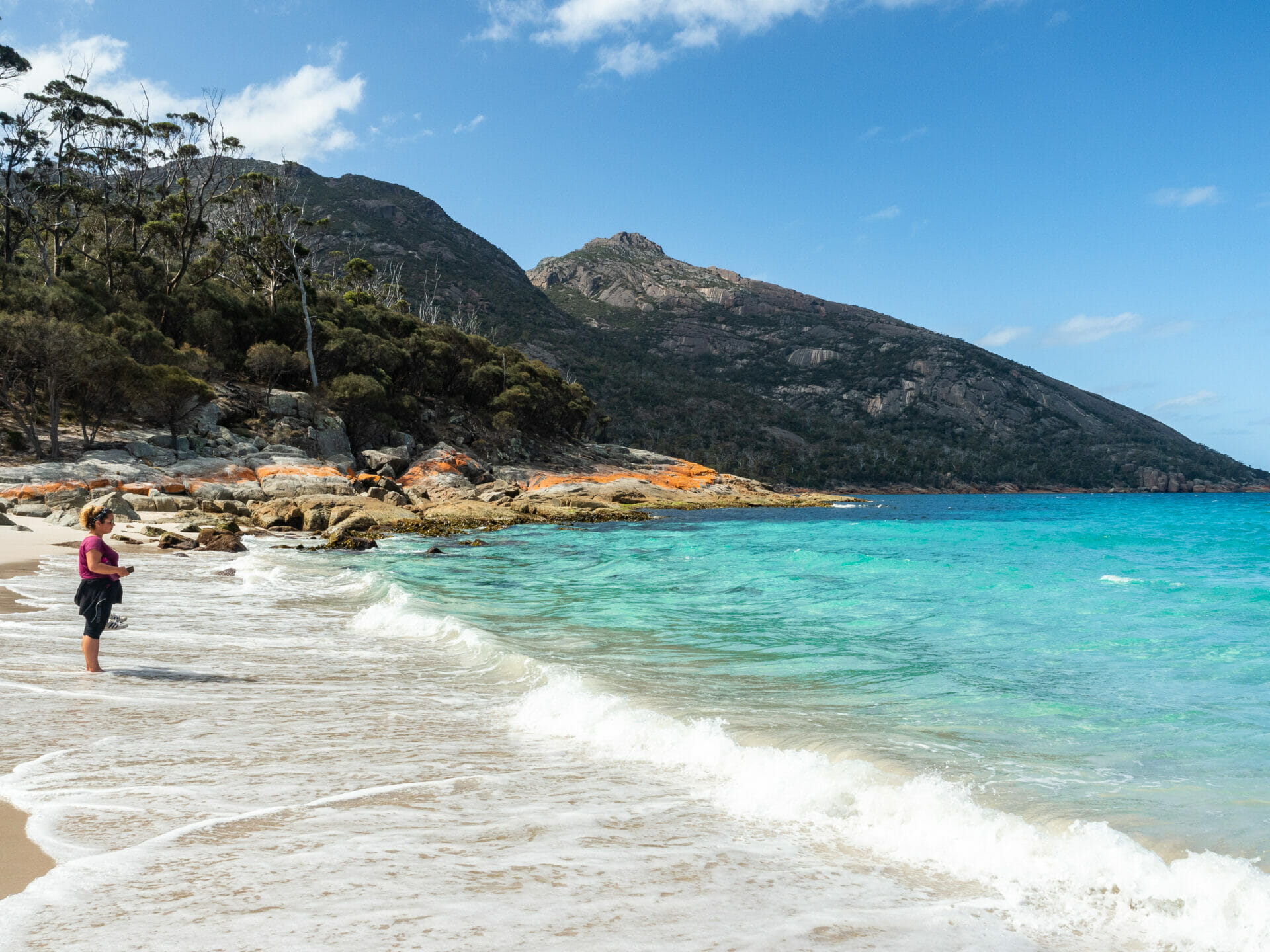
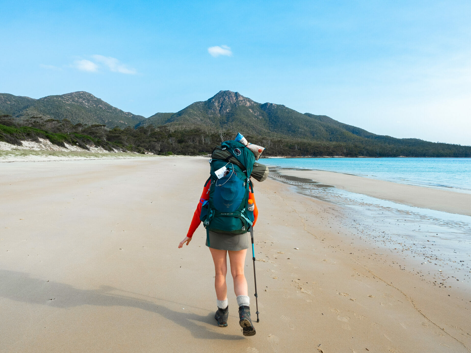
7 | Freycinet Hazards Circuit
- Trail time: 4.5hrs (best enjoyed as an overnighter)
- Distance: 17km loop
- Getting there: Freycinet National Park is a 2.5hr drive from Hobart or a 3.5hr drive from Launceston
- Read my quick trail guide on hiking the Freycinet Hazards Circuit!
Thousands of visitors make the short walk up to Wineglass Bay Lookout to see Tasmania’s most beautiful beach from above, but surprisingly few continue onwards to actually set foot on its perfectly white sand or swim in the crystal-clear water.
The ascent to Wineglass Bay Lookout can be a little steep, but the incline is short-lived and the reward of swimming in sheltered Wineglass Bay afterwards is enough to encourage even the most reluctant of hikers to push through. With camping at either Wineglass Beach or Hazards Beach, this is one of the best overnight walks in Freycinet National Park, and one that features plenty of flat beach walking and scenic ocean views.
For the ultimate experience, combine this 2-day adventure with a quick ascent of Mt Amos, departing from the same trailhead.


8 | Bay of Fires Lodge Walk
- Trail time: 4 days
- Distance: 33km, plus kayaking along Ansons River
- Getting there: As part of this all-inclusive walk, you are transported from Launceston to the Bay of Fires region in a private shuttle
Experience the characteristic white-sand beaches, turquoise waters, and vivid orange lichen of Tasmania’s Bay of Fires in unparalleled luxury with the Tasmanian Walking Company. This is the only hike on the list that I haven’t actually completed myself (the $3000AUD price tag is admittedly daunting), but while staying in Ansons Bay, we were invited to attend an open house at the Bay of Fires Lodge where we learned all about this incredible walk and got to experience some of the comforts first-hand.
Not only is the scenery along the trail breathtaking, but the entire hiking experience has been totally reinvented to incorporate every possible luxury — gourmet meals and pedicures await you post-hike, spa baths are perfectly positioned over the vibrant coastline, and the minimalist lodge has been designed specifically to give the impression of being “inside when outside, and outside when inside”, as one of the staff eloquently put it.
This is a hike for people who want to experience all the beauty and seclusion of the Australian bush without all the dirt or a heavy pack. I sincerely hope I make it back one day as a proper guest (if only for the spa bath)!

Hiking safety in Tasmania
- Tasmanian weather is wildly unpredictable, so pack and prepare for all conditions in a single day. This means carrying a jumper and rain jacket even on short hikes in the summer!
- Garmin inReach Mini 2, Lightweight and Compact Satellite Communicator, Hiking Handheld, OrangeIf you are hiking out of mobile reception (especially if you are hiking alone!), carry an SOS device like the Garmin inReach Mini so you’re able to call for help in the event of an emergency (weather, snake, or otherwise).
- Make sure to brush up on your snakebite care before hitting the trail and exercise particular caution when walking through bushes/shrubs. You can get an idea of how to use the Pressure Immobilisation Technique by watching this video on YouTube. Pack the necessary bandages in your First Aid Kit.
- On that note, always bring a First Aid Kit, even on short hikes! I sprained my ankle on the summit of Cradle Mountain and thankfully my parents had a supply of strapping tape and painkillers in their “trouble kit”, without which I might not have gotten off the mountain.
- Although they might make you look like a retiree, I still swear by my trekking poles for any steep or long hikes.
- Check out my complete day-hike packing list and multi-day hike packing lists for more gear recommendations!
Other tips for hiking in Tasmania
- Transport options around Tasmania are extremely limited, so it’s easiest to drive to all of these hikes yourself (see my guide to the Overland Track, this is a tricky one even with a car). That being said, it’s not impossible to hit the trail by using a combination of buses and private shuttles.
- The best options for hikers without a car: Bay of Fires Lodge Walk, Three Capes Track, Cradle Mountain summit, and Dove Lake Circuit.
- For any overnight hikes, you’ll need to buy fuel for your stove in Tasmania if you’re flying in (you can carry it on the ferry if you are driving). There are a number of outdoors shops in Launceston and Hobart, including Anaconda, where you can stock up on fuel, dehydrated mountain food, and most other camping/hiking essentials.
- Check out the freshly updated OUTDOOR GEAR section of my blog for detailed posts on camping gear, hiking layers, the best trail boots, backpacks, and more!
Read more about what to do in Tasmania
What to do in Tasmania: 30 amazing adventures on Australia’s island state
Cradle Mountain Canyoning: Jumping, sliding, & abseiling through Dove Canyon
Top 5 most beautiful spots to explore in Tasmania’s Bay of Fires
The Comments
Graeme PENNICOTT
Dear Brooke, Photo is looking up to Mt Pelion East NOT Mt Ossa. Also not a good look with picture sitting on Glacier Rock ( new viewing platform installed to reduce accidents on rock and also to protect it – it is part of the Tasmanian Wilderness World Heritage Area after all!) The photo of tent to the nw of Cradle is also not endearing as camping prohibited in day walks area! Otherwise a great article. Regards Graeme Pennicott, eco tourism wilderness guide
brooke brisbine
Graeme PENNICOTTHi Graeme,
Thank you for the correction, I’ll be sure to update the photo caption.
As for the tent photo, I sprained my ankle on the summit of Cradle Mountain and ended up camping at the base out of medical necessity. Within my Overland Track guide, I specify that camping is at designated huts/sites only 🙂
-Brooke