
What to do on Bruny Island: the perfect day-trip itinerary
Last Updated on 20 May 2025
Tasmania’s wild and beautiful Bruny Island may just be the most captivating island… off an island… off an island that you’ve ever visited. And although there are more than enough scenic spots and exciting activities to occupy an entire week on this Singapore-sized island, Bruny is readily accessible as a quick day-trip from Hobart, making it the perfect addition to any Tasmania itinerary.
Spend an entire day indulging in local treats like fresh oysters and gourmet cheese, exploring the island’s many beaches and scenic viewpoints on foot, searching for rare white wallabies or watching fairy penguins come in from the surf, and climbing to the top of Australia’s second-oldest lighthouse. Here is all the information you need to make the most of your day on magical Bruny Island.

Getting to Bruny Island
Unless you are cruising over on your sailboat (in which case, please pick me up), a ferry from mainland Tasmania is the only way to reach Bruny Island for your day of adventure.
Sealink operates a small vehicle ferry from Kettering, just 30min south of Hobart, that runs approximately every hour from 6.30 to 7pm (plus a few extra sailings during the summer months). As of yet, there’s no way to reserve spots in advance, so just rock up to the jetty 20min before departure and purchase your tickets from the little booth.
Fares are amazingly inexpensive— depending on the time of day, either $32 or $38 will buy return tickets for your car and everyone in it! Walk-ons are actually free, although I wouldn’t recommend this unless you have someone picking you up on the island, as there’s no obvious way to get around without a car. The crossing takes just 20min and then you can finally start your day on Bruny Island from Roberts Point in the northeast.

1 | Cape Queen Elizabeth Arch
After cruising off the ferry and onto the island, head less than 20min south down Bruny Island Main Road (B66) to reach your first stop, the Cape Queen Elizabeth trailhead. It’s pretty easy to miss if you don’t know where to look, so navigate to the vibrantly-signed Bruny Island Honey instead and then, immediately across the road, you’ll see a small carpark with a wide sandy trail leading off into the distance.
There are so many amazing places to see on Bruny that I’d recommend cutting down the full Cape Queen Elizabeth walk and only going as far as Mars Bluff to see the incredible rock Arch rising above the ocean, which is the highlight of the hike anyway. Set aside 2hrs for the entire excursion, although this can be shorter if you’re lucky enough to be here during low tide (there’s a very direct beach path if conditions allow— read more about that here).
Things to know:
- 2hrs return hike to the rocky Cape Queen Elizabeth Arch
- If walking at low tide and taking the beach path, the whole trail is flat and undemanding
- If walking at high tide and taking the Mars Bluff path, most of the trail is flat except for about 10min of climbing and 5min of descending to get to the beach
- You can still get the same amazing photos of the Cape Queen Elizabeth Arch in high tide, so don’t let that put you off!
- Check the current tides here
Read more: CAPE QUEEN ELIZABETH: DISCOVERING THE INCREDIBLE MARS BLUFF ARCH
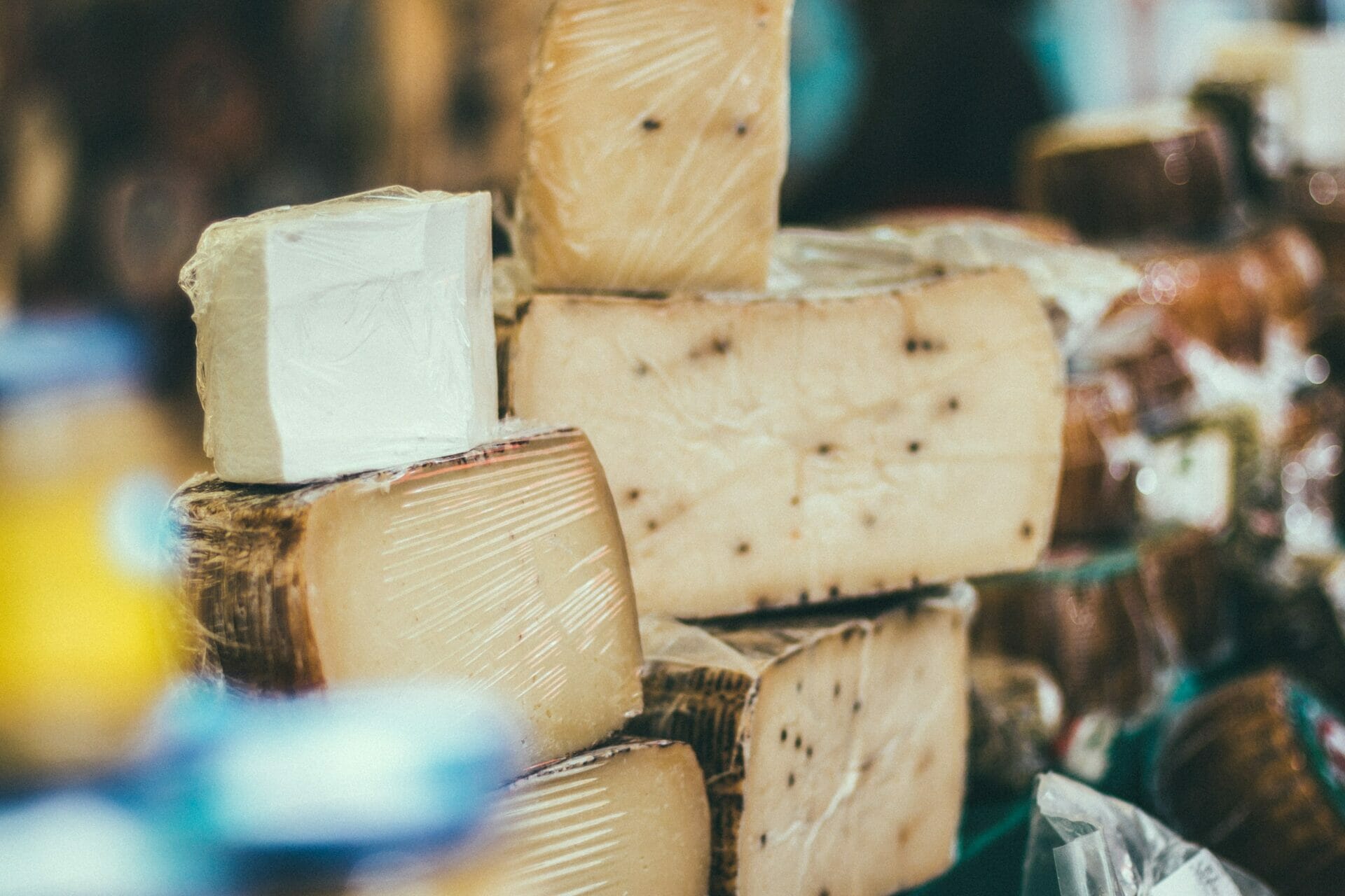
2 | Bruny Island Cheese & Beer Co.
Backtrack about 2min from the Cape Queen Elizabeth trailhead and Bruny Island Honey along the same main road to reach Bruny Island Cheese & Beer Co., very invitingly signed as “CHEESE AND BEER”.
This is an out-of-this-world local cheese shop, cafe, bakery, and brewery serving up cheese tasting boards, beer paddles (tastings of 4 different beers), fresh sourdough, local wine, and some pretty spectacular cheese-based lunch items such as woodfire pizza and croque monsieur.
They have a beautiful outdoor garden with heaps of seating, so take the opportunity to relax after your hike over a cheesy lunch and a cheeky afternoon beverage. Alternatively, about 100m down the road is Get Shucked, an immensely popular oyster bar offering a variety of cooked and fresh local oysters.
Things to know:
- $12 beer paddles let you taste 4 delicious beers
- For $5, order a cheese flight and sample delicious local varieties of both hard and soft cheese
- Enjoy a delicious lunch made with fresh-baked sourdough bread and Bruny Island Cheese
- This place can get busy, especially in summer or during the weekends, so allow plenty of time in your schedule for what will be a leisurely lunch
- If you fancy something a bit more fishy, head about 1min down the road to Get Shucked

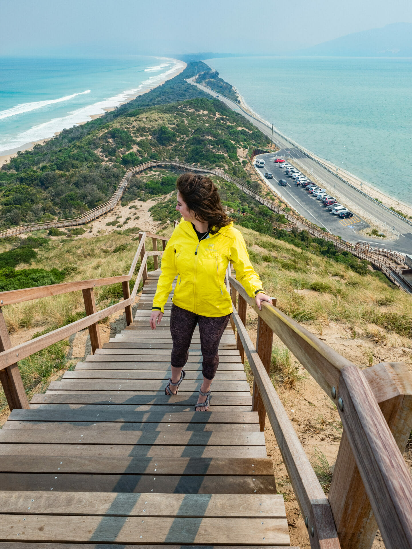
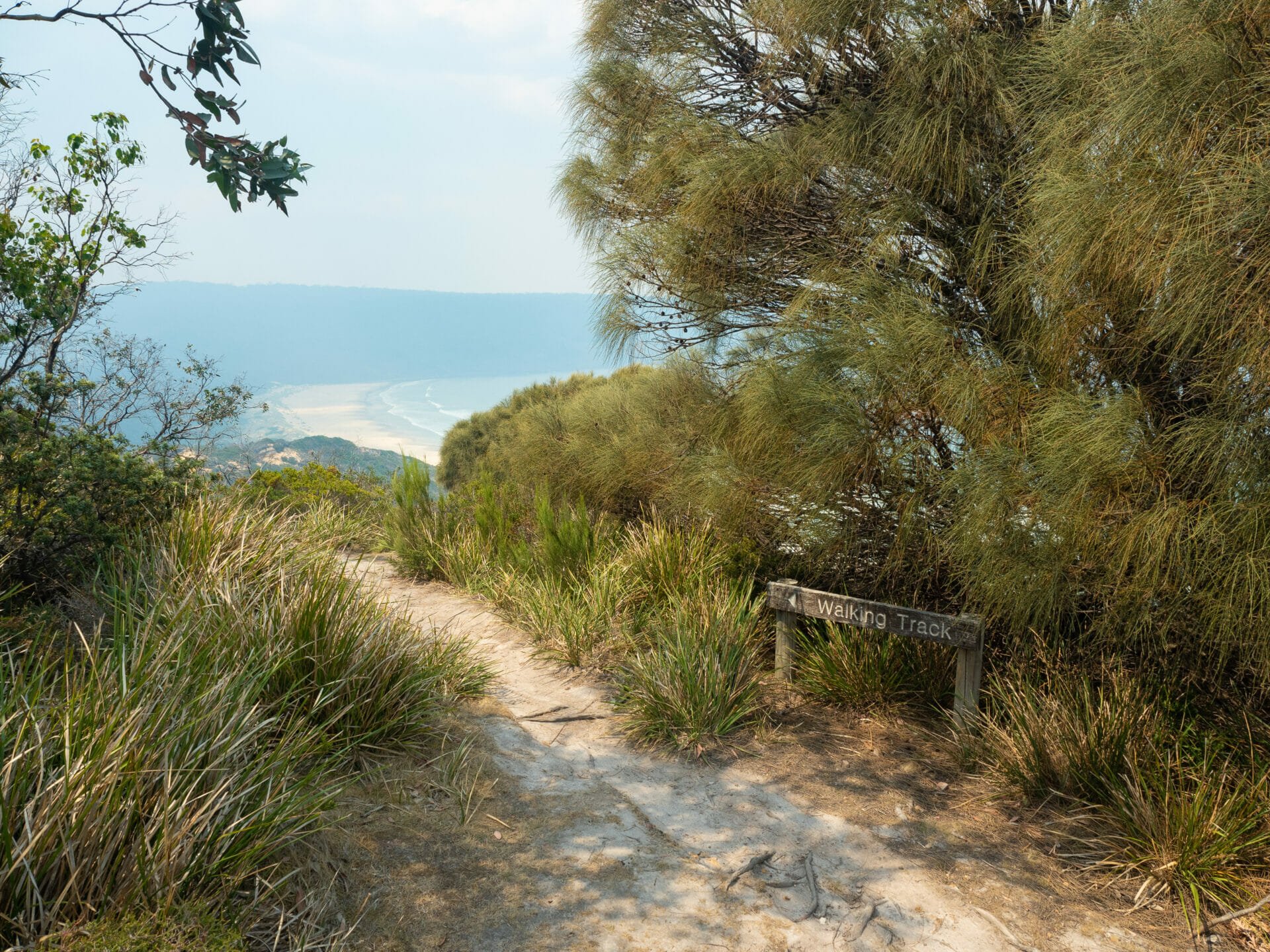
3 | Truganini Lookout at The Neck
The amazing view that put Bruny Island on my radar in the first place was The Neck, an impossibly narrow strip of sand connecting north and south Bruny together as a single island.
Driving just 8min down the road from Bruny Island Cheese & Beer Co., you’ll see a large carpark on the right side of the road beneath a long flight of wooden stairs. Even though it’s difficult to tell where the stairs finish as you climb higher and higher, you’ll reach Truganini Lookout in well under 5min and turn around to discover incredible sweeping views of the narrow beaches on either side of The Neck.
On a clear day, you can see far more of North Bruny’s landscape in the distance, but even in smoke (or rain or fog), it’s unsurprising that this is the island’s most iconic view!
Things to know:
- Allow 15min return to walk up to Truganini Lookout, enjoy the view, and return back to your car
- Even when conditions aren’t perfectly clear, this lookout is still breathtaking!
- Follow the boardwalks to explore the Neck Game Reserve, looking out for the many Fairy Penguins that have made burrows here— the best time to spot them is in the evening
- There’s also a little campground here about 20m off the beach

4 | Cape Bruny Lighthouse
After enjoying beautiful views of The Neck, hop back in the car for a 45min drive all the way to the tip of Bruny Island, cruising through South Bruny National Park to reach Cape Bruny. From the carpark, walk about 5min up the hill to see the lighthouse and enjoy all the incredible surrounding scenery. For a bird’s eye view, though, join a guided tour to climb the spiral staircase all the way to the top while learning about the fascinating history of Cape Bruny.
This heritage-listed lighthouse has a nearly 200 year legacy of guiding ships safely around the southern coast of Tasmania— first lit in 1838, continuously manned until 1993, and still proudly standing as the second oldest lighthouse in all of Australia.
Amazingly, the pearly 114m structure was completed in just 18 months by a team of 12 convicts who were promised their freedom in exchange for swift work. Considering the wind that blows on this southern coast of Tasmania is absolutely wicked, it’s quite a testament to the efforts of these 12 men that the ageing lighthouse is in such wonderful repair.
Things to know:
- Since Cape Bruny Lighthouse is in South Bruny National Park, you’ll need a Tasmanian National Parks Pass to enter— if you’re travelling around more of Tassie, you can buy an 8 week holiday pass valid at every NP
- Take a 30min guided tour of this heritage-listed lighthouse for $15 and learn all about its 200 year history
- The only way to access the lighthouse and climb to the top for photos is with the guided tour
- It’s a 75min drive from Cape Bruny back to the ferry at Roberts Point even you don’t stop at Adventure Bay, so definitely consider the time before you join a lighthouse tour

5 | Adventure Bay
Driving 50min from Cape Bruny, make your final stop of the day at Adventure Bay to look for the rare and elusive white wallabies that are unique to Bruny Island. Both Bennetts wallabies (the cute little brown ones that are all over Tasmania) and albino white wallabies can be spotted in the grass and bushes around the Bruny Island Cruises office, the Adventure Bay Caravan Park, and along other quiet roads at the south end of Adventure Bay.
As you might tell from my lack of white wallaby pictures, we didn’t manage to see one during our visit, but better time management throughout the day will mean that you have plenty of time to search until you spot one! After what I hope will be numerous sightings on your part, head back to the car to finish the 35min drive back to the Sealink ferry.
Things to know:
- Adventure Bay is the best place to spot white wallabies, which are endemic to Bruny Island
- The best time to spot white wallabies is in the evening, although people definitely get lucky at all times of the day if they are persistent
- Be sure to allow 35-40min to drive back to the ferry and still be early for the schedule sailing
- Try the incredible cherries while you’re waiting in the ferry queue, they make the perfect end-of-day snack
*Other important information for visiting Bruny Island
- If time (and money) allows, I would highly recommend taking a Bruny Island Cruise (operated by Pennicott Wilderness Journeys)— we did a cruise with the same company on the Tasman Peninsula and it was incredibly beautiful and so informative
- There’s not heaps of fuel to be found on the island, so try to stock up before leaving mainland Tassie— if not, there is a General Store at Adventure Bay that has petrol
- With more time, explore some of the island’s other great hikes: Fluted Cape, Mt. Mangana, Grass Point, etc
- Since you can’t reserve a spot on the ferry, be sure to arrive extra early for your return journey to avoid getting stuck on Bruny Island overnight. We queued up an hour early for the 7pm ferry and didn’t even make it on because the line was so long— we were extremely lucky that Sealink ran an extra ferry that night, but I certainly wouldn’t rely on it happening every time!


Read more about our adventures in Tasmania
THE OVERLAND TRACK: A COMPREHENSIVE DIY GUIDE TO TASMANIA’S MOST ICONIC MULTI-DAY HIKE
SUMMITING MT AMOS FOR THE ABSOLUTE BEST VIEW OF WINEGLASS BAY
WINEGLASS BAY: HIKING THE HAZARDS CIRCUIT IN FREYCINET NATIONAL PARK
TOP 5 MOST BEAUTIFUL SPOTS TO EXPLORE IN TASMANIA’S BAY OF FIRES
CAPE QUEEN ELIZABETH: DISCOVERING THE INCREDIBLE MARS BLUFF ARCH
The Comments
cowpoke
What’s up, Ι reɑd your blogs on a regular basis.
Your humoristic style is witty, keep up the good ѡork!
brooke brisbine
cowpokeThanks for following along 🙂
xx bb