• start here
  • about
  • group trips
  • brooke beyond

  • hiking guides
  • outdoor gear
    • hiking boots
    • hiking backpacks
    • cold-weather layers
    • backpacking tent
    • outdoor sleep system
    • backcountry food
    • day-hike packing list
    • hut-to-hut packing list
    • via ferrata packing list
    • backpacking packing list
    • mountaineering packing list

brooke beyond

Via Ferrata Gran Cir
Europe / Italy

Alta Via 2 (day 3): Rifugio Puez to Rifugio Pisciadú + Via Ferrata Gran Cir, Piz da Cir, Brigata Tridentina

25 September 2022

Last Updated on 22 April 2025

Day 3 is where via ferrata along AV2 really take centre stage, with three excellent climbs possible throughout the day. Even if you aren’t tackling my “adventure route” on your own hike, you’ll still have some unavoidable via ferrata cables today and may just find that it’s more fun than you’d thought!

To the eager climber, I’d also give the following advice: today’s via ferrata get bigger and better as you go, so assess how you’re tracking when you arrive to Jimmi Hütte and cut the first via ferrata if you have any concerns about fitting all 3 into the day. Whatever you do, don’t miss Brigata Tridentina up to Pisciadú; this is one of the best via ferrata in all of the Dolomites!

This comprehensive guide to Day 3 of Alta Via 2 contains detailed section times, route recommendations, adventurous side trips, via ferrata, and heaps of insider tips— use it to plan your hike & then refer back on the trail so you always know what to expect!

All my AV2 knowledge in one place: Alta Via 2: complete hiking + via ferrata route guide

Alta Via 2: Day 3 overview

Stats quoted here are for my recommended “adventure route” that incorporates side trips, summits & via ferrata whenever possible (in brackets, see stats for the standard AV2 route with no additions). 

  • Trail hours: 8hrs (4.5hrs without via ferrata)
  • Distance: 13km (10.5km without via ferrata)
  • Elevation gain & loss: 1450m up & 1155 down (945m up & 645m down without via ferrata)
  • Side trips: Via Ferrata Gran Cir (up & back; 1A), Via Ferrata Piz da Cir (small loop; 2A), Brigata Tridentina (en route; 3B)— refer to Tabacco Map 07 & Cicerone Vol.1 (routes 27, 26 & 28, respectively)
  • Huts: Rifugio Pisciadú
Alta Via 2 Italian Dolomites hiking via ferrata guide
Morning trail views on AV2
Alta Via 2 Italian Dolomites hiking via ferrata guide

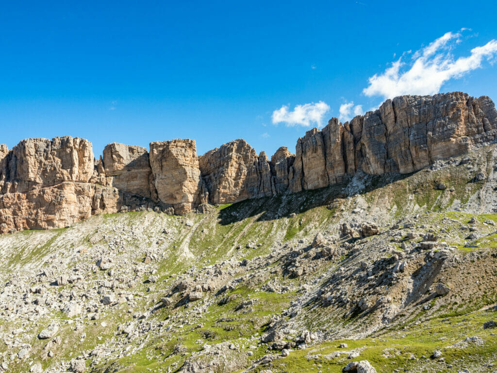
Rifugio Püez to Forcela di Cir via Sass da Ciampac (2.5hrs)

Leaving the hut early this morning for an adventure-filled day, the trail first meanders gently along a grassy plateau, peering occasionally to the deep valley floor some thousand metres below. 

The scenery is incredibly dramatic, especially as you descend a trail that seems almost to be suspended in the air. After 45min, you’ll reach a junction— continue straight for the classic AV2 route, but head left for a recommended alternative that climbs to the summit of Sass da Ciampac for incredible views.

If you’re following my custom AV2 adventure route, the best way to stay on track is with my custom-built AV2 GPS map— packed with detailed daily tracks, 168+ waypoints, all the side trips & via ferrata described in this guide, detours to avoid challenging sections, plus extensive trail notes to help you navigate AV2 like an expert.

Available in both JSON and GPX formats, the map works seamlessly with GPS apps like CalTopo, Gaia, and AllTrails, or with Garmin devices and watches. Head to my storefront to purchase the map!

Alta Via 2 Italian Dolomites hiking via ferrata guide
Sass da Ciampac
Alta Via 2 Italian Dolomites hiking via ferrata guide
Small alpine tarns visible from Sass da Ciampac

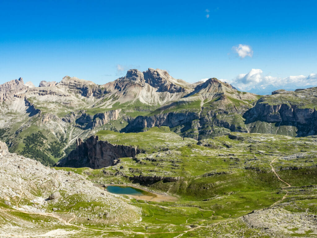
Allow about 1hr from the trail junction to reach the high point at Sass da Ciampac and drop quickly back to the main trail, rejoining just before a wooden gate that brings you into a large rock basin. 

After another descent and short climb, you’ll arrive to a second gate about 30min later, which marks Furcela de Cir. Surely you’ll know it by the surprising number of people, something unusual up until today on AV2— prepare for company as you hike onwards. 

Alta Via 2 Italian Dolomites hiking via ferrata guide
Approaching Furcela de Cir

Forcella di Cir to Jimmi Hütte (30min)

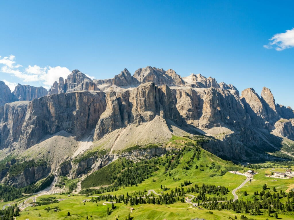
From the bustling Forcella di Cir, it’s a quick drop on a rocky trail to reach Jimmi Hütte, which serves a number of well-rated food and drink options on their breathtaking balcony looking right out onto the striking Sella Group. 

Alta Via 2 Italian Dolomites hiking via ferrata guide
Sella Group from the patio at Jimmi Hutte
Alta Via 2 Italian Dolomites hiking via ferrata guide
Via Ferrata Gran Cir

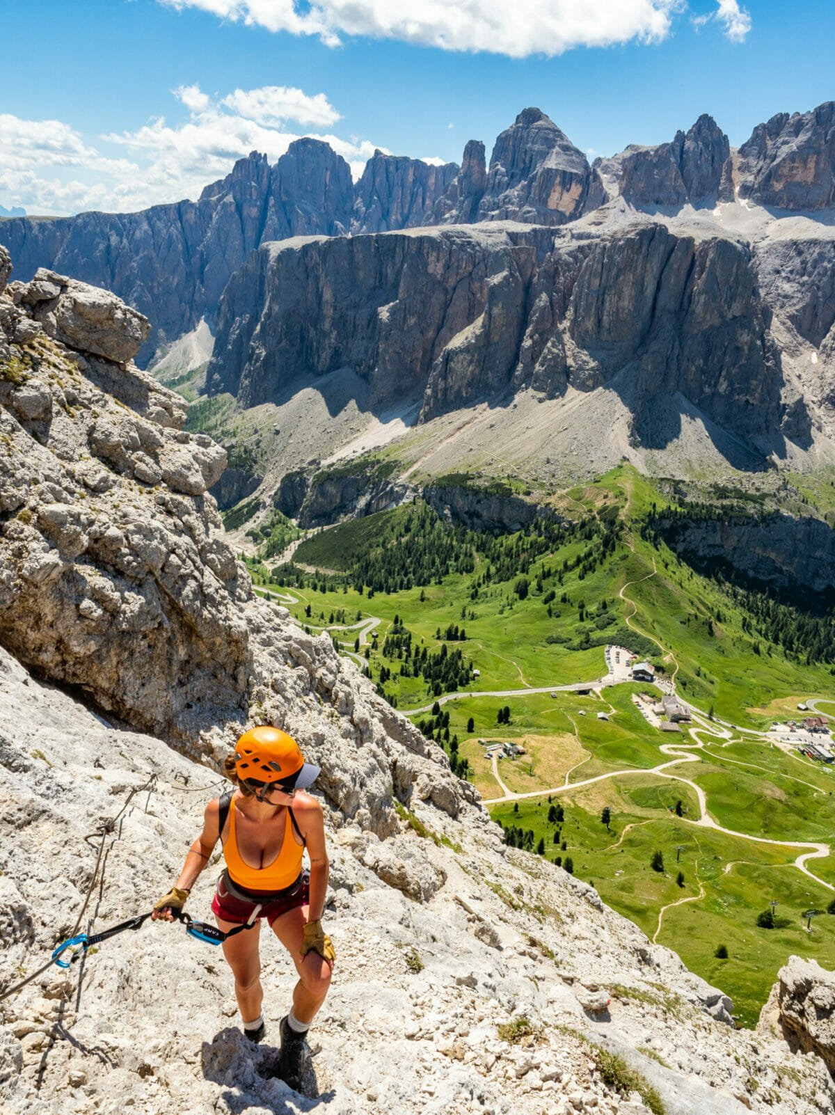
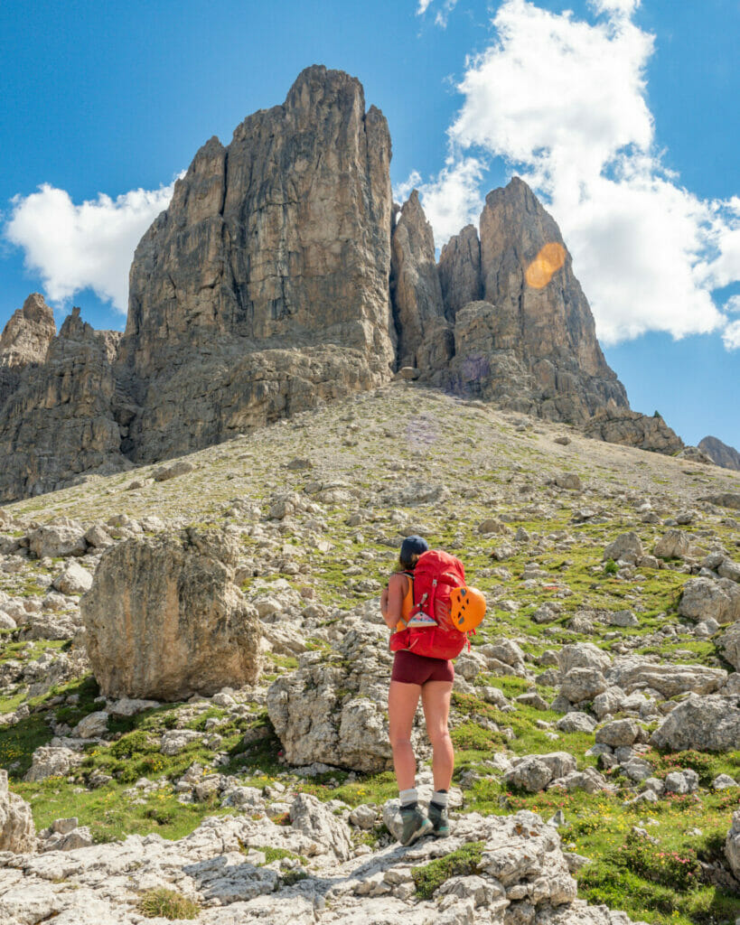
Via Ferrata Gran Cir (1A; 1hr)

Hustling along from the hut, travel about 10min on trail before turning right at a subtlety marked junction (look for a low sign that notes “AVS CIR”) and climb up a steep rocky trail towards the day’s first via ferrata. If you’re keen to move a little faster, look for a spot to drop your big pack off the side of the trail before continuing upwards. 

Allow 30min to the summit of Gran Cir, the highest peak in the Cir Group, and another 30min to return to your pack. The route is only 1A, so it’s a nice warm up for the 2A and 3B still to come!

Alta Via 2 Italian Dolomites hiking via ferrata guide
Via Ferrata Piz da Cir

Via Ferrata Piz da Cir (2A; 1hr)

Continue a short distance along the main trail before connecting to another uphill route that leads to Via Ferrata Piz da Cir. It’s an incredibly popular (and therefore crowded) route, but for good reason— if you felt that you only had time for one of these first two via ferrata, this would absolutely be the pick.

This 2A is a lot more scrambly than the 1A completed previously, and you’ll want to allow about 50min up and 20min down (but expect to be queuing occasionally on your ascent). 

Alta Via 2 Italian Dolomites hiking via ferrata guide

The down path actually goes up and over the summit to return via a different route with fewer cables and more scree. It’s short enough, and drops you directly onto the cable car to Passo Gardena (6€; pay on arrival to the lower station). 

If time allows, grab a beer at Dantercëpies and enjoy the view!

Alta Via 2 Italian Dolomites hiking via ferrata guide
Hiking towards Via Ferrata Brigata Tridentina

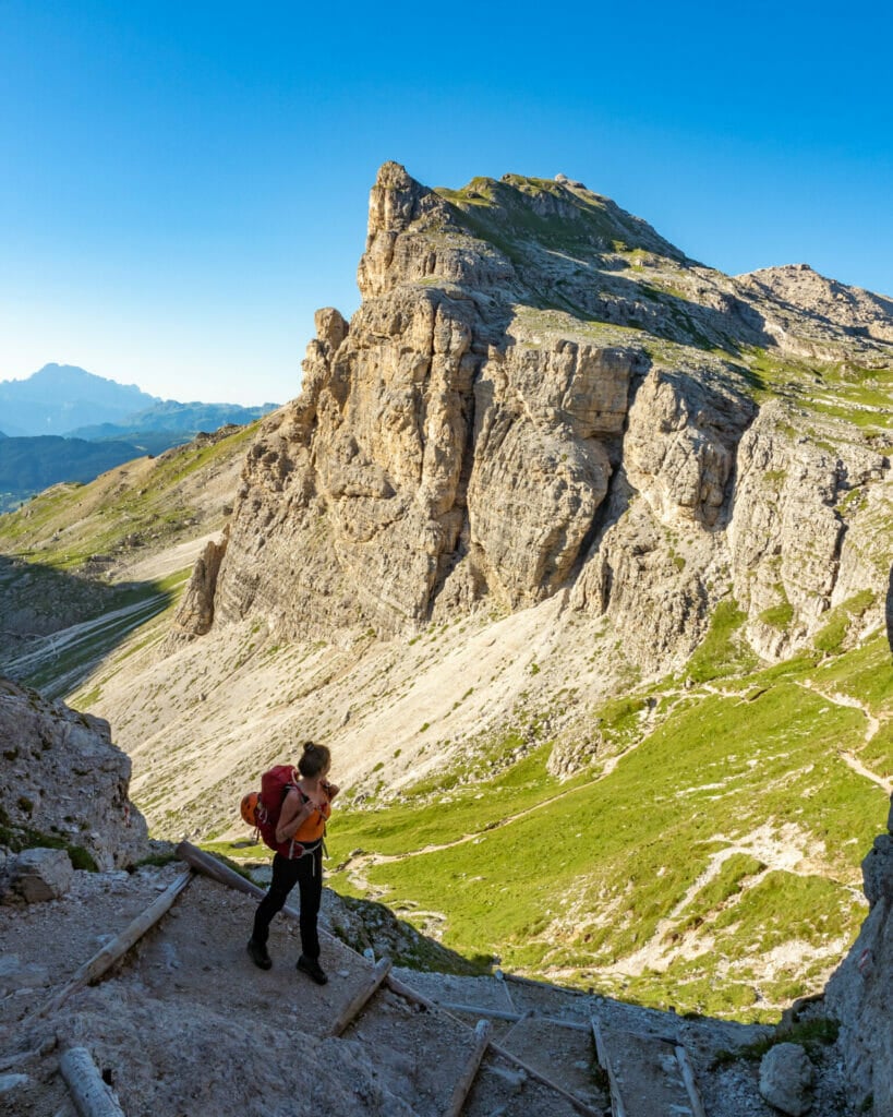
Via Ferrata Brigata Tridentina (3B; 3.5hrs)

From the cable car at Passo Gardena, it’s a somewhat steep 20min ascent to a trail junction in the scree field— by afternoon, dozens of hikers are descending from the via ferrata and the ascent path straight ahead/left (not up!) is practically empty. 

New to via ferrata? Read this post: Introduction to via ferrata + complete via ferrata gear list

Alta Via 2 Italian Dolomites hiking via ferrata guide

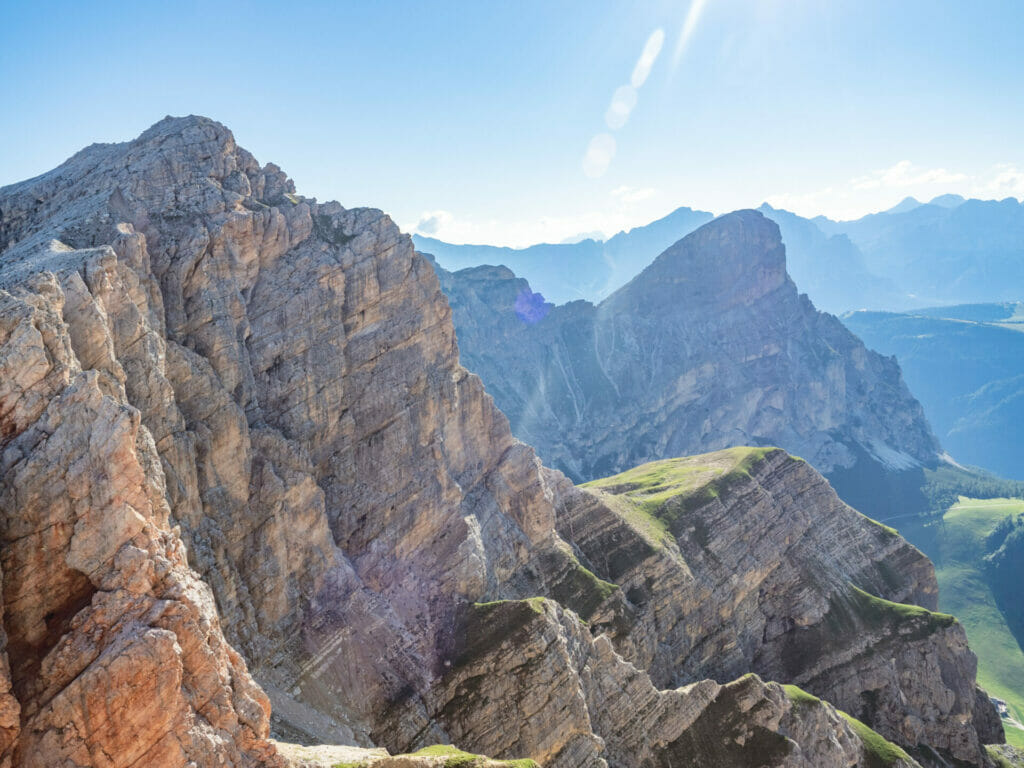
Follow signs towards Rifugio Pisciadú that specify “Via Ferrata/Kleitersteig” (there is an alternate route that requires much less climbing, but where’s the fun in that?!). The trail leads you below the high limestone walls and, after about 45min of hiking, onto cables that continue for more than 400m (1300ft) of sustained climbing. 

Before the final stretch (about 2hrs from the cable car), there is a bail-out marked as “easy climb” that avoids the most challenging via ferrata, but also many of the route highlights— stay the course and continue upwards for another 40min!

Alta Via 2 Italian Dolomites hiking via ferrata guide

Built in 1960 by the Italian Army, Brigata Tridentina is considered to be the most popular via ferrata in the Dolomites and we’d heard plenty of stories about long lines and tediously slow crowds, but were entirely alone on the cables by about 4pm— yet another reason this I’d recommend stopping to complete the 2 earlier via ferrata and arriving here later in the day!

Between the hundreds of pegs, stemples, rungs, ladders, and even the iconic suspension bridge connecting Torre Exner and Mur de Pisciadú, Brigata Tridentina was hands down one of the best via ferrata I completed during my month in the Dolomites. 

Alta Via 2 Italian Dolomites hiking via ferrata guide
Via Ferrata Brigata Tridentina
Alta Via 2 Italian Dolomites hiking via ferrata guide
Dad on the iconic Tridentina suspension bridge

Difficult sections add intrigue, the exposure is often dizzying, and the views are unparalleled— this is via ferrata at its absolute best, a true marriage between big wall climbing and protected scrambling. 

Once off the wire, it’s a gradual 15min ascent to Rifugio Pisciadú, where a well-earned meal and a deep sleep await! 

Alta Via 2 Italian Dolomites hiking via ferrata guide
Rifugio Pisciadú

Night 3: Rifugio Pisciadú 

Situated beneath the soaring Sella Group and Pisciadú Peak, Rifugio Pisciadú was among my favourite huts (and the approach on Via Ferrata Brigata Tridentina definitely influenced that!). 

The views are wonderful, the dining room is cozy and intimate, the food is simple but hearty, and the rooms are very comfortable— we managed to get a 6-bed dorm all to ourselves, which meant double pillows and double blankets for me. Reserve Rifugio Pisciadú on their website.

  • Rooms: 33/39€ (dorms/small rooms) OR 70/75€ (dorms/small rooms)
  • Food: A la carte (approx 10-15€ for dinner, 14€ for 1L of wine, 4.5€ Aperol spritz, 12€ breakfast) or half board
  • Showers: 3€ for 4min (4-6pm only)
  • Connectivity: Wifi & weak mobile signal
  • Alpine club discount: -14.5€ room only OR -10€ half board

For more information on what to expect in a mountain hut & how to prepare for your stay: Everything you need to know about mountain huts (rifugi) in the Italian Dolomites

Alta Via 2 Italian Dolomites hiking via ferrata guide

Read more about Alta Via 2

  • start here ->Detailed AV2 Route Guide
  • ALTA VIA 2 (DAY 1): BRESSANONE TO RIFUGIO GENOVA + VIA FERRATA SASS D’PUTIA
  • ALTA VIA 2 (DAY 2): RIFUGIO GENOVA TO RIFUGIO PUEZ + VIA FERRATA PIZ DULEDA
  • ALTA VIA 2 (DAY 3): RIFUGIO PUEZ TO RIFUGIO PISCIADÚ + VIA FERRATA GRAN CIR, PIZ DA CIR, BRIGATA TRIDENTINA
  • ALTA VIA 2 (DAY 4): RIFUGIO PISCIADÚ TO PIZ BOÈ + CIMA PISCIADÚ
  • ALTA VIA 2 (DAY 5): PIZ BOÈ TO RIFUGIO CASTIGLIONI MARMOLADA 
  • ALTA VIA 2 (DAY 7): LAGO DI FEDAIA TO SAN PELLEGRINO + VIA FERRATA DELLE TRINCEE
  • ALTA VIA 2 (DAY 8): PASSO SAN PELLEGRINO TO RIFUGIO VOLPI AL MULAZ
  • ALTA VIA 2 (DAY 9): RIFUGIO MULAZ TO RIFUGIO PRADIDALI
  • ALTA VIA 2 (DAY 10): RIFUGIO PRADIDALI TO RIFUGIO TREVISO + VIA FERRATA PORTON & NICO GUSELLA
  • ALTA VIA 2 (DAY 11): RIFUGIO TREVISO TO PASSO CEREDA + VIA FERRATA CANALONE
  • ALTA VIA 2 (DAY 12): PASSO CEREDA TO RIFUGIO BOZ
  • ALTA VIA 2 (DAY 13): RIFUGIO BOZ TO CROCE D’AUNE
  • navigate confidently on & off the trail ->AV2 adventure route GPS map!
TAGS:alta via 2dolomites
2 Comments
Share
brooke beyond

Hey, I'm Brooke and I'm obsessed with getting off the beaten path, exploring backcountry gems & travelling beyond the ordinary! I left Australia 5 years ago after finishing a PhD in Biomechanics & have been travelling the world full-time ever since (joined by my life/climbing partner, James). Whether it’s road-tripping through Mexico, climbing alpine peaks in the Andes, scuba diving in the Red Sea, or tackling epic via ferrata in the Dolomites, I hope this blog will inspire your future adventures & help you find wonder in every corner of the globe. xx bb

Leave a Comment Cancel Comment

The Comments

  • Nisha
    24 July 2023

    Hi Brooke – thanks so much for writing such a thorough blog on the via ferrata. My BF and I are doing sections of the AV2 and plan on doing Brigata Tridentina. Is there a specific brand you recommend for the gear? We would be buying everything (helmets, harness, etc.) so figured I’d ask. Thanks so much!

    Reply
    • brooke brisbine
      Nisha
      26 November 2023

      Hi Nisha, thanks so much for reading! You can see a short list of recommended gear in this post: https://brookebeyond.com/alta-via-2-in-the-italian-dolomites-complete-hiking-via-ferrata-guide

      My full Alta Via packing list will be published later this week 🙂

      xx bb

      Reply

You May Also Like

8 July 2017

En route to Geneva

29 November 2016

Poffertjes, Vespas & Anne Frank: A guide to visiting Amsterdam

25 July 2018

The ultimate Ireland travel guide

hi, I’m brooke!

I'm obsessed with getting off the beaten path, exploring backcountry gems & travelling beyond the ordinary! I left Australia 5 years ago after finishing a PhD in Biomechanics & have been travelling the world full-time ever since (now joined by my life/climbing partner, James). I hope this blog will inspire your future adventures & help you find wonder in every corner of the globe. xx bb

read my story
currently exploring

currently exploring

mexico

read our gear guides

🥾 hiking boots

🎒 hiking backpacks

🌨️ cold-weather layers

⛺️ backpacking & alpine tents

🛌 sleeping bag & pads

🍪 backcountry food

📸 travel camera gear

✈️ travel clothing

trail guides

summit guides

itineraries

outdoor gear

GPS maps

recent posts

  • Climbing Iztaccíhuatl volcano

    2-week Mexico volcanoes itinerary: climbing Pico de Orizaba, Izta, Malinche & Toluca

    3 June 2025
  • Mexico City: the perfect 5-day itinerary for CDMX

    31 May 2025
  • Climbing Iztaccíhuatl volcano

    Driving in Mexico: essential road trip guide for foreigners

    28 May 2025
  • 10-day Rwanda road trip itinerary: gorillas, volcanoes & Lake Kivu

    25 May 2025
  • 2-week Patagonia itinerary: best of Torres del Paine & Los Glaciares/El Chaltén

    22 May 2025

@brookebeyond_
brooke ✨travel & mountain gal

@brookebeyond_

  • magical moments in the swiss alps 🐄🇨🇭🧀🫐🌺
.
.
.
.
.
#swissalps #switzerland #matterhorn #zermatt #oeschinensee #lucerne #jungfraujoch #grindelwald #swisssummer
  • NEW CUSTOM GPS MAPS!!

✨ shop.brookebeyond.com ✨

Before every single backpacking trip, hut-to-hut & alpine expedition, I spend dozens of hours on @caltopo building a GPS track to help me navigate along the route confidently, especially when venturing off the standard trail (which I nearly always do) 🗺️

And after MANY requests to share my custom routes, I now have 8 super detailed JSON/GPX files that you can use to plan your own epic adventure off the beaten path— navigating right off your smartphone!!!

Available maps:
🇮🇹 Alta Via 2
🇮🇹 Alta Via 4
🇫🇷 Mont Blanc Summit
🇵🇪 Huayhuash Circuit
🇦🇷 Aconcagua Summit
🇺🇸 Teton Crest Trail
🇨🇱 O-Circuit
🇦🇷 Fitz Roy Loop
+ more coming soon!

These maps include detailed route beta with hundreds of waypoints, essential trail stats, alternatives & bailouts, side-trips & summits, all based on my adventurous modifications to these amazing routes! 

They’ve been heavily tested by friends & readers, and I’m confident you won’t find another resource like them 🗺️

✨ shop.brookebeyond.com ✨

ps. If you’ve bought one of my maps this summer (AV2 + AV4 have been SO popular!), I’d love to hear from you!!
  • We took our own engagement photos in the Swiss Alps this summer and here’s how it went 👉🏼

(#8 might just be my personal fave 😂)

ALSO this post is for anyone who’s gotten the (woefully mistaken) impression that I am “naturally photogenic”
  • absolutely one of the most amazing little hikes we did in Switzerlnad this summer (& the competition was stiff) 🤩🏔️🌞🌸

📍Saxer Lücke

GETTING THERE: catch the Frümsen gondola to Staubernkanzel

HIKE: 1hr (2.5km, 250m gain) to this amazing viewpoint

WHEN TO GO: the best lighting is in the afternoon, these photos were taken around 4pm and it just kept getting better!
.
.
.
.
.
#swissalps #switzerland #saxerlücke #swisssummer #alpstein
  • the BEST easy hike in Zermatt 🏔️🥾✨

For spectacular views of the Matterhorn, the enormous Monte Rosa massif, and the Gorner Glacier (as well as 29 peaks over 4,000m!), there’s no better EASY hike than Riffelberg to Gornergrat, accessible via the Gornergrat Railway in Zermatt. 

The hike only takes about 2hrs at a leisurely pace (I did it 7 weeks after knee surgery!), so it’s suitable for families and non-hikers with even a basic level of fitness 🏃🏻‍♀️

🇨🇭 START FROM ZERMATT
- purchase tickets (day-of is fine) from Gornergrat Railway, right across from Zermatt train station

🚞 GORNERGRAT RAILWAY
- tickets from Zermatt to Riffelberg cost 42CHF ($50USD)— there’s no discount for return, so keep it flexible by purchasing one-way
- the train takes the about 25min, sit on the right side for best views!
- when you finish the hike at Gornergrat, buy a one-way ticket back to Zermatt for 66CHF ($80USD)
- save 50% on tickets with the Swiss Half Fare Card— the pass costs 120CHF ($150USD) and lasts for a whole month, it’s almost always worth it!) 

🥾 HIKE DETAILS: RIFFELSEE TO GORNERGRAT
- the route is 5km with 560m elevation gain (entirely uphill)
- the best views of the Matterhorn are around Riffelsee, where several small lakes offer perfect reflections
- near Rotenboden (the train station in between Riffelberg & Gornergrat), there are excellent rocky viewpoints of both Matterhorn and Monta Rosa— it’s easy to find quiet views if you hike around a bit!
- as you get closer to Gornergrat, Monte Rosa and the Gorner Glacier are right in your face
- almost everyone does this hike in reverse (Gornergrat to Riffelberg), I just personally hate hiking downhill— but you can swap if you’d rather descend the entire way!
  • 2 months after knee surgery and barely a week after I stopped walking with a knee brace and cane, I was honestly so proud to be able to do this (objectively very easy) 5km hike with 250m gain— it may not seem like much, but for me, this was a HUGE step forward 🥹

📍 Saxer Lücke, Switzerland 

it’s been an extremely challenging recovery, both physically and mentally… but the milestone moments always fill me with hope that things are indeed getting better ❤️‍🩹

special shoutout to my fiancé/hiking partner/personal cheering squad @slatojc for slowing down with me on the trail and always offering a hand down slippery rocks before I even have to ask
  • it’s another “if it wasn’t so stupid beautiful, I’d never set foot in this country again because it’s bleeding me dry” kinda summer 🇨🇭🌸☀️🏔️🦋✨

(hands up if you feel personally victimised by Swiss prices but you can’t stay away because MOUNTAINS 😭😭)
  • magical summer sunsets in Switzerland ✨
.
.
.
.
#swissalps #stoosridge #swisssummer #sunset
  • BEST EASY HIKES IN SWITZERLAND 🇨🇭❤️‍🩹

just 2 months after knee surgery, I found myself travelling through Switzerland— in search of easy hikes that were actually accessible post-op 🩼 

luckily, there’s hardly a better place in the world for easy hiking than the Swiss Alps!!

so whether you’re recovering from an injury, hiking with older parents/young children, or just a non-hiker who loves an epic view, this short list of HIGH VALUE viewpoints & hikes offer the most spectacular mountain scenery with minimal challenge

💸 BUDGET TIP: buy the Swiss Half Fare Card to save 50% all these gondolas and trains, which can seriously add up!!

- Stoos Ridge: take the Stoosbahn to the little village of Stoos + walk about 15min to the chairlift that can take you all the way up to Fronalpstock— you can walk as little or as much as you want up here, the views are amazing right away
- Riffelsee: take the Gornergrat Railway from Zermatt to Riffelsee + hike 20min to the 2 beautiful alpine lakes (then either hike 1hr up to Gornergrat or catch the train)
- Saxer Lücke: catch a gondola + hike 1hr (2.5km, 250m gain) to this amazing viewpoint— hardest on this list and not suitable for those with extremely limited mobility 
- Kleine Scheidegg: take the train or the gondola from Grindelwald + hike about 20min uphill to the lake
- Jungfraujoch: from Kleine Scheidegg, take the gondola to Jungfraujoch + walk around the viewing platforms
- Trockener Steg: take the gondola from Zermatt + walk 10min from the top of the cable car to the lake for incredible Matterhorn views
- Oeschinensee: 20min walk from the top of the Kandersteg cable car to the lake (bus also available), then you can walk as little or as much as you want around the lake or on the famous Panorama Trail
.
.
.
.
.
#easyhikes #swissalps #matterhorn #jungfraujoch #oeschinensee #stoos #switzerland
follow @brookebeyond_

travel beyond the ordinary

Explore my travel guides, custom itineraries & blog posts with an interactive world map ✨

all destinations

  • magical moments in the swiss alps 🐄🇨🇭🧀🫐🌺
.
.
.
.
.
#swissalps #switzerland #matterhorn #zermatt #oeschinensee #lucerne #jungfraujoch #grindelwald #swisssummer
  • NEW CUSTOM GPS MAPS!!

✨ shop.brookebeyond.com ✨

Before every single backpacking trip, hut-to-hut & alpine expedition, I spend dozens of hours on @caltopo building a GPS track to help me navigate along the route confidently, especially when venturing off the standard trail (which I nearly always do) 🗺️

And after MANY requests to share my custom routes, I now have 8 super detailed JSON/GPX files that you can use to plan your own epic adventure off the beaten path— navigating right off your smartphone!!!

Available maps:
🇮🇹 Alta Via 2
🇮🇹 Alta Via 4
🇫🇷 Mont Blanc Summit
🇵🇪 Huayhuash Circuit
🇦🇷 Aconcagua Summit
🇺🇸 Teton Crest Trail
🇨🇱 O-Circuit
🇦🇷 Fitz Roy Loop
+ more coming soon!

These maps include detailed route beta with hundreds of waypoints, essential trail stats, alternatives & bailouts, side-trips & summits, all based on my adventurous modifications to these amazing routes! 

They’ve been heavily tested by friends & readers, and I’m confident you won’t find another resource like them 🗺️

✨ shop.brookebeyond.com ✨

ps. If you’ve bought one of my maps this summer (AV2 + AV4 have been SO popular!), I’d love to hear from you!!
  • We took our own engagement photos in the Swiss Alps this summer and here’s how it went 👉🏼

(#8 might just be my personal fave 😂)

ALSO this post is for anyone who’s gotten the (woefully mistaken) impression that I am “naturally photogenic”
  • absolutely one of the most amazing little hikes we did in Switzerlnad this summer (& the competition was stiff) 🤩🏔️🌞🌸

📍Saxer Lücke

GETTING THERE: catch the Frümsen gondola to Staubernkanzel

HIKE: 1hr (2.5km, 250m gain) to this amazing viewpoint

WHEN TO GO: the best lighting is in the afternoon, these photos were taken around 4pm and it just kept getting better!
.
.
.
.
.
#swissalps #switzerland #saxerlücke #swisssummer #alpstein
  • the BEST easy hike in Zermatt 🏔️🥾✨

For spectacular views of the Matterhorn, the enormous Monte Rosa massif, and the Gorner Glacier (as well as 29 peaks over 4,000m!), there’s no better EASY hike than Riffelberg to Gornergrat, accessible via the Gornergrat Railway in Zermatt. 

The hike only takes about 2hrs at a leisurely pace (I did it 7 weeks after knee surgery!), so it’s suitable for families and non-hikers with even a basic level of fitness 🏃🏻‍♀️

🇨🇭 START FROM ZERMATT
- purchase tickets (day-of is fine) from Gornergrat Railway, right across from Zermatt train station

🚞 GORNERGRAT RAILWAY
- tickets from Zermatt to Riffelberg cost 42CHF ($50USD)— there’s no discount for return, so keep it flexible by purchasing one-way
- the train takes the about 25min, sit on the right side for best views!
- when you finish the hike at Gornergrat, buy a one-way ticket back to Zermatt for 66CHF ($80USD)
- save 50% on tickets with the Swiss Half Fare Card— the pass costs 120CHF ($150USD) and lasts for a whole month, it’s almost always worth it!) 

🥾 HIKE DETAILS: RIFFELSEE TO GORNERGRAT
- the route is 5km with 560m elevation gain (entirely uphill)
- the best views of the Matterhorn are around Riffelsee, where several small lakes offer perfect reflections
- near Rotenboden (the train station in between Riffelberg & Gornergrat), there are excellent rocky viewpoints of both Matterhorn and Monta Rosa— it’s easy to find quiet views if you hike around a bit!
- as you get closer to Gornergrat, Monte Rosa and the Gorner Glacier are right in your face
- almost everyone does this hike in reverse (Gornergrat to Riffelberg), I just personally hate hiking downhill— but you can swap if you’d rather descend the entire way!
magical moments in the swiss alps 🐄🇨🇭🧀🫐🌺
.
.
.
.
.
#swissalps #switzerland #matterhorn #zermatt #oeschinensee #lucerne #jungfraujoch #grindelwald #swisssummer
magical moments in the swiss alps 🐄🇨🇭🧀🫐🌺
.
.
.
.
.
#swissalps #switzerland #matterhorn #zermatt #oeschinensee #lucerne #jungfraujoch #grindelwald #swisssummer
magical moments in the swiss alps 🐄🇨🇭🧀🫐🌺
.
.
.
.
.
#swissalps #switzerland #matterhorn #zermatt #oeschinensee #lucerne #jungfraujoch #grindelwald #swisssummer
magical moments in the swiss alps 🐄🇨🇭🧀🫐🌺
.
.
.
.
.
#swissalps #switzerland #matterhorn #zermatt #oeschinensee #lucerne #jungfraujoch #grindelwald #swisssummer
magical moments in the swiss alps 🐄🇨🇭🧀🫐🌺
.
.
.
.
.
#swissalps #switzerland #matterhorn #zermatt #oeschinensee #lucerne #jungfraujoch #grindelwald #swisssummer
magical moments in the swiss alps 🐄🇨🇭🧀🫐🌺
.
.
.
.
.
#swissalps #switzerland #matterhorn #zermatt #oeschinensee #lucerne #jungfraujoch #grindelwald #swisssummer
magical moments in the swiss alps 🐄🇨🇭🧀🫐🌺
.
.
.
.
.
#swissalps #switzerland #matterhorn #zermatt #oeschinensee #lucerne #jungfraujoch #grindelwald #swisssummer
magical moments in the swiss alps 🐄🇨🇭🧀🫐🌺
.
.
.
.
.
#swissalps #switzerland #matterhorn #zermatt #oeschinensee #lucerne #jungfraujoch #grindelwald #swisssummer
magical moments in the swiss alps 🐄🇨🇭🧀🫐🌺
.
.
.
.
.
#swissalps #switzerland #matterhorn #zermatt #oeschinensee #lucerne #jungfraujoch #grindelwald #swisssummer
magical moments in the swiss alps 🐄🇨🇭🧀🫐🌺
.
.
.
.
.
#swissalps #switzerland #matterhorn #zermatt #oeschinensee #lucerne #jungfraujoch #grindelwald #swisssummer
magical moments in the swiss alps 🐄🇨🇭🧀🫐🌺
.
.
.
.
.
#swissalps #switzerland #matterhorn #zermatt #oeschinensee #lucerne #jungfraujoch #grindelwald #swisssummer
magical moments in the swiss alps 🐄🇨🇭🧀🫐🌺
.
.
.
.
.
#swissalps #switzerland #matterhorn #zermatt #oeschinensee #lucerne #jungfraujoch #grindelwald #swisssummer
magical moments in the swiss alps 🐄🇨🇭🧀🫐🌺
.
.
.
.
.
#swissalps #switzerland #matterhorn #zermatt #oeschinensee #lucerne #jungfraujoch #grindelwald #swisssummer
@brookebeyond_
@brookebeyond_
•
Follow
magical moments in the swiss alps 🐄🇨🇭🧀🫐🌺 . . . . . #swissalps #switzerland #matterhorn #zermatt #oeschinensee #lucerne #jungfraujoch #grindelwald #swisssummer
1 day ago
View on Instagram |
1/5
NEW CUSTOM GPS MAPS!!

✨ shop.brookebeyond.com ✨

Before every single backpacking trip, hut-to-hut & alpine expedition, I spend dozens of hours on @caltopo building a GPS track to help me navigate along the route confidently, especially when venturing off the standard trail (which I nearly always do) 🗺️

And after MANY requests to share my custom routes, I now have 8 super detailed JSON/GPX files that you can use to plan your own epic adventure off the beaten path— navigating right off your smartphone!!!

Available maps:
🇮🇹 Alta Via 2
🇮🇹 Alta Via 4
🇫🇷 Mont Blanc Summit
🇵🇪 Huayhuash Circuit
🇦🇷 Aconcagua Summit
🇺🇸 Teton Crest Trail
🇨🇱 O-Circuit
🇦🇷 Fitz Roy Loop
+ more coming soon!

These maps include detailed route beta with hundreds of waypoints, essential trail stats, alternatives & bailouts, side-trips & summits, all based on my adventurous modifications to these amazing routes! 

They’ve been heavily tested by friends & readers, and I’m confident you won’t find another resource like them 🗺️

✨ shop.brookebeyond.com ✨

ps. If you’ve bought one of my maps this summer (AV2 + AV4 have been SO popular!), I’d love to hear from you!!
@brookebeyond_
@brookebeyond_
•
Follow
NEW CUSTOM GPS MAPS!! ✨ shop.brookebeyond.com ✨ Before every single backpacking trip, hut-to-hut & alpine expedition, I spend dozens of hours on @caltopo building a GPS track to help me navigate along the route confidently, especially when venturing off the standard trail (which I nearly always do) 🗺️ And after MANY requests to share my custom routes, I now have 8 super detailed JSON/GPX files that you can use to plan your own epic adventure off the beaten path— navigating right off your smartphone!!! Available maps: 🇮🇹 Alta Via 2 🇮🇹 Alta Via 4 🇫🇷 Mont Blanc Summit 🇵🇪 Huayhuash Circuit 🇦🇷 Aconcagua Summit 🇺🇸 Teton Crest Trail 🇨🇱 O-Circuit 🇦🇷 Fitz Roy Loop + more coming soon! These maps include detailed route beta with hundreds of waypoints, essential trail stats, alternatives & bailouts, side-trips & summits, all based on my adventurous modifications to these amazing routes! They’ve been heavily tested by friends & readers, and I’m confident you won’t find another resource like them 🗺️ ✨ shop.brookebeyond.com ✨ ps. If you’ve bought one of my maps this summer (AV2 + AV4 have been SO popular!), I’d love to hear from you!!
3 days ago
View on Instagram |
2/5
We took our own engagement photos in the Swiss Alps this summer and here’s how it went 👉🏼

(#8 might just be my personal fave 😂)

ALSO this post is for anyone who’s gotten the (woefully mistaken) impression that I am “naturally photogenic”
We took our own engagement photos in the Swiss Alps this summer and here’s how it went 👉🏼

(#8 might just be my personal fave 😂)

ALSO this post is for anyone who’s gotten the (woefully mistaken) impression that I am “naturally photogenic”
We took our own engagement photos in the Swiss Alps this summer and here’s how it went 👉🏼

(#8 might just be my personal fave 😂)

ALSO this post is for anyone who’s gotten the (woefully mistaken) impression that I am “naturally photogenic”
We took our own engagement photos in the Swiss Alps this summer and here’s how it went 👉🏼

(#8 might just be my personal fave 😂)

ALSO this post is for anyone who’s gotten the (woefully mistaken) impression that I am “naturally photogenic”
We took our own engagement photos in the Swiss Alps this summer and here’s how it went 👉🏼

(#8 might just be my personal fave 😂)

ALSO this post is for anyone who’s gotten the (woefully mistaken) impression that I am “naturally photogenic”
We took our own engagement photos in the Swiss Alps this summer and here’s how it went 👉🏼

(#8 might just be my personal fave 😂)

ALSO this post is for anyone who’s gotten the (woefully mistaken) impression that I am “naturally photogenic”
We took our own engagement photos in the Swiss Alps this summer and here’s how it went 👉🏼

(#8 might just be my personal fave 😂)

ALSO this post is for anyone who’s gotten the (woefully mistaken) impression that I am “naturally photogenic”
We took our own engagement photos in the Swiss Alps this summer and here’s how it went 👉🏼

(#8 might just be my personal fave 😂)

ALSO this post is for anyone who’s gotten the (woefully mistaken) impression that I am “naturally photogenic”
We took our own engagement photos in the Swiss Alps this summer and here’s how it went 👉🏼

(#8 might just be my personal fave 😂)

ALSO this post is for anyone who’s gotten the (woefully mistaken) impression that I am “naturally photogenic”
We took our own engagement photos in the Swiss Alps this summer and here’s how it went 👉🏼

(#8 might just be my personal fave 😂)

ALSO this post is for anyone who’s gotten the (woefully mistaken) impression that I am “naturally photogenic”
@brookebeyond_
@brookebeyond_
•
Follow
We took our own engagement photos in the Swiss Alps this summer and here’s how it went 👉🏼 (#8 might just be my personal fave 😂) ALSO this post is for anyone who’s gotten the (woefully mistaken) impression that I am “naturally photogenic”
6 days ago
View on Instagram |
3/5
@brookebeyond_
@brookebeyond_
•
Follow
absolutely one of the most amazing little hikes we did in Switzerlnad this summer (& the competition was stiff) 🤩🏔️🌞🌸 📍Saxer Lücke GETTING THERE: catch the Frümsen gondola to Staubernkanzel HIKE: 1hr (2.5km, 250m gain) to this amazing viewpoint WHEN TO GO: the best lighting is in the afternoon, these photos were taken around 4pm and it just kept getting better! . . . . . #swissalps #switzerland #saxerlücke #swisssummer #alpstein
1 week ago
View on Instagram |
4/5
the BEST easy hike in Zermatt 🏔️🥾✨

For spectacular views of the Matterhorn, the enormous Monte Rosa massif, and the Gorner Glacier (as well as 29 peaks over 4,000m!), there’s no better EASY hike than Riffelberg to Gornergrat, accessible via the Gornergrat Railway in Zermatt. 

The hike only takes about 2hrs at a leisurely pace (I did it 7 weeks after knee surgery!), so it’s suitable for families and non-hikers with even a basic level of fitness 🏃🏻‍♀️

🇨🇭 START FROM ZERMATT
- purchase tickets (day-of is fine) from Gornergrat Railway, right across from Zermatt train station

🚞 GORNERGRAT RAILWAY
- tickets from Zermatt to Riffelberg cost 42CHF ($50USD)— there’s no discount for return, so keep it flexible by purchasing one-way
- the train takes the about 25min, sit on the right side for best views!
- when you finish the hike at Gornergrat, buy a one-way ticket back to Zermatt for 66CHF ($80USD)
- save 50% on tickets with the Swiss Half Fare Card— the pass costs 120CHF ($150USD) and lasts for a whole month, it’s almost always worth it!) 

🥾 HIKE DETAILS: RIFFELSEE TO GORNERGRAT
- the route is 5km with 560m elevation gain (entirely uphill)
- the best views of the Matterhorn are around Riffelsee, where several small lakes offer perfect reflections
- near Rotenboden (the train station in between Riffelberg & Gornergrat), there are excellent rocky viewpoints of both Matterhorn and Monta Rosa— it’s easy to find quiet views if you hike around a bit!
- as you get closer to Gornergrat, Monte Rosa and the Gorner Glacier are right in your face
- almost everyone does this hike in reverse (Gornergrat to Riffelberg), I just personally hate hiking downhill— but you can swap if you’d rather descend the entire way!
@brookebeyond_
@brookebeyond_
•
Follow
the BEST easy hike in Zermatt 🏔️🥾✨ For spectacular views of the Matterhorn, the enormous Monte Rosa massif, and the Gorner Glacier (as well as 29 peaks over 4,000m!), there’s no better EASY hike than Riffelberg to Gornergrat, accessible via the Gornergrat Railway in Zermatt. The hike only takes about 2hrs at a leisurely pace (I did it 7 weeks after knee surgery!), so it’s suitable for families and non-hikers with even a basic level of fitness 🏃🏻‍♀️ 🇨🇭 START FROM ZERMATT - purchase tickets (day-of is fine) from Gornergrat Railway, right across from Zermatt train station 🚞 GORNERGRAT RAILWAY - tickets from Zermatt to Riffelberg cost 42CHF ($50USD)— there’s no discount for return, so keep it flexible by purchasing one-way - the train takes the about 25min, sit on the right side for best views! - when you finish the hike at Gornergrat, buy a one-way ticket back to Zermatt for 66CHF ($80USD) - save 50% on tickets with the Swiss Half Fare Card— the pass costs 120CHF ($150USD) and lasts for a whole month, it’s almost always worth it!) 🥾 HIKE DETAILS: RIFFELSEE TO GORNERGRAT - the route is 5km with 560m elevation gain (entirely uphill) - the best views of the Matterhorn are around Riffelsee, where several small lakes offer perfect reflections - near Rotenboden (the train station in between Riffelberg & Gornergrat), there are excellent rocky viewpoints of both Matterhorn and Monta Rosa— it’s easy to find quiet views if you hike around a bit! - as you get closer to Gornergrat, Monte Rosa and the Gorner Glacier are right in your face - almost everyone does this hike in reverse (Gornergrat to Riffelberg), I just personally hate hiking downhill— but you can swap if you’d rather descend the entire way!
2 weeks ago
View on Instagram |
5/5

  • start here
  • about
  • group trips
  • destinations
  • hiking guides
  • outdoor gear
  • custom GPS maps
  • privacy
  • contact

COPYRIGHT © 2025 BROOKE BEYOND. TRAVEL BEYOND THE ORDINARY. Site Powered by Pix & Hue.


Loading Comments...